Automated georeferencing of digitized map images

Inactive Publication Date: 2006-02-23
TELE ATLAS NORTH AMERICA
View PDF53 Cites 289 Cited by
  • Summary
  • Abstract
  • Description
  • Claims
  • Application Information

AI Technical Summary

Benefits of technology

[0018] The present invention provides an elegant, simple, and powerful manner of performing an automated georeferencing process. The present invention advantageously includes a platform-independent, server-side software package that allows users to accurately create and edit georeferenced images using a geographic database, a metadata source, and a repository of raster image data.
[0019] The present invention cartographically aligns raster images to geographic vector data sets so that the images may be co-positioned with the geographic vector data sets for use in geographic display and editing environments. The co-registration and display permits a meaningful overlay of the data sets. With this accurate overlay, a comparison of vector data to the correctly-registered images permits improvement and updating of the vector data based on the physical relationships between the vec

Problems solved by technology

In conventional systems, this cartographic alignment is often performed manually by analysts and mapping technicians, requiring considerable operator attention to process the images.
The alignment process requires significantly greater resources when the images are rotated or when common landmarks between the two data sources are difficult to discern.
However, the system and method of the '804 patent does not determine the accuracy of the geographic images using metadata prior to associating the first feature with the second feature.
Additionally, the '804 patent does not provide a means to deal with to image information; instead, landmarks (features) must first be created or extracted in some way before the technique may be used.
The '851 patent uses vector-based data only and provides no means for dealing with raster images.
Additionally, the '851 patent does not make use of centroid determination to accurately generate map representation vectors for use in conflating map representation vectors and target vectors in arriving at an accurate composite image.
However, the '279 patent provides only a one-way correction based upon the feature data composition.
Also, the '279 patent provide

Method used


Image

  • Automated georeferencing of digitized map images
  • Automated georeferencing of digitized map images
  • Automated georeferencing of digitized map images

Examples


Embodiment Construction

[0038] The invention is described in detail with particular reference to certain preferred embodiments, but with the spirit and scope of the invention, the invention is not limited to such embodiments. Those of skill in the art will appreciate that various features, variations, and modifications can be included or excluded, with the limits defined by the claims and the requirements of a particular use.

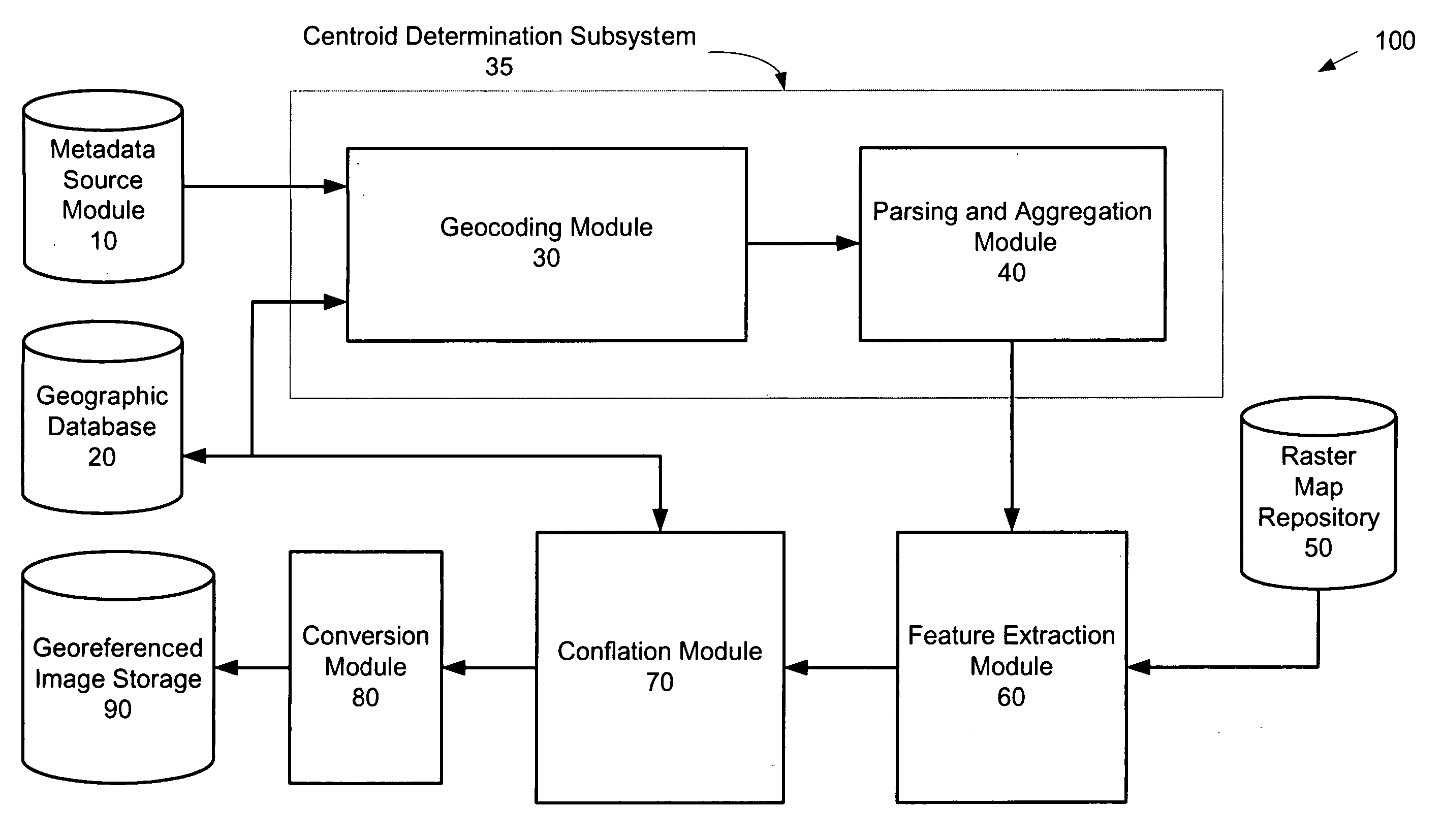
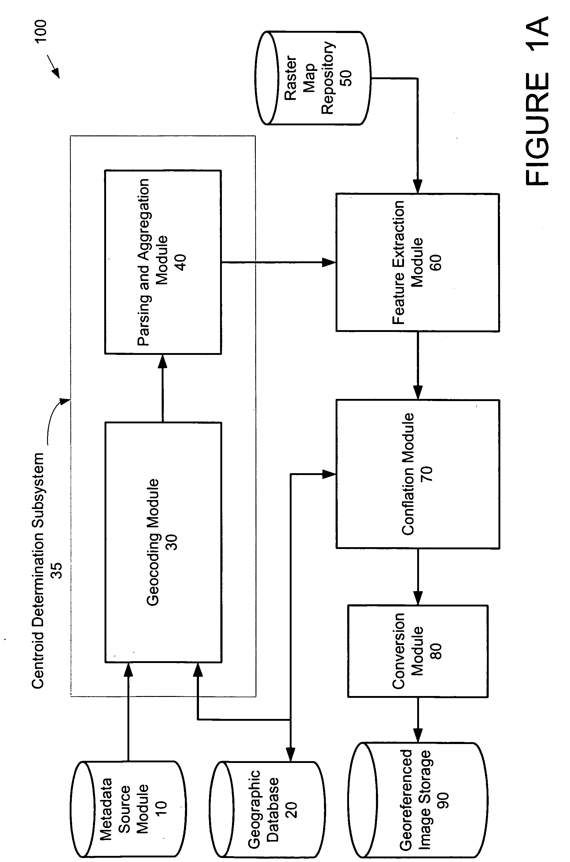
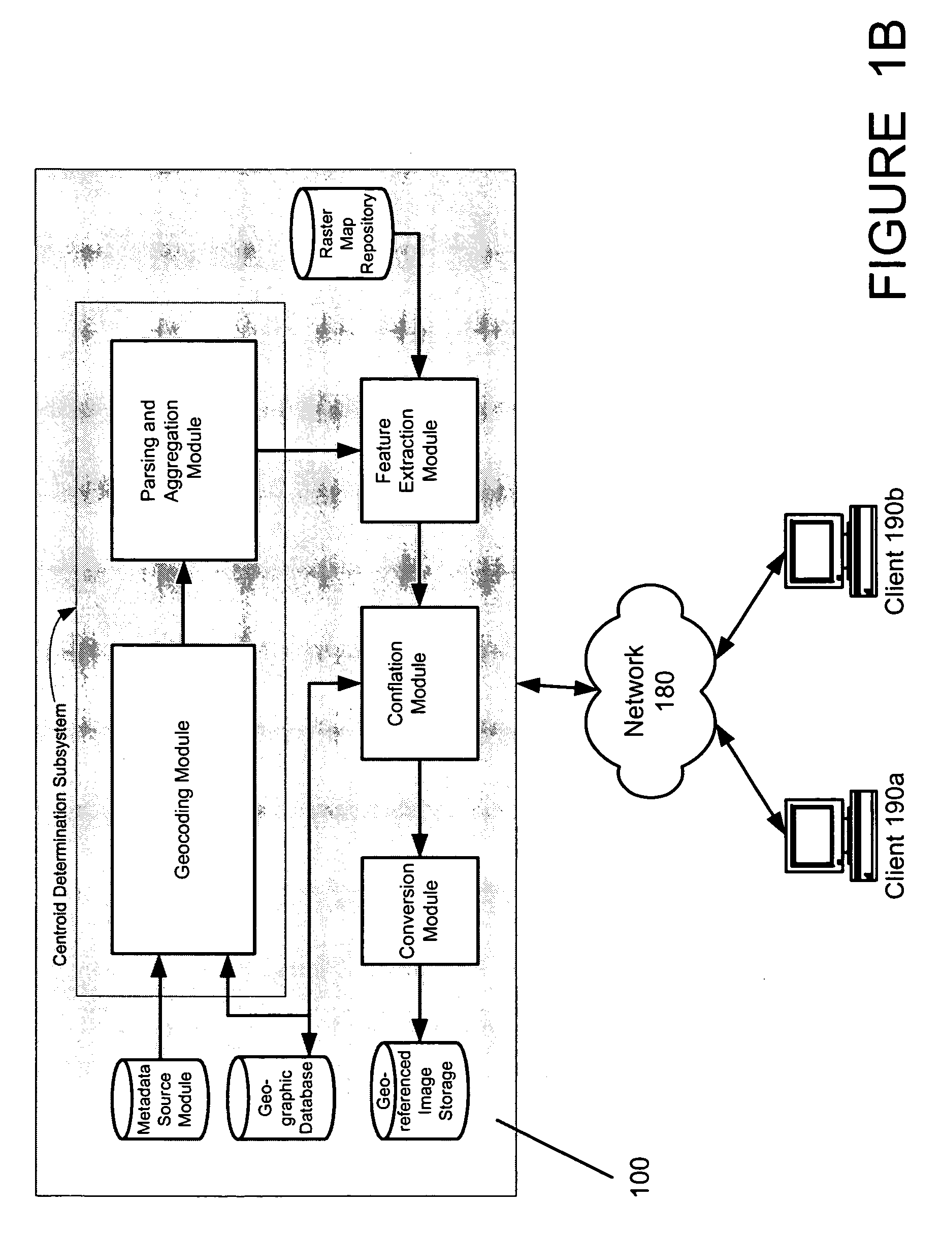
[0039] The present invention extends the functionality of current georeferencing systems by allowing users to automatically generate co-position alignment of geographic target vectors and raster map image data with exceptional accuracy by determining the centroid of the raster map area of coverage prior to extracting information from the raster map data. The present system has many advantages over prior systems such as those requiring extensive operator interaction, because the accurate automated generation of co-registered data permits quick and affordable control of the validation a...


PUM


Abstract

A system and method for automatically georeferencing digitized images selects and analyzes image landmark points from disparate sources for image co-registration. A composite alignment of raster images and geographic target vectors is automatically generated using metadata sources for use in geographic display and editing environments. Cartographic alignment of raster images to geographic vector data sets is performed to co-position image data with geographic vector data sets. The co-registration and display permits a meaningful overlay of the data sets and an improved comparison of vector data to the correctly-registered images based on the physical relationships between the vector data and the underlying image features. By incorporating metadata regarding landmarks and other points of interest, users may query target vectors to display attributes of the associated landmarks and create a highly accurate parcel map for validating image information in areas where the data was acquired in sub-optimal conditions.

Description

BACKGROUND OF THE INVENTION [0001] 1. Technical Field of the Invention [0002] The present invention is directed to a system and method for analyzing geographic features and landmarks such as those used in the generation of maps, atlases, online maps, and navigational systems. In particular, the present invention is directed to a system and method of automatically generating a composite alignment of raster images and geographic target vectors for use in geographic display and editing environments. [0003] 2. Description of Related Art [0004] Many businesses compile geospatial information and maintain geospatial information systems. The geospatial information is gathered from multiple, disparate sources and used to build a unified, coherent database from which geospatial images may be produced. Geospatial information providers acquire the geospatial data and sell the data to a variety of customers that require the information to operate their businesses. For example, geospatial informa...

Claims


Application Information

Patent Timeline
IPC IPC(8): G01C21/30
CPCG01C15/00
Inventor WITMER, ALANHAGAN, JAMESSCAFFIDI, BRIANHANCOCK, JON
Owner TELE ATLAS NORTH AMERICA
Why Eureka
Try Eureka