Method and system for providing location information for emergency services

a technology of location information and emergency services, applied in the field of mobile communications networks, can solve the problems of high cost of providing a wls at each bts, affecting the usefulness of line-of-sight,

Active Publication Date: 2006-05-18
AT&T MOBILITY II LLC
View PDF9 Cites 36 Cited by
  • Summary
  • Abstract
  • Description
  • Claims
  • Application Information

AI Technical Summary

Benefits of technology

[0008] The following presents a simplified summary of the invention in order to provide a basic understanding of some aspects of the invention. This summary is not an extensive overview of the invention. It is not intended to identi...

Problems solved by technology

Satellite-based systems such as Global Positioning System (GPS) provide very good accuracy and availability; however, impediments to line-...

Method used


Image

  • Method and system for providing location information for emergency services
  • Method and system for providing location information for emergency services
  • Method and system for providing location information for emergency services

Examples


Embodiment Construction

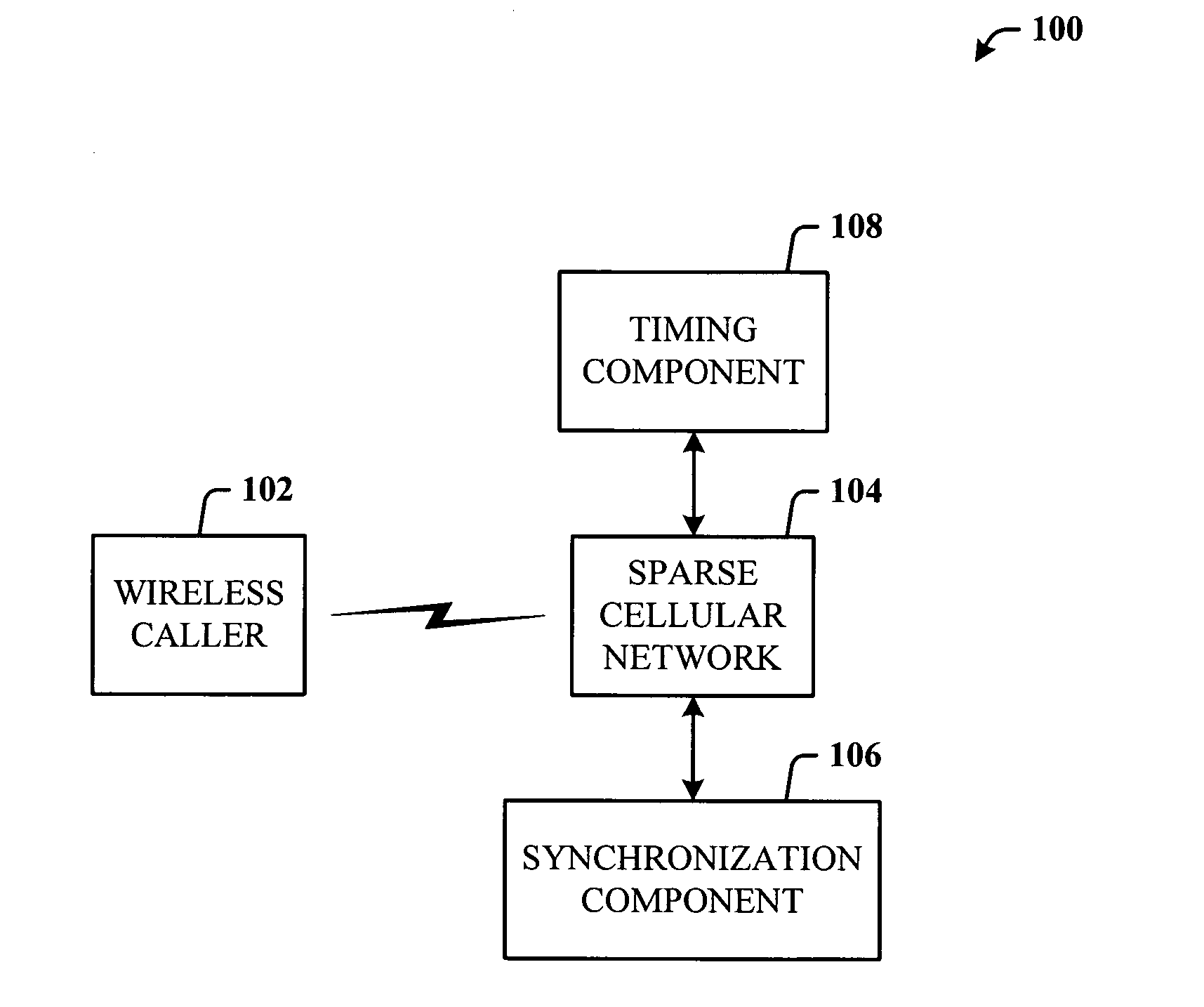
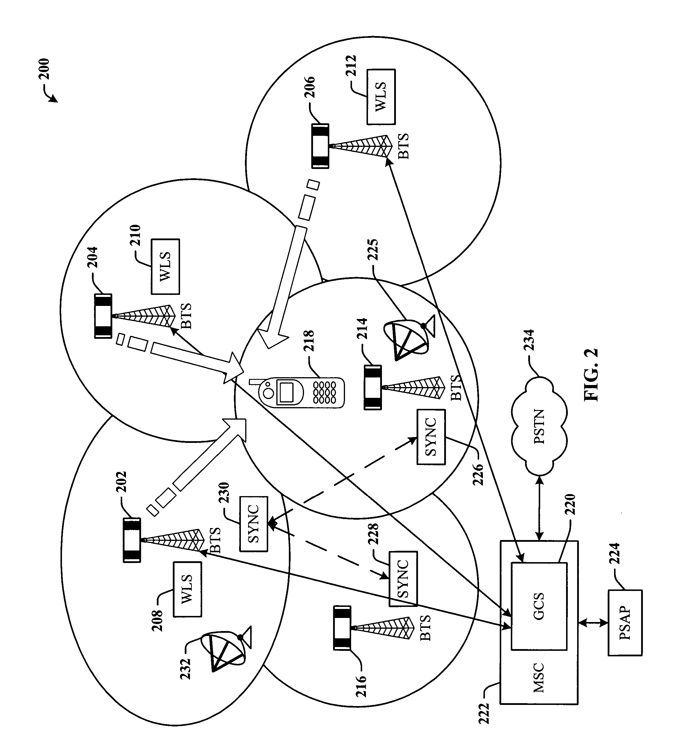
[0022] The invention is now described with reference to the drawings, wherein like reference numerals are used to refer to like elements throughout. In the following description, for purposes of explanation, numerous specific details are set forth in order to provide a thorough understanding of the subject invention. It may be evident, however, that the invention can be practiced without these specific details. In other instances, well-known structures and devices are shown in block diagram form in order to facilitate describing the invention.

[0023] As used in this application, the terms “component” and “system” are intended to refer to a computer-related entity, either hardware, a combination of hardware and software, software, or software in execution. For example, a component can be, but is not limited to being, a process running on a processor, a processor, an object, an executable, a thread of execution, a program, and / or a computer. By way of illustration, both an application...


PUM


Abstract

Emergency Services architecture for determining the location of a wireless caller. The architecture leverages a synchronization feature of GSM networks of the Base Station Subsystem (BSS) to enable employment of sparse networks by removing WLS (Wireless Location Sensor) equipment from selected cell sites. Thus, the location of a wireless caller within a sparse site can be determined. Sparse network location services can be provided further utilizing Time Difference of Arrival (TDOA) technology, and other network-based location technologies such as Enhanced Observed Time Difference (EOTD) and Angle of Arrival (AOA). Hybrid network-based/handset-based location technologies may also be used with the disclosed invention.

Description

TECHNICAL FIELD [0001] This invention is related to mobile communications networks, and more specifically, implementation of emergency services on the mobile communications networks. BACKGROUND OF THE INVENTION [0002] Federal law requires that all Personal Communications System networks and mobile communications networks be capable of providing location information for wireless calls made to emergency services. Under Phase II of the Federal Communications Commission wireless E911 mandate, it is required that technology be in place such that a dispatcher can know more precisely where the caller is located, a capability called Automatic Location Information. [0003] Location technologies can be classified into at least three categories, including stand-alone, satellite-based, and terrestrial-based. A stand-alone system need not rely on multiple range measurements to determine the caller's position, but can attempt to provide the location based on power level, for example. Satellite-bas...

Claims


Application Information

Patent Timeline
IPC IPC(8): H04M11/04H04Q7/20H04W64/00
CPCG01S5/0009G01S5/021G01S5/0263G01S5/04G01S5/06H04W64/00
Inventor BURKE, SCOTT B.
Owner AT&T MOBILITY II LLC
Why Eureka
Try Eureka