Location beacon database

a technology of location beacons and database, applied in the field of location beacon databases, can solve the problems of suboptimal approaches, substantial errors, confusion of receivers, etc., and achieve the effect of avoiding arterial bias

Active Publication Date: 2006-05-18
SKYHOOK WIRELESS
View PDF14 Cites 149 Cited by
  • Summary
  • Abstract
  • Description
  • Claims
  • Application Information

AI Technical Summary

Benefits of technology

[0020] Under another aspect of the invention, a database of Wi-Fi access points for at least one target area having a radius on the order of tens of miles is recorded in a computer-readable medium. It includes database records for substantially all Wi-Fi access points in the target area, each record including identification information for a corresponding Wi-Fi access point and calculated position information for the corresponding Wi-Fi access point, wherein said calculated position information is obtained from recording multiple readings of the Wi-Fi access point to provide reference symmetry when calculating the position of the Wi-Fi access point and to avoid arterial bias in the calculated position information.

Problems solved by technology

Each of these approaches has its strengths and weaknesses based on the radio technology and the positioning algorithms they employ.
Weather, buildings or structures and foliage can cause interference because the receivers require a clear line-of-sight to three or more satellites.
The radio signals from the satellites bounce off physical structures causing multiple signals from the same satellite to reach a receiver at different times. Since the receiver's calculation is based on the time the signal took to reach the receiver, multi-path signals confuse the receiver and cause substantial errors.
Unfortunately these approaches have proven to be suboptimal due to the heterogeneous nature of the cellular tower hardware along with the issues of multi-path signals and the lack of uniformity in the positioning of cellular towers.
These systems have been plagued by slow response times and poor accuracy—greater than 100 meters in downtown areas.
The challenges facing this model are the cost of the new hardware receiver and the limitations of using such a small set of reference points.
For example, if a user is outside the perimeter of towers, the system has a difficult time providing reasonable accuracy.
Since there are no TV towers out in the ocean, there is no way to provide reference symmetry among the reference points resulting in a calculated positioning well inland of the user.
Because individuals voluntarily supply the data the systems suffer a number of performance and reliability problems.
Third, the user-supplied data suffers from arterial bias.
Arterial bias causes a resulting location pull towards main arteries regardless of where the user is currently located causing substantial accuracy errors.
Fourth, these databases include the calculated position of scanned access points rather than the raw scanning data obtained by the 802.11 hardware.
The accuracy requirements for these use cases are very demanding typically calling for 1-3 meter accuracy.
While these systems are becoming more reliable for these indoor use cases, they are ineffective in any wide-area deployment.
It is impossible to conduct the kind of detailed site survey required across an entire city and there is no way to rely on a constant communication channel with 802.11 access points across an entire metropolitan area to the extent required by these systems.
Most importantly outdoor radio propagation is fundamentally different than indoor radio propagation rendering these indoor positioning algorithms almost useless in a wide-area scenario.

Method used


Image

  • Location beacon database
  • Location beacon database
  • Location beacon database

Examples


Embodiment Construction

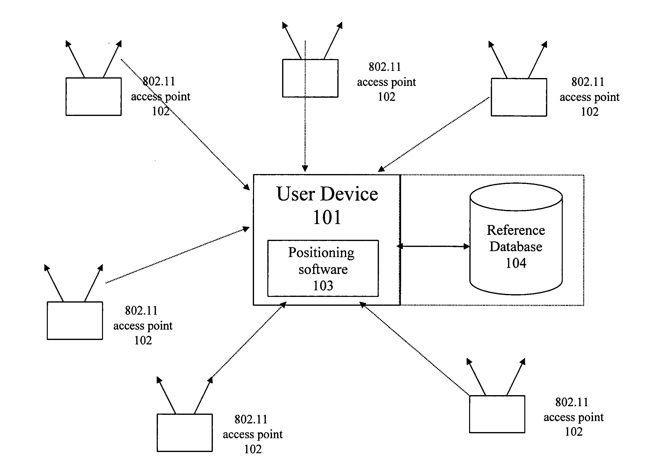
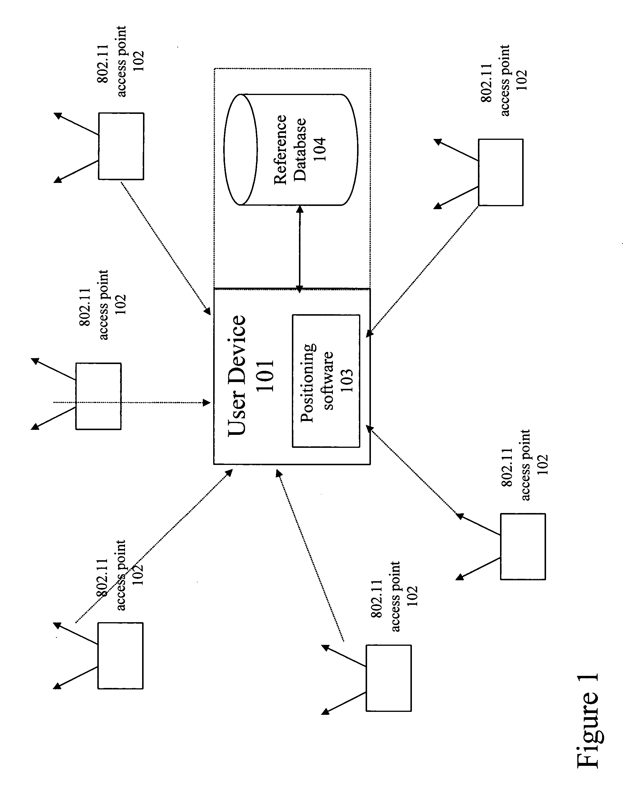
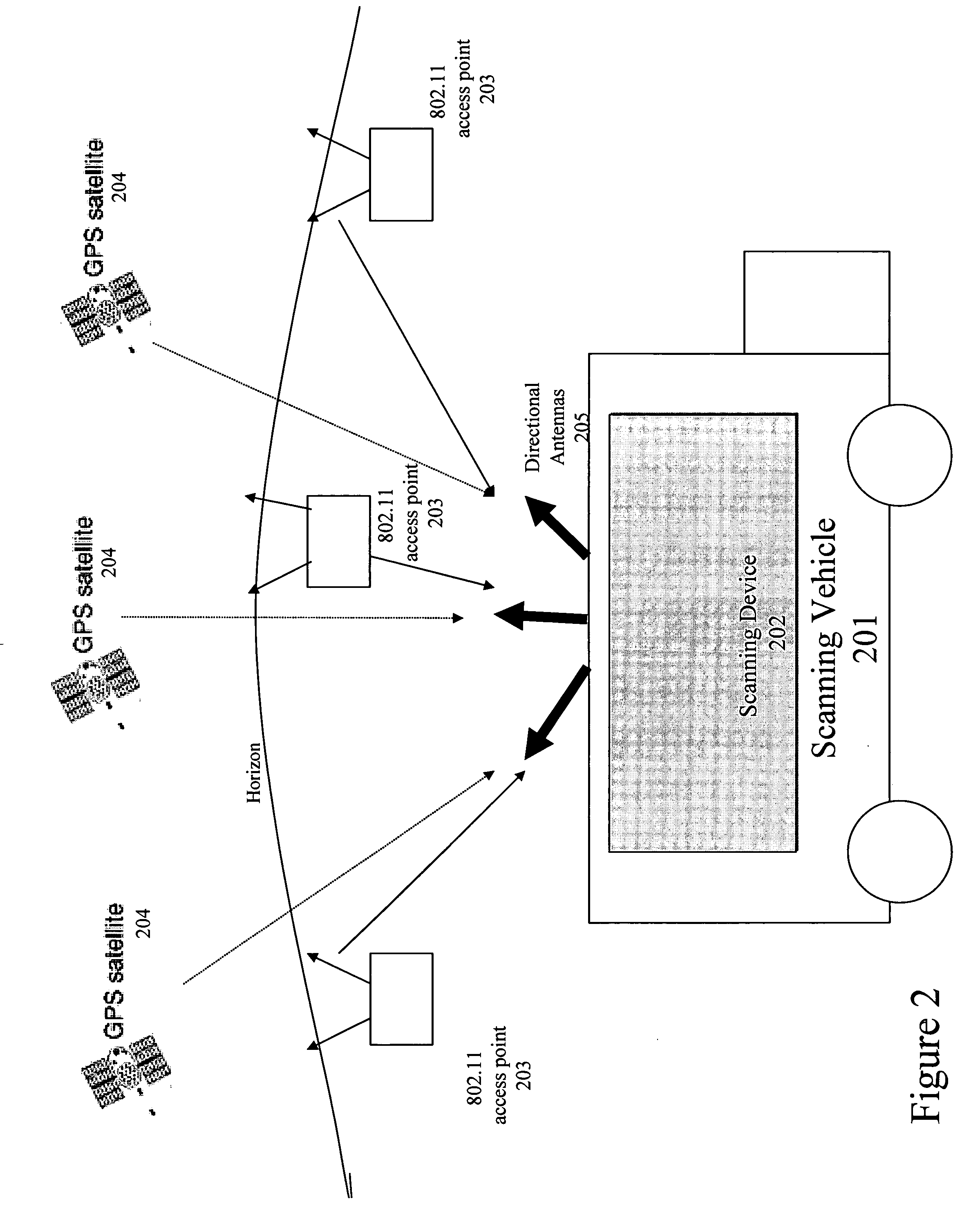
[0033] Preferred embodiments of the present invention provide a system and a methodology for gathering reference location data to enable a commercial positioning system using public and private 802.11 access points. Preferably, the data is gathered in a programmatic way to fully explore and cover the streets of a target region. The programmatic approach identifies as many Wi-Fi access points as possible. By gathering location information about more access points, preferred embodiments not only provide a larger collection of location information about access points, but the location information for each access point may be calculated with more precision. Subsequently this larger set of more precise data may be used by location services to more precisely locate a user device utilizing preferred embodiments of the invention. Certain embodiments use techniques to avoid erroneous data in determining the Wi-Fi positions and use newly-discovered position information to improve the quality ...


PUM


Abstract

A location beacon database and server, method of building location beacon database, and location based service using same. Wi-Fi access points are located in a target geographical area to build a reference database of locations of Wi-Fi access points. At least one vehicle is deployed including at least one scanning device having a GPS device and a Wi-Fi radio device and including a Wi-Fi antenna system. The target area is traversed in a programmatic route to avoid arterial bias. The programmatic route includes substantially all drivable streets in the target geographical area and solves an Eulerian cycle problem of a graph represented by said drivable streets. While traversing the target area, periodically receive the GPS coordinates of the GPS device. While traversing the target area, detecting Wi-Fi signals from Wi-Fi access points in range of the Wi-Fi device and recording identity information of the detected Wi-Fi access point in conjunction with GPS location information of the vehicle when the detection of the Wi-Fi access point was made. The location information is used to reverse triangulate the position of the detected Wi-Fi access point; and the position of the detected access point is recorded in a reference database. A user-device having a Wi-Fi radio may be located. A reference database of calculated locations of Wi-Fi access points in a target area is provided. In response to a user application request to determine a location of a user-device having a Wi-Fi radio, the Wi-Fi device is triggered to transmit a request to all Wi-Fi access points within range of the Wi-Fi device. Messages are received from the Wi-Fi access points within range of the Wi-Fi device, each message identifying the Wi-Fi access point sending the message. The signal strength of the messages received by the Wi-Fi access points is calculated. The reference database is accessed to obtain the calculated locations for the identified Wi-Fi access points. Based on the number of Wi-Fi access points identified via received messages, choosing a corresponding location-determination algorithm from a plurality of location-determination algorithms, said chosen algorithm being suited for the number of identified Wi-Fi access points. The calculated locations for the identified Wi-Fi access points and the signal strengths of said received messages and the chosen location-determination algorithm are used to determine the location of the user-device. The database may be modified with newly added position information to improve quality of previously determined positions, and error prone information is avoided.

Description

CROSS-REFERENCE TO RELATED APPLICATIONS [0001] This application claims the benefit under 35 U.S.C. § 19(e) of U.S. Provisional Patent Application No. 60 / 623,108, filed on Oct. 29, 2004, entitled Wireless Data Scanning Network for Building Location Beacon Database, which is herein incorporated by reference in its entirety. [0002] This application is related to the following U.S. Patent Applications (Nos. TBA), filed on an even date herewith, entitled as follows: [0003] Server for Updating Location Beacon Database; [0004] Location-Based Services that Choose Location Algorithms Based on Number of Detected Access Points Within Range of User Device; and [0005] Method and System for Building a Location Beacon Database.BACKGROUND [0006] 1. Field of the Invention [0007] The invention generally related to location-base services and, more specifically, to methods and systems of determining locations of Wi-Fi access points and using such information to locate a Wi-Fi-enabled device. [0008] 2. ...

Claims


Application Information

Patent Timeline
Patent Type & Authority Applications(United States)
IPC IPC(8): G06F17/00G06F7/00G01S19/48H04W4/02H04W4/029H04W48/08H04W64/00
CPCG01S5/02H04W88/06G01S5/021G01S5/0226G01S5/0242G01S5/0252G01S5/0284G01S19/14G01S19/46G06Q10/0875G08G1/20H04W16/18H04W48/08H04W48/16H04W64/00H04W64/003H04W84/10H04W24/00Y10S707/99936H04W4/02H04W88/08G01S5/0205G01S5/02526G01S19/13H04W4/029H04W84/12
Inventor MORGAN, EDWARD J.ALIZADCH-SHABDIZ, FARSHIDJONES, RUSSEL K.SHEAN, MICHAEL G.
Owner SKYHOOK WIRELESS
Why Eureka
Try Eureka