Navigation service method and terminal of enabling the method

a technology of navigation service and terminal, applied in the field of navigation service, can solve the problems of difficult to quickly cope with the transformation of a topographical object, complicated, and took a very long time, and achieve the effect of effectively using a database, quick readjusting to the transformation of a topographical image, and reducing the burden of maintenance and repair

Inactive Publication Date: 2006-06-29
ENGIS TECH
View PDF9 Cites 42 Cited by
  • Summary
  • Abstract
  • Description
  • Claims
  • Application Information

AI Technical Summary

Benefits of technology

[0025] The present invention utilizes an aerial photograph or a satellite photograph, a topographical image, and an illustrated map image as background data in the form of a layer and quickly readjusting to the transformation of a topographical image. Also, the present invention red

Problems solved by technology

The P code is limited to military use because of agreements between governments.
However, the aforementioned technology of Japan's Fujitsutensa had to add image data about a satellite photograph to existing geographic data.
Namely, it was difficult to quickly cope with the

Method used


Image

  • Navigation service method and terminal of enabling the method
  • Navigation service method and terminal of enabling the method
  • Navigation service method and terminal of enabling the method

Examples


Embodiment Construction

[0038] Hereinafter, an embodiment of the present invention will be described in detail with reference to the accompanying drawings.

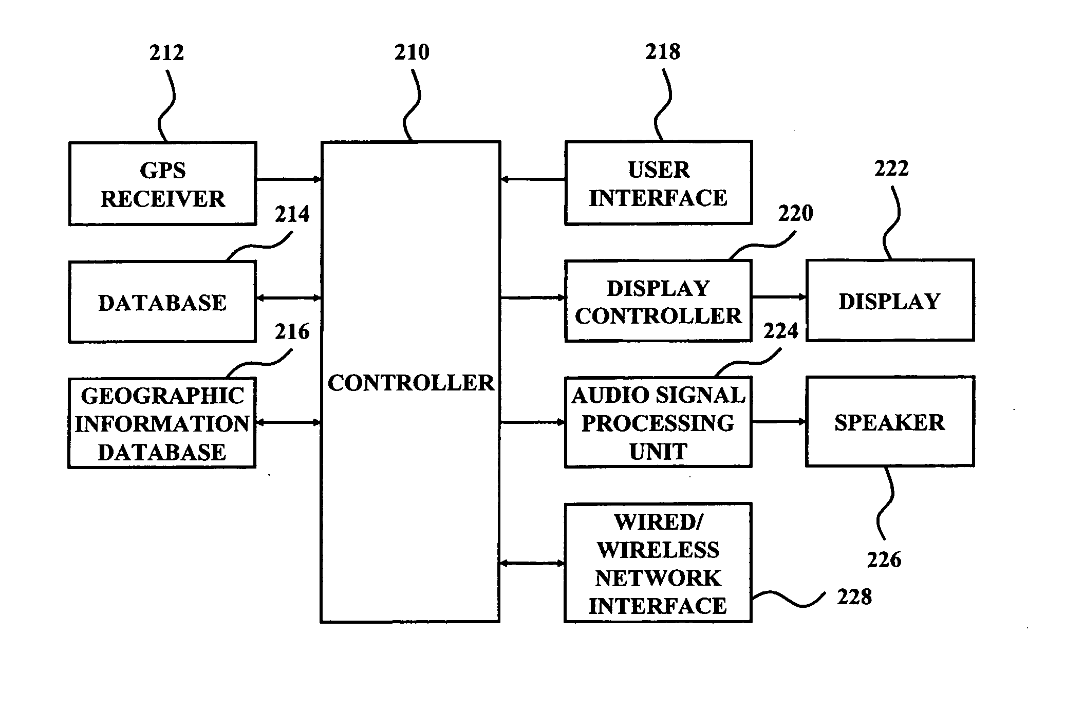
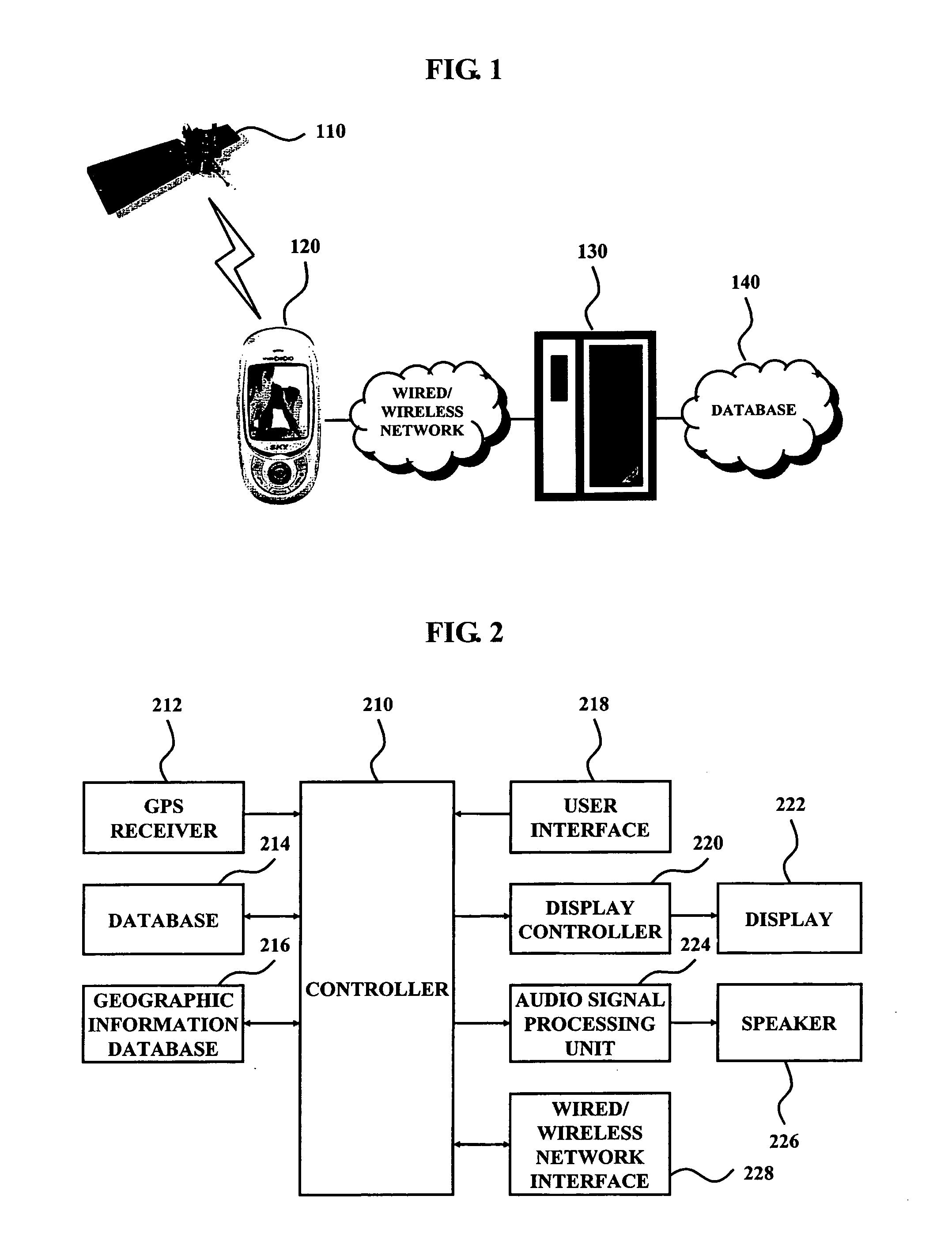
[0039]FIG. 1 is a configuration diagram illustrating a navigation service system according to an exemplary embodiment of the present invention.

[0040] Referring to FIG. 1, a GPS (Global Positioning System) satellite 110 transmits various codes for calculating a position. A navigation service terminal 120 receives various codes transmitted from the GPS satellite 110, calculates a current position, and informs a user of the current position by using embedded geographic data or calculates a route to a position requested by the user and guides the user through the calculated route. The navigation service terminal 120 accesses a navigation service server 130 via a wired / wireless network, downloads updated geographic data, and updates embedded geographic data. The navigation service server 130 constructs geographic data according to an exemplary embodiment of...


PUM


Abstract

Disclosed is a navigation service method using geographic information, comprising the steps of: storing geographic data in a database, the geographic data including network data for indicating geographic coordinates, calculating a route, and matching a GPS (Global Positioning System) code received from GPS satellites and the geographic coordinates, point data having position information for a search, and background data that is an aerial photograph or a satellite photograph; searching for a desired position or calculating a current position according to a GPS code in the case of receiving the GPS code from the GPS satellites; loading background data and map data about a predetermined area including the current position from the database; and generating map image data overlapping the loaded map data and background data and displaying the generated map image data to a display.

Description

CROSS-REFERENCE TO RELATED APPLICATIONS [0001] This application claims the benefit of Korean Patent Application No. 2004-113362, filed on Dec. 27, 2004, in the Korean Intellectual Property Office, the disclosure of which is incorporated herein in its entity by reference. BACKGROUND OF THE INVENTION [0002] 1. Field of the Invention [0003] The present invention relates to a navigation service, and more particularly, to a navigation service method capable of using an aerial photograph or a satellite photograph as background data and a terminal of enabling the method. [0004] 2. Description of the Related Art [0005] A GPS (Global Positioning System) is a worldwide position determining system using satellites. A navigation system uses a GPS receiver to receive radio waves transmitted from a satellite to determine an exact position, determines how long it takes to reach a target location, and determines a route to the target place. [0006] The GPS method of determining a position uses four-...

Claims


Application Information

Patent Timeline
IPC IPC(8): G01C21/28
CPCG01C11/02G01C21/28
Inventor PARK, YONG SUN
Owner ENGIS TECH
Why Eureka
Try Eureka