Electromagnetic surveying for resistive or conductive bodies

a technology of resistive or conductive bodies and electromagnetic surveying, which is applied in the direction of reradiation, detection using electromagnetic waves, instruments, etc., can solve the problems of significant error in interpreting data, difficult to accurately do this, and generally not providing good results for surveys

Active Publication Date: 2006-08-24
PGS GEOPHYSICAL AS
View PDF3 Cites 63 Cited by
  • Summary
  • Abstract
  • Description
  • Claims
  • Application Information

AI Technical Summary

Benefits of technology

[0021] In this case, references to horizontal indicate that a significant component, preferably a major component, of the respective signals should be aligned with the horizontal axes. It is not necessary that the signals are perfectly aligned to the horizontal axes, although close alignment is preferred to provide a strong signal and reduce the complexity of analysis, for example alignment within + / −30° is desirable.
[0025] By generating combined response data in the analysis, it is possible to analyze survey results taken in shallower water than has previously been possible. This is because the combined response data are less sensitive to transverse electric (TE) mode components which have propagated through air and which tend to dominate survey results analyzed with previous methods.
[0026] Combined response data of this kind are functionally similar to vertical derivatives in vertical components of electromagnetic field data. Accordingly, the combined response data provide similar benefits to those achievable with data from vertical electric field detectors, such as the benefits described in GB 2402745 A [10]. However, with the present invention, these advantages are achieved without relying on vertical electromagnetic field measurements. This is beneficial because, as noted above, vertical field measurements can be more susceptible to noise, particularly motion-induced noise caused by undersea water currents.
[0027] Furthermore, the combined response data are independent of the orientation of the first and second directions with respect to the transmitter dipole. This means it is not necessary to know the orientation of receivers used to collect the data from which the combined response data are derived.
[0031] This can be beneficial since the comparison of the combined response data with background data can help to determine whether features of the combined response data are indicative of a resistive or conductive body or arise as a result of some other local background structure configuration. Background data may be obtained by modeling the EM survey performed to obtain the combined response data with a model background subterranean strata configuration. The background model strata configuration should preferably be a close match to the actual background structure in the area being surveyed.

Problems solved by technology

However, sole reliance on the sensitivity of the TM mode components to the presence of a thin resistive layer can lead to ambiguities.
However, it can be difficult to do this accurately which can lead to a significant source of error when interpreting data.
A problem with the above described survey and analysis techniques is that they do not generally provide good results for surveys made in shallow waters.
The TM mode components, on the other hand, do not couple well across this boundary and consequently do not contribute significantly to the airwave component.
The existence of the airwave as a dominant component of the detector signals limits the applicability of the above described surveying and analysis techniques.
This not only leads to a need to employ more receiver locations to adequately cover a given area, but also limits the depth beneath the seafloor to which the technique is sensitive.
This can mean that a buried hydrocarbon reservoir in shallow water may not be detectable, even though the same reservoir would be detected in deeper water.
It is apparent that the airwave significantly limits the usefulness of these surveying and analysis techniques in shallow water.
As a consequence deep target detection becomes impossible.
However, in practice there can be difficulties with this approach in practical surveys.
This is because measurements of vertical electric field are significantly more prone to motion induced noise than more conventional measurements of horizontal components.

Method used


Image

  • Electromagnetic surveying for resistive or conductive bodies
  • Electromagnetic surveying for resistive or conductive bodies
  • Electromagnetic surveying for resistive or conductive bodies

Examples


Embodiment Construction

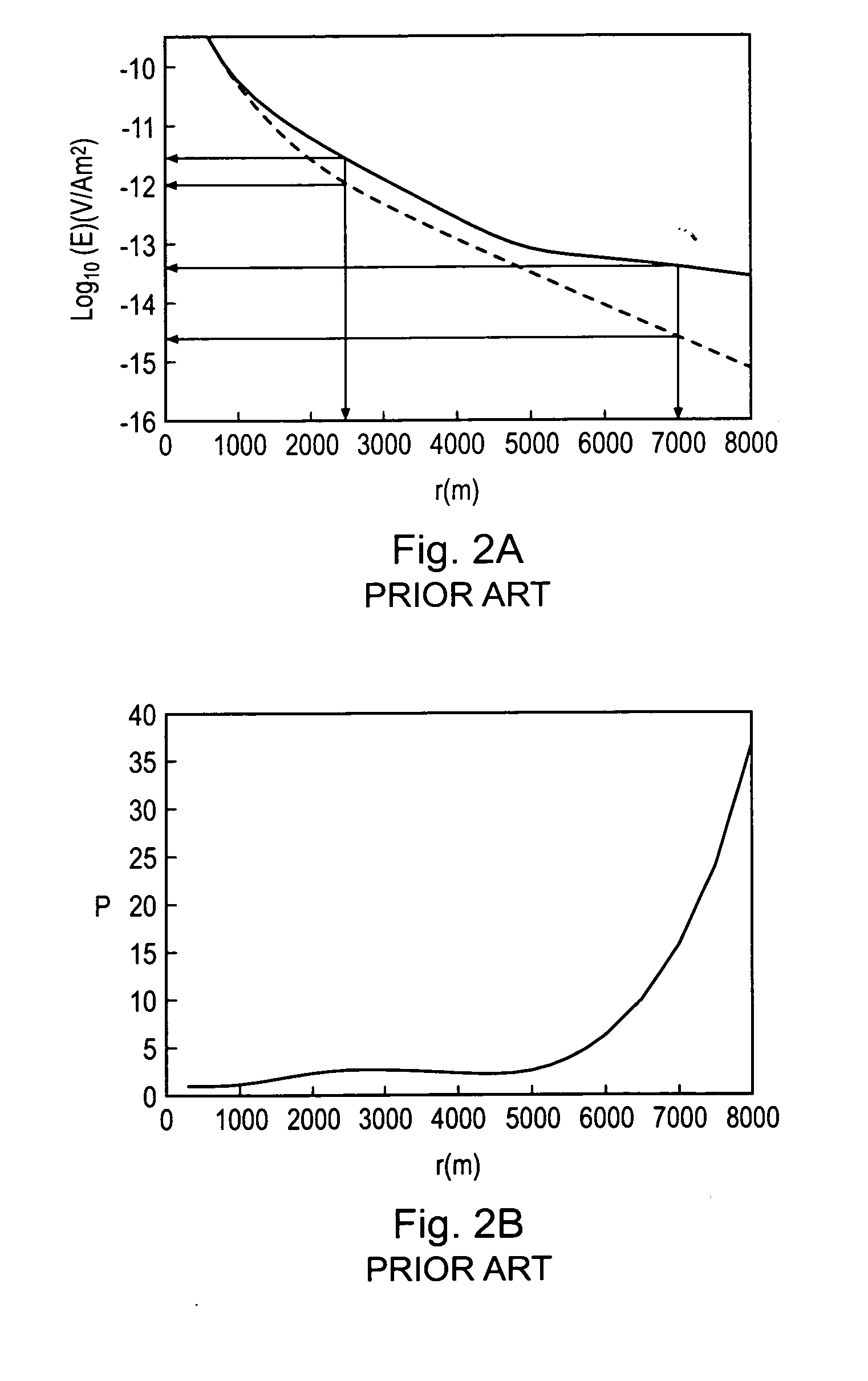
[0110]FIG. 4 is a schematic plan view showing a co-ordinate system for describing the relative placement of an HED transmitter 22 and a receiver 25 of the kind shown in FIG. 1. The position of the receiver 25 with respect to the HED transmitter 22 is most suitably described in cylindrical polar co-ordinates, with the center of the HED transmitter 22 providing the origin of the co-ordinate system. The position of the receiver 25 is defined by an azimuthal angle φ and a separation distance (or range) r. The angle φ is measured clockwise from a line passing through, and running parallel to, the HED transmitter axis, as indicated in FIG. 4 by the line marked φ=0°. A receiver placed along this line, i.e. such that is has an azimuthal angle φ of 0°, is referred to as being in an inline or end-on position. A receiver with an azimuthal angle φ of 90°, such that it lies on the line marked φ=90° in FIG. 4, is referred to as being in a broadside position. The electric field at a receiver may b...


PUM


Abstract

A method of analyzing electromagnetic survey data from an area of seafloor 6 that is thought or known to contain a resistive or conductive body, for example a subterranean hydrocarbon reservoir 12, is described. The method includes providing horizontal electromagnetic field data obtained by at least one receiver 125 from at least one horizontal electric dipole transmitter 22. Horizontal gradients in the electromagnetic field data are determined for a first component of the electromagnetic field data along a first direction and for a second component of the electromagnetic field data along a second direction. The first and second components can be the electric field along the first and second directions, or the magnetic field perpendicular to the first direction and second directions. The gradients are then combined to provide combined response data. Because the combined response data are relatively insensitive to the transverse electric (TE) mode component of the transmitted signal, the method allows hydrocarbon reservoirs to be detected in shallow water where the TE mode component interacting with the air would otherwise dominate.

Description

BACKGROUND OF THE INVENTION [0001] The invention relates to seafloor electromagnetic surveying for resistive and / or conductive bodies, for example for oil and other hydrocarbon reserves or subterranean salt bodies. [0002]FIG. 1 schematically shows a surface vessel 14 undertaking controlled source electromagnetic (CSEM) surveying of a subterranean strata configuration using standard techniques [1]. The subterranean strata configuration in this example includes an overburden layer 8, an underburden layer 9 and a hydrocarbon reservoir 12. The surface vessel 14 floats on the surface 2 of a body of water, in this case seawater 4 of depth h meters. A submersible vehicle 19 carrying a source in the form of a horizontal electric dipole HED transmitter 22 is attached to the surface vessel 14 by an umbilical cable 16. This provides an electrical and mechanical connection between the submersible vehicle 19 and the surface vessel 14. The HED transmitter is supplied with a drive current so that ...

Claims


Application Information

Patent Timeline
Patent Type & Authority Applications(United States)
IPC IPC(8): G01V3/08G01V3/12
CPCG01V3/083G01V3/12Y02A90/30G01V3/38
Inventor ANDREIS, DAVID
Owner PGS GEOPHYSICAL AS
Why Eureka
Try Eureka