Electromagnetic surveying for hydrocarbon reservoirs

a hydrocarbon reservoir and electromagnetic surveying technology, applied in the field of seafloor electromagnetic surveying, can solve the problems of difficult to distinguish between the different possible compositions of pore fluids within, expensive process, and no reward guarantee, and achieve the effect of thorough data analysis

Inactive Publication Date: 2008-02-26
OHM
View PDF15 Cites 30 Cited by
  • Summary
  • Abstract
  • Description
  • Claims
  • Application Information

AI Technical Summary

Benefits of technology

[0021]In this case, references to vertical and horizontal indicate that a significant component, preferably a major component, of the respective signals should be aligned with the vertical and horizontal axes. It is not necessary that the signals are perfectly, or even closely, aligned to the vertical and horizontal axes, although fairly close alignment is preferred to provide a strong signal and reduce the complexity of analysis, for example alignment within + / −30° is desirable.
[0024]Most preferably, the VED source and VMD source are part of a single submersible tow vehicle and the collection of the first and second survey data sets is done concurrently, typically by towing the vehicle over the seafloor along a predefined survey path. During surveying, the tow vehicle can be switched at short intervals between activation of the VED source and the VMD source. Alternatively, the VED and VMD sources can be operated simultaneously at different frequencies to allow easy separation of the two signals at the detectors. In either case, the complete survey can be carried out with a single tow, i.e. both the first and second survey data sets can be obtained concurrently. In contrast, in previously proposed EM survey methods based on use of a survey vehicle with a HED antenna, two sets of survey data had to be obtained with different tows over different paths in order to probe the response of an area of interest galvanically and inductively. Being able to collect the first and second survey data sets concurrently is of great practical advantage, since it obviates the need to perform two separate tows over different survey paths.
[0026]Since a VED antenna generates electromagnetic field configurations which are sensitive to the presence of a thin resistive layer, whereas a VMD generates electromagnetic field configurations which are sensitive to the background structure, by operating the VED and VMD antennae at different frequencies, or consecutively at the same frequency, the galvanically and inductively coupled modes of current transfer can be easily separated, so avoiding the difficulty of the ‘mixed-mode’ fields generated in previously proposed survey methods.
[0027]Furthermore, the vertical electromagnetic signal induces significant components of electric current which are normal to a surface of a body of water in which the electromagnetic survey is performed. This limits the deleterious effects of the finite seawater depth compared to those seen in previously proposed electromagnetic survey methods. The vertical electromagnetic signal can therefore be operated in shallower water than has previously been possible and allows electromagnetic surveying to be performed in areas which have not previously been amenable to electromagnetic surveying.
[0028]If the first survey data set is obtained by towing a source of the vertical electromagnetic signal along a tow-path relative to an array of detectors within the area of interest, a comprehensive survey can be performed rapidly. Furthermore, because patterns of current flow induced by vertical electric dipole (and vertical magnetic dipole) electromagnetic signals are cylindrically symmetric, detector data can be consistently and reliably collected from all detectors within the array for all source locations. This has not been possible with previously proposed survey methods for which data can only be reliably collected for specific relative orientations of the source and detector. Furthermore, if the layers comprising the subterranean strata are largely homogeneous and isotropic, the circular symmetry of the vertical electromagnetic signal can obviate the need to determine the orientation of the detectors within the area of interest. In cases where the layers comprising the subterranean strata are not homogeneous and isotropic, knowledge of the detector antenna orientation, for instance measured by a compass, will allow more thorough data analysis to be performed.

Problems solved by technology

Whilst seismic surveying is able to identify such structures, the technique is often unable to distinguish between the different possible compositions of pore fluids within them, especially for pore fluids which have similar mechanical properties.
However, this is an expensive process, and one which provides no guarantee of reward.
However, for deep-sea surveys, all but those MT signals with periods corresponding to several cycles per hour are screened from the seafloor by the highly conductive seawater: Whilst the long wavelength signals which do penetrate to the seafloor can be used for large scale undersea probing, they do not provide sufficient spatial resolution to examine the electrical properties of the typically relatively small scale subterranean reservoirs.
Moreover, since MT surveying relies primarily on horizontally polarised EM fields, it is intrinsically insensitive to thin resistive layers.
However, sole reliance on the sensitivity of vertical current flow components to the presence of a thin resistive layer can lead to ambiguities.
However, some limitations of the method have been identified.
Firstly, since the two modes cannot be easily separated there will generally be a level of cross-talk between them at a detector and this can lead to ambiguities in the results.
This requires the surface vessel to make multiple passes over broadcast locations and can lead to complex and long tow patterns.
Thirdly, a HED antenna based EM survey can only provide the best data possible at discrete survey locations.
At other orientations, separation of the inductively and galvanically coupled signals becomes more much difficult and data are less reliable.

Method used


Image

  • Electromagnetic surveying for hydrocarbon reservoirs
  • Electromagnetic surveying for hydrocarbon reservoirs
  • Electromagnetic surveying for hydrocarbon reservoirs

Examples


Embodiment Construction

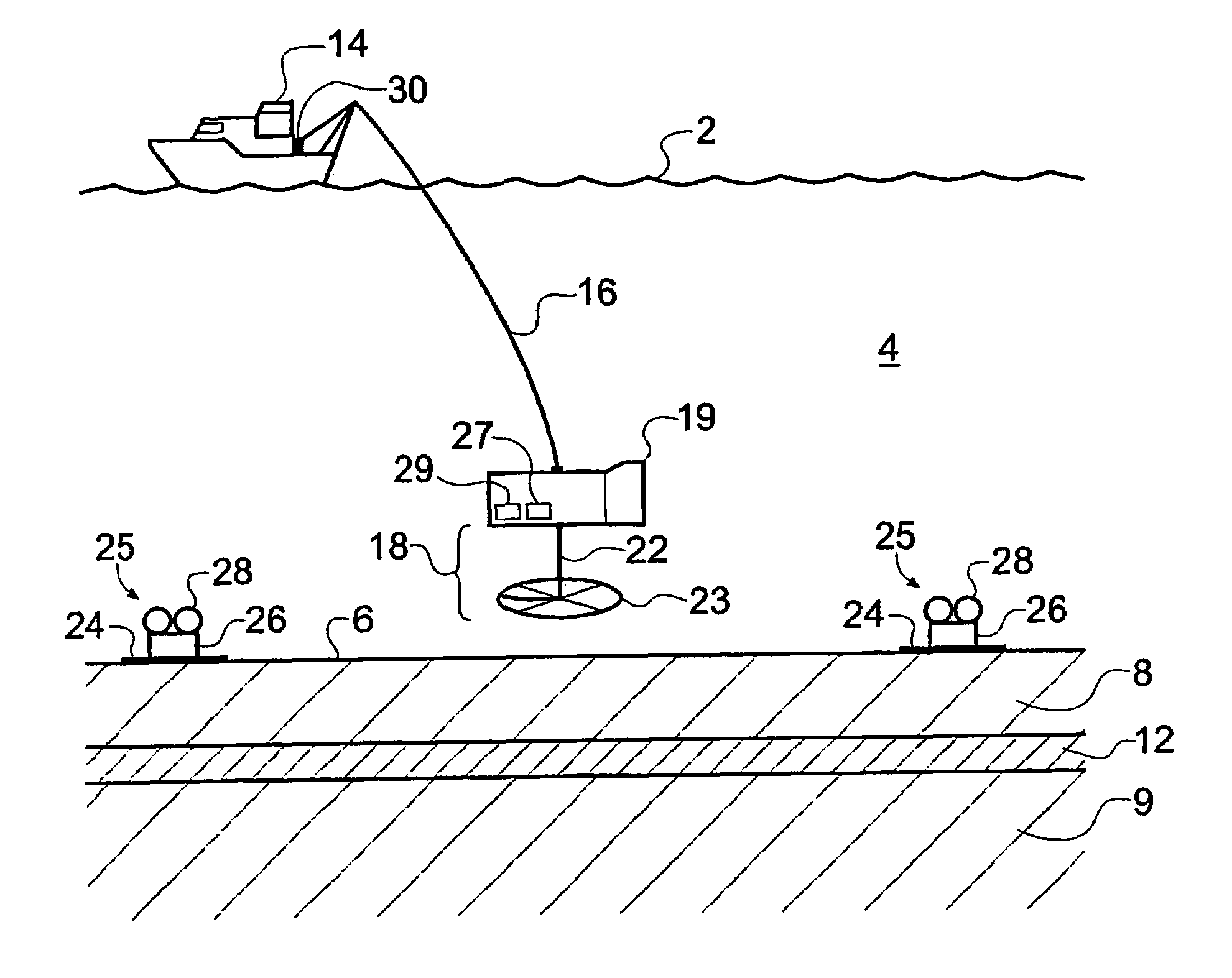
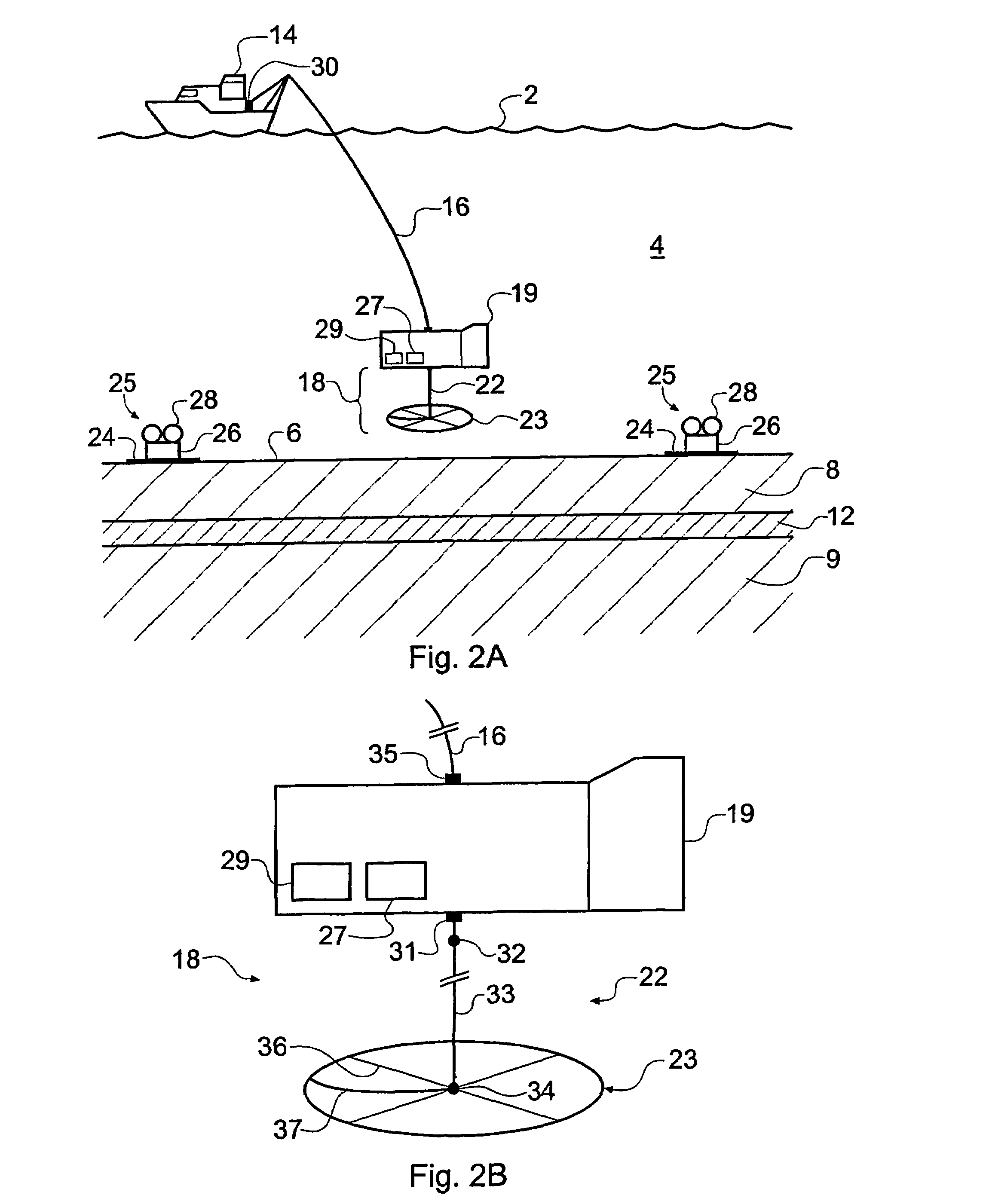
[0077]FIG. 2a of the accompanying drawings schematically shows a surface vessel 14 undertaking EM surveying of a subterranean strata configuration (or rock formation) according to an embodiment of the invention. Features shown in FIG. 2a which are functionally similar to features shown in FIG. 1a are given the same reference numeral but shall be described again for the sake of completeness. The subterranean strata configuration includes an overburden layer 8, an underburden layer 9 and a hydrocarbon layer (or reservoir) 12. The surface vessel 14 floats on the surface 2 of the seawater 4. A deep-towed submersible vehicle 19 carrying an EM source 18 is attached to the surface vessel 14 by an umbilical cable 16 providing a detachable electrical and mechanical connection between the deep-towed submersible vehicle 19 and the surface vessel 14. The deep-towed vehicle 19 includes an echo location package 27 which assists in maintaining the EM source 18 at an appropriate height above the se...


PUM


Abstract

An electromagnetic survey method for surveying an area of seafloor that is thought or known to contain a subterranean hydrocarbon reservoir, comprising obtaining a first survey data set with a vertical electric dipole (VED) antenna for generating vertical current loops and a second survey data set with a vertical magnetic dipole (VMD) antenna for generating horizontal current loops. In an alternative embodiment, the VMD antenna is dispensed with and the horizontal electromagnetic field is derived from the naturally occurring magnetotelluric (MT) electromagnetic field. In another alternative embodiment, the VED data is compared with a background geological model instead of VMD or MT data. The invention also relates to a survey apparatus comprising VED and VMD antennae, to planning a survey using this method, and to analysis of survey data taken using this survey method. The first and second survey data sets allow the galvanic contribution to the detector signals collected at a detector to he independently contrasted with the inductive effects. This is important to the success of using electromagnetic surveying for identifying hydrocarbon reserves and distinguishing them from other classes or structure.

Description

[0001]This application is a national phase of International Application No. PCT / GB2003 / 002379 filed May 30, 2003 and published in the English language.BACKGROUND OF THE INVENTION[0002]The invention relates to seafloor electromagnetic surveying for oil and other hydrocarbon reserves.[0003]Determining the response of the sub-surface strata within the earth's crust to electromagnetic fields is a valuable tool in the field of geophysical research. The geological structures associated with thermally, hydrothermally, tectonically or magmatically active regions can be studied. In addition, electromagnetic surveying, or sounding, techniques can provide valuable insights into the nature, and particularly the likely hydrocarbon content, of subterranean reservoirs in the context of subterranean oil exploration and surveying.[0004]Seismic techniques are often used during oil exploration to identify the existence, location and extent of reservoirs in subterranean rock strata. Whilst seismic surv...

Claims


Application Information

Patent Timeline
Patent Type & Authority Patents(United States)
IPC IPC(8): G01V11/00G01V3/12G01V3/15
CPCG01V3/083G01V3/12
Inventor MACGREGOR, LUCY M.RUST, JENNIFER L.SINHA, MARTIN C.
Owner OHM
Why Eureka
Try Eureka