Close-packed uniformly adjacent, multiresolutional overlapping spatial data ordering

a spatial data and spatial data technology, applied in the field of methods and digital information systems, can solve the problems of large global information volume, large global geospatial data storage volume, and inability to form uniform cells, etc., and achieve the effect of efficient computational storage, retrieval and integration

Active Publication Date: 2006-11-23
12995514 CANADA INC
View PDF16 Cites 83 Cited by
  • Summary
  • Abstract
  • Description
  • Claims
  • Application Information

AI Technical Summary

Benefits of technology

[0043] Embodiments of the invention include an on-line Discrete Global Grid System featuring hexagonally gridded data for efficient computational storage, retrieval, integration, transmission, visual display, analysis, fusion, and modeling.

Problems solved by technology

As space, airborne and ground-based sensors increase in number and sophistication; there is a rapid, and potentially unlimited, growth of global information characterizing these environmental systems.
A similar condition produces significant difficulties in global geospatial data storage.
Traditional geographic coordinate systems, latitude and longitude, do not form uniform cells and therefore are not idealized for use where uniformity of cells is assumed or is beneficial.
Merging geospatial information of disparate sources, accuracies, precisions, and formats is complex.

Method used


Image

  • Close-packed uniformly adjacent, multiresolutional overlapping spatial data ordering
  • Close-packed uniformly adjacent, multiresolutional overlapping spatial data ordering
  • Close-packed uniformly adjacent, multiresolutional overlapping spatial data ordering

Examples


Embodiment Construction

Apparatus and Operating Environment

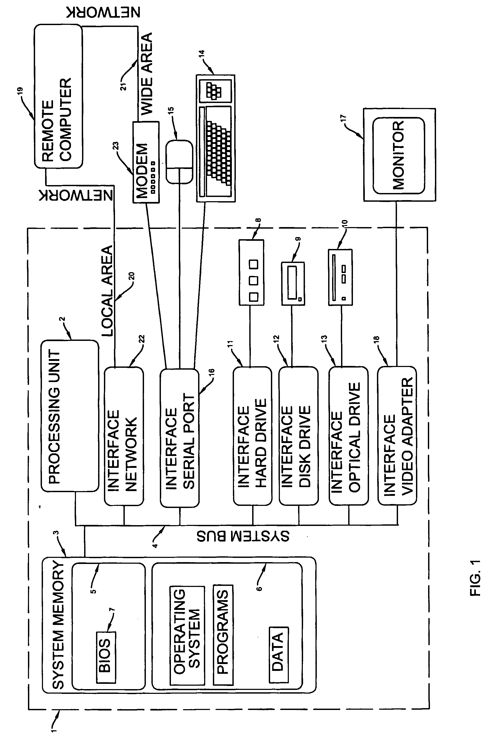
[0055]FIG. 1 is a diagram of the apparatus and operating environment in conjunction with which embodiments of the invention may be practiced. The description of FIG. 1 is intended to provide a brief general description of suitable computer apparatus in conjunction with which the invention may be implemented. The computer, in conjunction with which embodiments of the invention may be practiced, may be a conventional computer, a distributed computer, an embedded computer or any other type of computer; the invention is not so limited. Such a computer typically includes one or more processing units as its processor, and a computer-readable medium such as a memory. The computer may also include a communications device such as a network adapter or a modem, so that it is able to communicatively couple other computers.

[0056] Although not required, the invention is described in the general context of computer-executable instructions being executed by a c...


PUM


Abstract

A method, apparatus, system and data structure is disclosed for mapping of spatial data to linear indexing for efficient computational storage, retrieval, integration, transmission, visual display, analysis, fusion, and modeling. These inventions are based on plane space being decomposed into uniform discrete closely packed (hexagonal) cell areas (85). Each resolution of closely packed cells can be further divided into congruent but denser clusters of closely packed cells. The spatial indexing (86) is applied in such a manner as to build a relationship with the spatially close cells of any resolution.

Description

FIELD OF THE INVENTION [0001] The invention refers generally to methods and digital information systems that represent visual images of planar or near planar space. More particularly, the methods and systems pertain to images that are referenced to earth. BACKGROUND OF THE INVENTION REFERENCES [0002]US Patents: 4691291September, 1987Wolfram364 / 717.US Patents: 4809202February, 1989Wolfram364 / 578.[0003] Dutton, G., 1990, “Locational Properties of Quaternary Triangular Meshes”, Proceedings of the Spatial Data Handling Symposium, Dept. of Geography, U. of Zurich, July 1990, p. 901-910. [0004] Gibson, Laurie and Dean Lucas, “Spatial Data Processing Using Generalized Balanced Ternary”, Proceedings of the IEEE Computer Society Conference on Pattern Recognition and Image Processing, June 1982, p. (56)6-571 [0005] Koch, Niels Fabian Helge von, Une methode geometrique elementaire pour l'etude de certaines questions de la theorie des courbes plane, 1904 [0006] Panu, U. S. and P. R. Peterson (1...

Claims


Application Information

Patent Timeline
Patent Type & Authority Applications(United States)
IPC IPC(8): G06F17/10G06F12/00G06F17/30G06F17/40G06T7/00G06T9/00G06T9/40H04N7/26H04N7/46
CPCG06F17/30241H04N19/59H04N19/96G06T9/40G06F16/29
Inventor PETERSON, PERRY
Owner 12995514 CANADA INC
Why Eureka
Try Eureka