Method and arrangements relating to satellite-based positioning

a satellite-based positioning and positioning method technology, applied in the field of satellite-based positioning, can solve the problems of significant error in the calculated position of mobile stations, and achieve the effect of increasing robustness, without reducing detection sensitivity, and increasing robustness

US20070139264A1Active Publication Date: 2007-06-21EMORY UNIVERSITY +2
3 Cites 29 Cited by

Patent Information

Authority / Receiving Office
US · United States
Current Assignee / Owner
Publication Date
2007-06-21

Smart Images

  • Figure 1
    Figure 1
  • Figure 2
    Figure 2
  • Figure 3
    Figure 3
Patent Text Reader

Abstract

A method, an apparatus and a computer program for determining a location at which satellite ranging signals (RS1-RS 4) have been received. At least one pseudorange selection cycle (511, 512), including an initial selection cycle (511), is performed and said location is determined utilizing the selected pseudoranges (1004). Said initial selection cycle includes: determining a first admissible pseudorange (r11) associated with a first satellite (SV1); determining (502) all pseudoranges (r21, r22, r31, r32) associated with at least two additional satellites (SV2, SV3) which combined with said first pseudorange (r11) form admissible relative pseudoranges; forming (503) a set (1001) of pseudorange vectors representing all possible combinations of said determined pseudoranges (r11, r21, r22, r31, r32) associated with said first (SV1) and at least two additional satellites (SV2, SV3); and forming (504) a set (1002) of selected pseudorange vectors by selecting at least one vector from said set (1001) of pseudorange vectors. At least when said set (1001) of pseudorange vectors includes plural vectors, said selecting includes evaluating each vector in said set (1001) of pseudorange vectors according to a predetermined rule.
Need to check novelty before this filing date? Find Prior Art

Description

TECHNICAL FIELD OF THE INVENTION

[0001] The present invention relates in general to positioning of mobile equipment by use of satellites and in particular to such positioning assisted by land based communication nodes. DESCRIPTION OF RELATED ART

[0002] In recent years, determination of the geographic position of an object, equipment or a person carrying the equipment has become more and more interesting in many fields of application. One approach to solve the positioning is to use signals emitted from satellites to determine a position. Well-known examples of such systems are the Global Positioning System (GPS) (see e.g. [1]) and the coming GALILEO system. The position is given with respect to a specified coordinate system as a triangulation / trilateration based on a plurality of received satellite signals.

[0003] A stand-alone GPS receiver can obtain full locking to GPS satellite signals, without having any other information about the system except nominal carrier frequency and the ...

Examples

Embodiment Construction

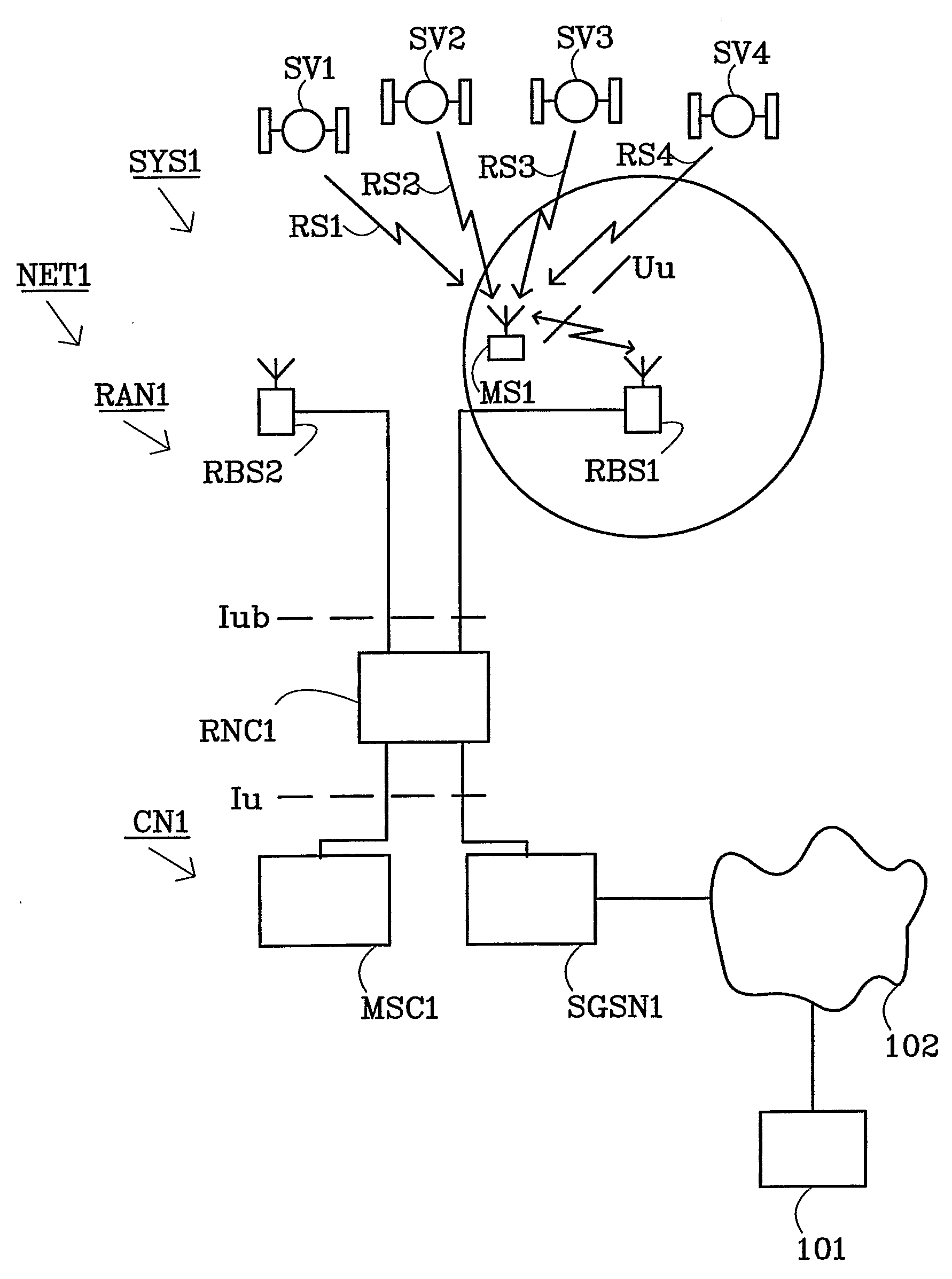
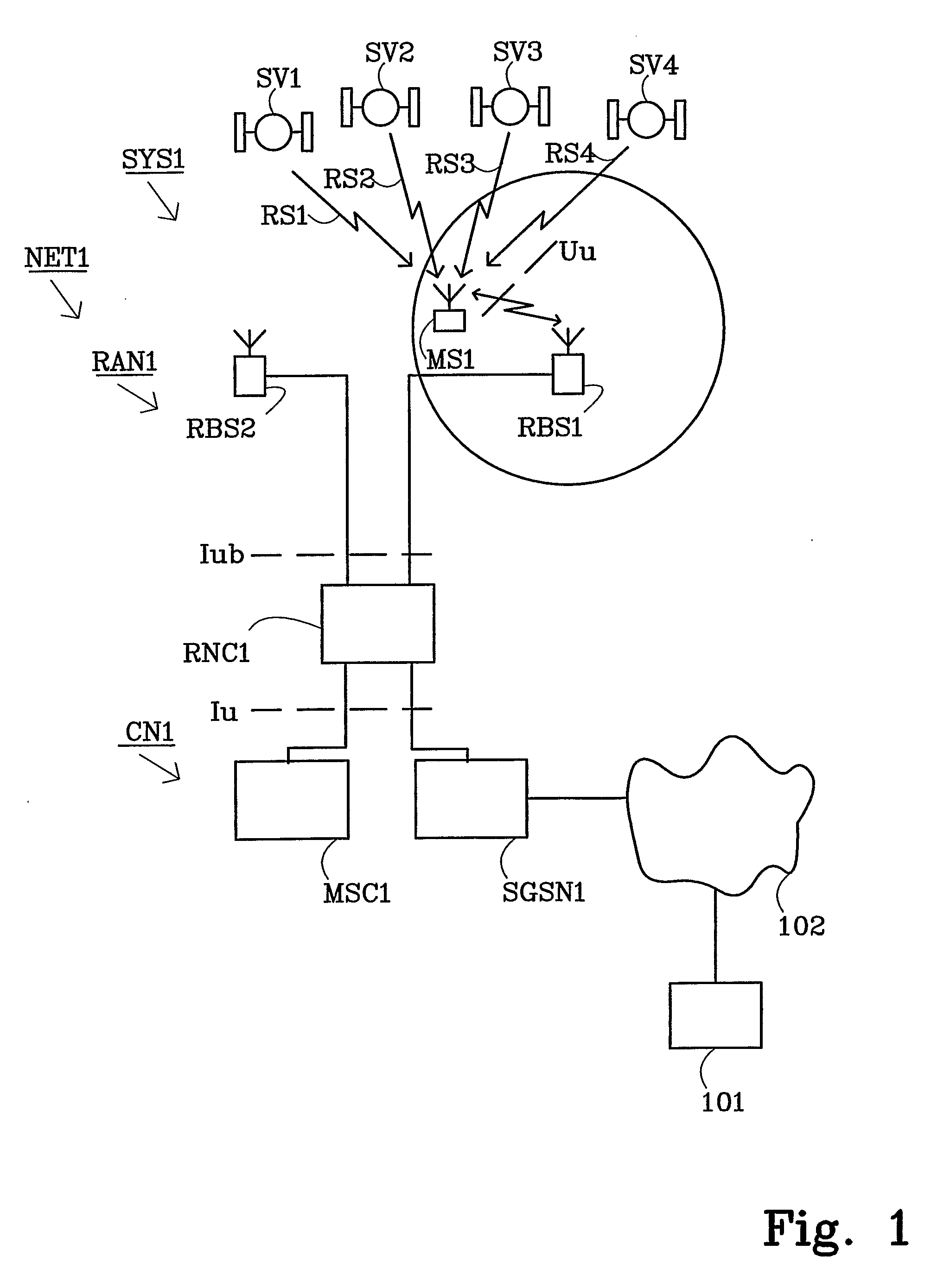
[0024]FIG. 1 illustrates a non-limiting example scenario in which the present invention may be applied. In this example scenario a basic wireless communication system SYS1 together with the Global Positioning System (GPS) is used to provide Mobile Station assisted AGPS. The example wireless communication system SYS1 illustrated in FIG. 1 is a Universal Mobile Telecommunication System (UMTS). The communication system SYS1 includes a network part NET1 and User Equipment (UE), alternatively referred to as mobile stations (MS). The network part NET1 comprises a core network CN1 and a UMTS Terrestrial Radio Access Network (UTRAN) RAN1. The core network CN1 includes a Mobile services Switching Center (MSC) node MSC1 that provides circuit-switched services and a General Packet Radio Service (GPRS) node SGSNl, sometimes referred to as a Serving GPRS Support node (SGSN), which is tailored to provide packet-switched type services.

[0025] Each of the core network nodes MSC1 and SGSN1 connects ...