Method for transmitting location information on a digital map, apparatus for implementing the method and traffic information provision/reception system

a technology of location information and digital map, applied in the field of information transmission, can solve the problems of large workload, resulting cost, and inability to accurately transmit location information, and achieve the effect of correct transmitting location

Inactive Publication Date: 2008-08-21
PANASONIC INTELLECTUAL PROPERTY CORP OF AMERICA
View PDF66 Cites 13 Cited by
  • Summary
  • Abstract
  • Description
  • Claims
  • Application Information

AI Technical Summary

Benefits of technology

The invention provides a method and apparatus for transmitting location information on a digital map without excessive maintenance workload. The method uses road shape data consisting of a string of coordinates representing the road shape of a road section and relative data indicating the on-road location in the road section. The receiving party performs shape matching to identify the road section on the digital map and uses the relative data to identify the on-road location in the road section. This allows for accurate transmission of location information on a digital map, as well as the travel direction of the vehicle without defining node numbers or link numbers on a road network.

Problems solved by technology

The problem is that map data contains errors inherent in the reduced-scale map.
Latitude / Longitude data obtained from a GPS receiver may contain errors of several tens of meters.
As long as on-road location representation is made using node numbers and link numbers, maintenance of digital map databases is permanently accompanied by huge workload and resulting costs.
This causes huge maintenance workload.

Method used


Image

  • Method for transmitting location information on a digital map, apparatus for implementing the method and traffic information provision/reception system
  • Method for transmitting location information on a digital map, apparatus for implementing the method and traffic information provision/reception system
  • Method for transmitting location information on a digital map, apparatus for implementing the method and traffic information provision/reception system

Examples


first embodiment

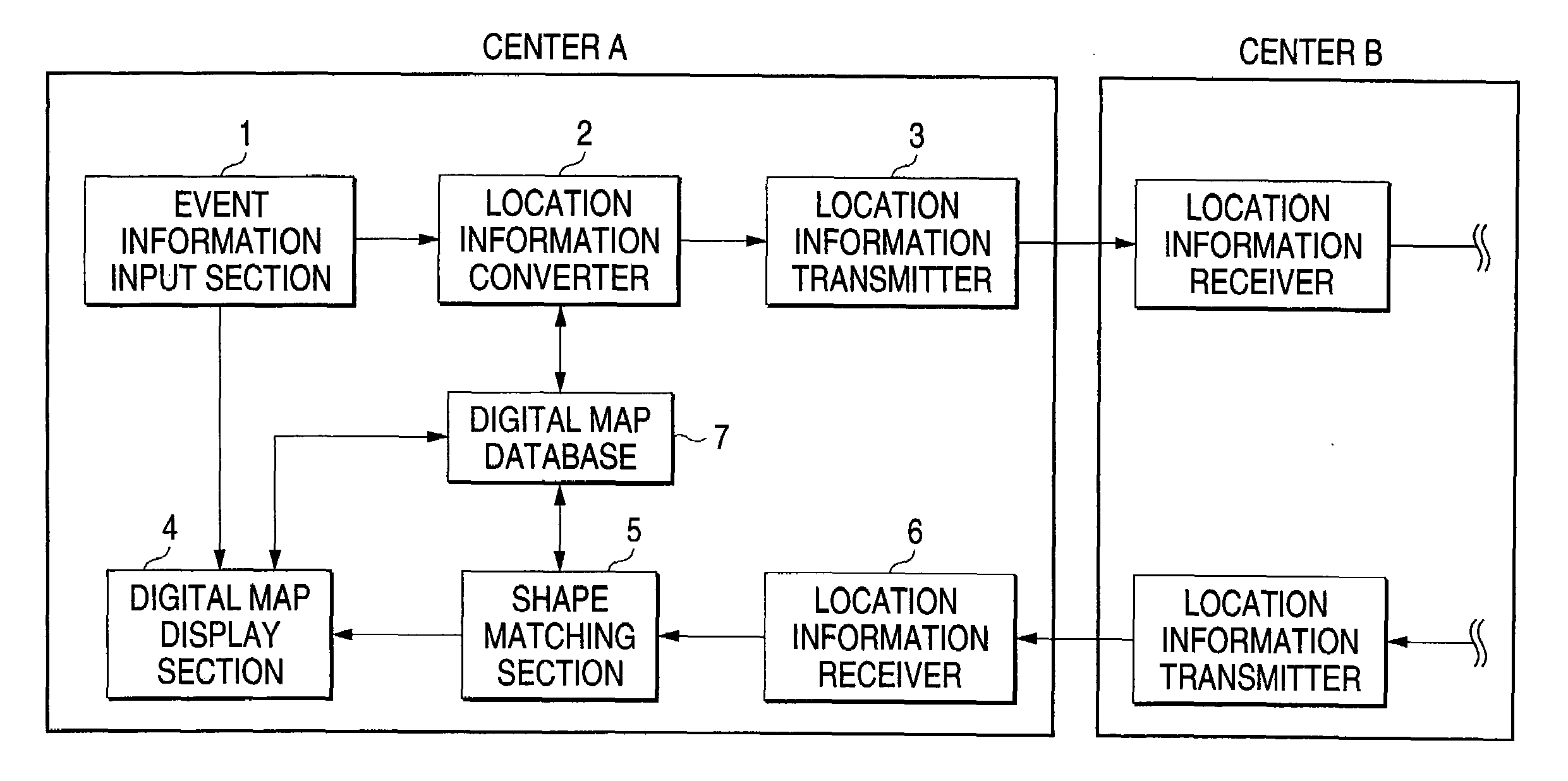
[0040]In the first embodiment, a location information transmission method according to the invention will be described taking as an example the case where traffic information is exchanged between traffic information collecting centers in FIG. 7

[0041]The traffic information collecting center A, as shown in FIG. 1, comprises an event information input section 1 for inputting event information such as traffic accidents and traffic jams, a location information converter 2 for generating location information representing the event location, a location information transmitter 3 for transmitting the generated location information, a location information receiver 6 for receiving the location information, a shape matching section 5 for performing shape matching and identifying the event location from the location information, a digital map display section 4 for displaying the event location on a map, and a digital map database 7. The traffic information collecting center B has the same confi...

second embodiment

[0058]In the second embodiment, transmission of location information between the infrastructure of the traffic information provision system (information provider) and the car-mounted navigation apparatus will be described.

[0059]Here, infrastructure refers to such social infrastructures as broadcasting stations, traffic signs, traffic signal lights or traffic monitoring cameras and soon. The social infrastructures may involve centers to control the forementioned stations, signs or other elements that are parts of the infrastructure.

[0060]FIG. 5 shows an infrastructure 51 that provides information and car-mounted navigation apparatus 61 that receives information.

[0061]The infrastructure 51 comprises an event information input section 52 for inputting event information, a location information converter 53 for generating location information representing the event location, a location information transmitter 54 for transmitting the generated location information, a digital map display s...


PUM


Abstract

Location information transmission apparatus for exchanging information about the on-road location on a digital map, characterized in that apparatus at an information provider comprises a location information converter for converting transmit on-road location information to road shape data including the on-road location consisting of a string of coordinates representing the road shape of a road section having a length that depends on the situation and relative data indicating the on-road location in the road section, and that apparatus at a party receiving the on-road location information comprises a shape matching section for performing shape matching by using the road shape data, identifying the road section on a digital map and identifying the on-road location in the road section by using the relative data. This makes it possible to correctly exchange information about the location on a digital map without defining node numbers or link numbers on a road network.

Description

[0001]This application is a continuation of U.S. patent application Ser. No. 10 / 075,208 filed Feb. 14, 2002, which is incorporated herein by reference in its entirety.BACKGROUND OF THE INVENTION[0002]1. Field of the Invention[0003]The present invention relates to an information transmission method for transmitting location information such as traffic jams and accidents for example in a traffic information provision system and apparatus for exchanging location information using the method, and in particular to such a method and apparatus that can correctly report a location on a digital map.[0004]2. Description of the Related Art[0005]In recent years, the number of vehicles that have car-mounted navigation apparatus has been increasing rapidly. The car-mounted navigation system has a digital map database and is capable of displaying the map around the vehicle on a screen based on the latitude / longitude data received by a GPS receiver as well as displaying the travel locus and the res...

Claims


Application Information

Patent Timeline
Patent Type & Authority Applications(United States)
IPC IPC(8): G01C21/30G01C21/32G08G1/09G08G1/0967G09B29/10
CPCG01C21/30G08G1/096716G09B29/106G08G1/096775G08G1/09675
Inventor ADACHI, SHINYAMIYAMA, SATOKO
Owner PANASONIC INTELLECTUAL PROPERTY CORP OF AMERICA
Why Eureka
Try Eureka