
System and Method For Monitoring and Surveying Movements of the Terrain, Large Infrastructures and Civil Building Works In General, Based Upon the Signals Transmitted by the Gps Navigation Satellite System

a technology of gps navigation satellite and system of measurement system, applied in the field of measurement system, can solve the problems of limiting the diffusion and use of measurement system based on the signals transmitted by the gps system, and the initial development of relativly expensive receivers

Inactive Publication Date: 2008-08-28
SEPA SISTEMI ELETTRONICI PER AUTOMAZIONE
View PDF2 Cites 11 Cited by
  • Summary
  • Abstract
  • Description
  • Claims
  • Application Information

AI Technical Summary

Benefits of technology

[0021]The solution according to the invention is able to ensure an extensive diffusion of measurement systems, comparable to the current diffusion of cellphones and of satellite navigators, thanks to the following advantageous effects:[0022]low cost, for enabling diffusion of fixed monitoring networks;[0023]high speed in the measurement operations;[0024]real-time processing of the data at the same rate as that of the measurement operations; and[0025]real-time communications for enabling storing and sharing of the data in the various measurement stations.
[0024]real-time processing of the data at the same rate as that of the measurement operations; and
[0025]real-time communications for enabling storing and sharing of the data in the various measurement stations.

Problems solved by technology

The systems for monitoring the territory and large infrastructures have exploited the techniques developed for geodetic applications, with the result that relatively costly receivers, originally developed for scientific applications, are at the moment ordinarily used for activities of civil engineering and monitoring of the territory and of infrastructures.
The consequence is that measurement systems based upon the signals transmitted by the GPS system have a limit of diffusion and use due to the high cost of the equipment employed.

Method used


Image

  • System and Method For Monitoring and Surveying Movements of the Terrain, Large Infrastructures and Civil Building Works In General, Based Upon the Signals Transmitted by the Gps Navigation Satellite System
  • System and Method For Monitoring and Surveying Movements of the Terrain, Large Infrastructures and Civil Building Works In General, Based Upon the Signals Transmitted by the Gps Navigation Satellite System
  • System and Method For Monitoring and Surveying Movements of the Terrain, Large Infrastructures and Civil Building Works In General, Based Upon the Signals Transmitted by the Gps Navigation Satellite System

Examples


Embodiment Construction

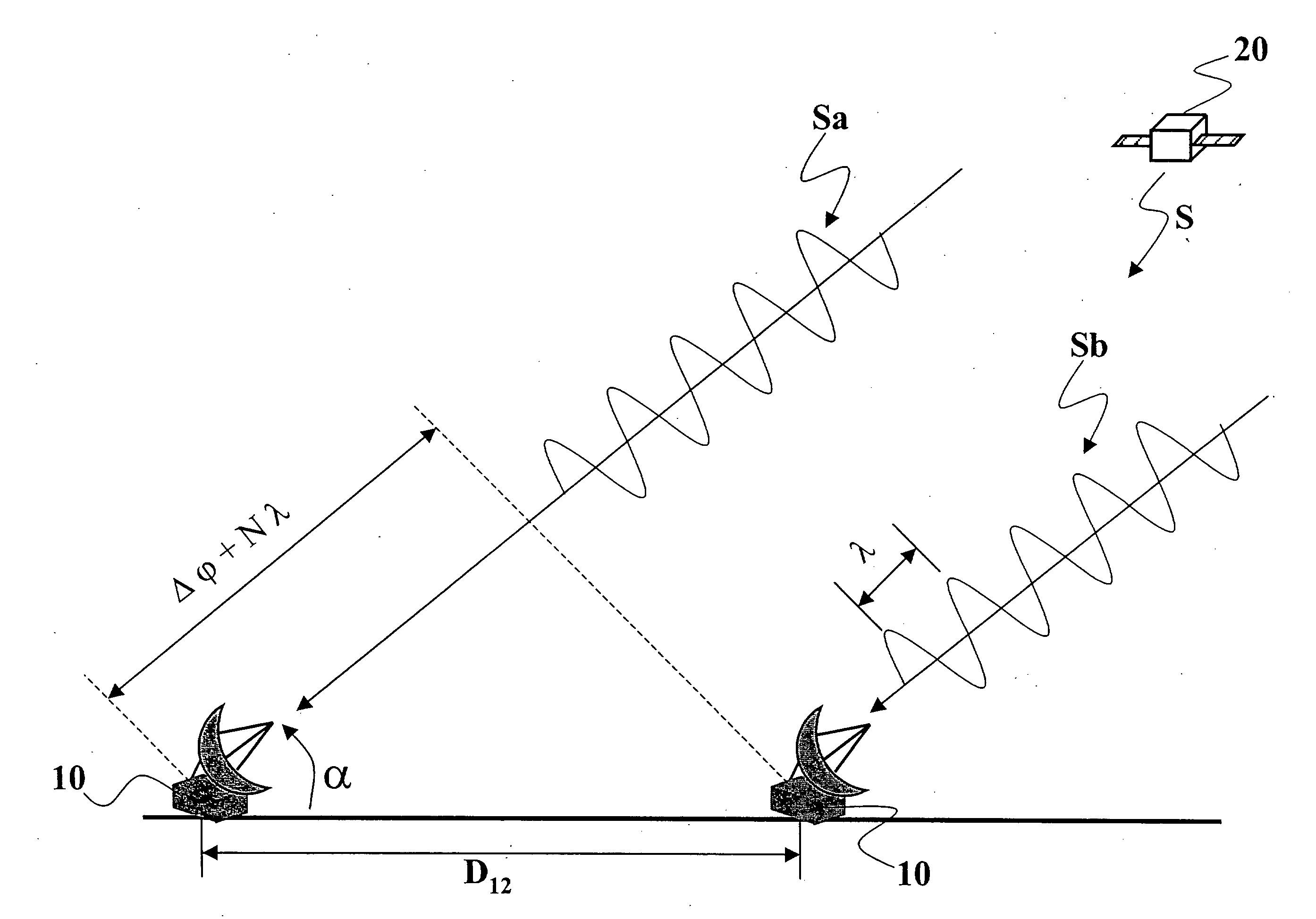
[0031]The principle underlying interferometric surveying, which is the fundamental technique of the geodetic applications that exploit measurements made by means of satellite signals, is illustrated in FIG. 1.

[0032]With reference to FIG. 1, two antennas 10 set in different positions receive a signal S transmitted by a satellite 20 in view. Let the distance between the two antennas 10 be designated by D12; this distance D12 is commonly indicated as “baseline” between the two antennas and can be calculated geometrically using the following formula:

D12=Δϕ+N·λcosα

[0033]where λ is the wavelength, Δφ is the precision of the measurements, and α is the angle of elevation of the satellite 20.

[0034]The measurement obtained from the satellite signals gives the relative distance between the two antennas 10, estimating the length of the baseline D12. Since the two distances between the antennas 10 and the satellite 20 are generally much larger than the length of the baseline D12, it may be assum...


PUM


Abstract

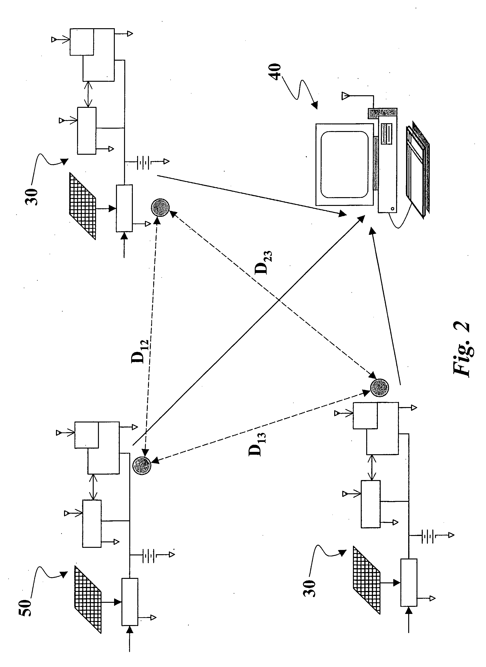
A measurement system for applications of monitoring and surveying based upon the signals transmitted by a GPS system includes a plurality of measurement stations equipped with at least one GPS receiver, one or more base stations for reception and processing of the measurements made by the plurality of measurement stations, and a network of communication between the stations. The GPS receiver is a receiver that works on a single carrier. The measurement stations are split into triangular sub-networks in which each vertex of a triangle contains a station. The base station is configured for calculating lengths of the baselines that join the measurement stations by means of the double differences, and the base station is configured for executing calculation of the solution in real time.

Description

FIELD OF THE INVENTION[0001]The present invention relates in general to measurement systems based upon signals transmitted by the navigation satellite system GPS (Global Positioning System), in particular for applications of monitoring and surveying of the displacements and deformations of the territory (landslides, landslips, natural movements of the terrain, etc.) and of buildings, dams, bridges, roads, large infrastructures, and civil building works in general.SUMMARY OF THE INVENTION[0002]The systems for monitoring the territory and large infrastructures have exploited the techniques developed for geodetic applications, with the result that relatively costly receivers, originally developed for scientific applications, are at the moment ordinarily used for activities of civil engineering and monitoring of the territory and of infrastructures.[0003]The consequence is that measurement systems based upon the signals transmitted by the GPS system have a limit of diffusion and use due...

Claims


Application Information

Patent Timeline
Patent Type & Authority Applications(United States)
IPC IPC(8): G01S5/14G01S19/43
CPCG01S19/43G01S5/0009
Inventor CAPORALI, ALESSANDRO
Owner SEPA SISTEMI ELETTRONICI PER AUTOMAZIONE
Learn More