Adding custom content to mapping applications

a mapping application and custom content technology, applied in the field of mapping application custom content, can solve the problems of limiting the amount and type of information typically provided by digital map publishers, time-consuming and costly, and limiting the ability of digital map publishers to provide such information, so as to increase the level of detail available to consumers and increase storage or bandwidth

Active Publication Date: 2008-10-02
MICROSOFT TECH LICENSING LLC
View PDF15 Cites 171 Cited by
  • Summary
  • Abstract
  • Description
  • Claims
  • Application Information

AI Technical Summary

Benefits of technology

[0004]Digital maps, especially those accessible over a network, can provide a canvas upon which a vast quantity of data can be presented. While such data would have been traditionally added to the map by the map publisher, it can be more efficient to provide mechanisms by which others can add specific details to the map. Consequently, the level of detail available to consumers of these digital maps can significantly increase without any attendant increase in the storage or bandwidth needed by the map publisher.
[0007]In another embodiment, a Uniform Resource Locator (URL) can be used to convey appropriate information necessary to identify map detail tiles corresponding to displayed map tiles. To enable programmatically unskilled individuals the ability to add details to a digital map, the URL with the relevant information can be constructed for a user based on choices made by the user via common user interface elements. For example, text-entry fields and sliders can enable a user to specify how the tiles of map details will be displayed. The user's settings can then be incorporated into an automatically constructed URL.

Problems solved by technology

However, while greater amounts of information can be efficiently consumed by the user of a digital map, and increase the user's perceived value of the digital map, the collection, maintenance and storage of such information can limit the amount and type of information typically provided by digital map publishers.
Map information that frequently changes can require continuous collection and updating efforts on the part of the digital map publisher, which can be both time consuming and costly.
Even if map information does not frequently change, the sheer quantity of information can limit the ability of the digital map publisher to provide such information.
However, detailed satellite imagery can require hundreds of gigabytes of storage space and, even more costly, it can require large amounts of network throughput if the digital map is to be provided to users through a network connection.
The storage capacity of such computer-readable media limited the amount of detail that publishers could include with digital maps.
Such network-accessed digital maps still suffer from storage constraints, though the quantity of storage available can be orders of magnitude larger.
Furthermore, the throughput of the network connections of digital map publishers can likewise limit the amount of detail that digital map publishers can provide to large numbers of simultaneous users.

Method used


Image

  • Adding custom content to mapping applications
  • Adding custom content to mapping applications
  • Adding custom content to mapping applications

Examples


Embodiment Construction

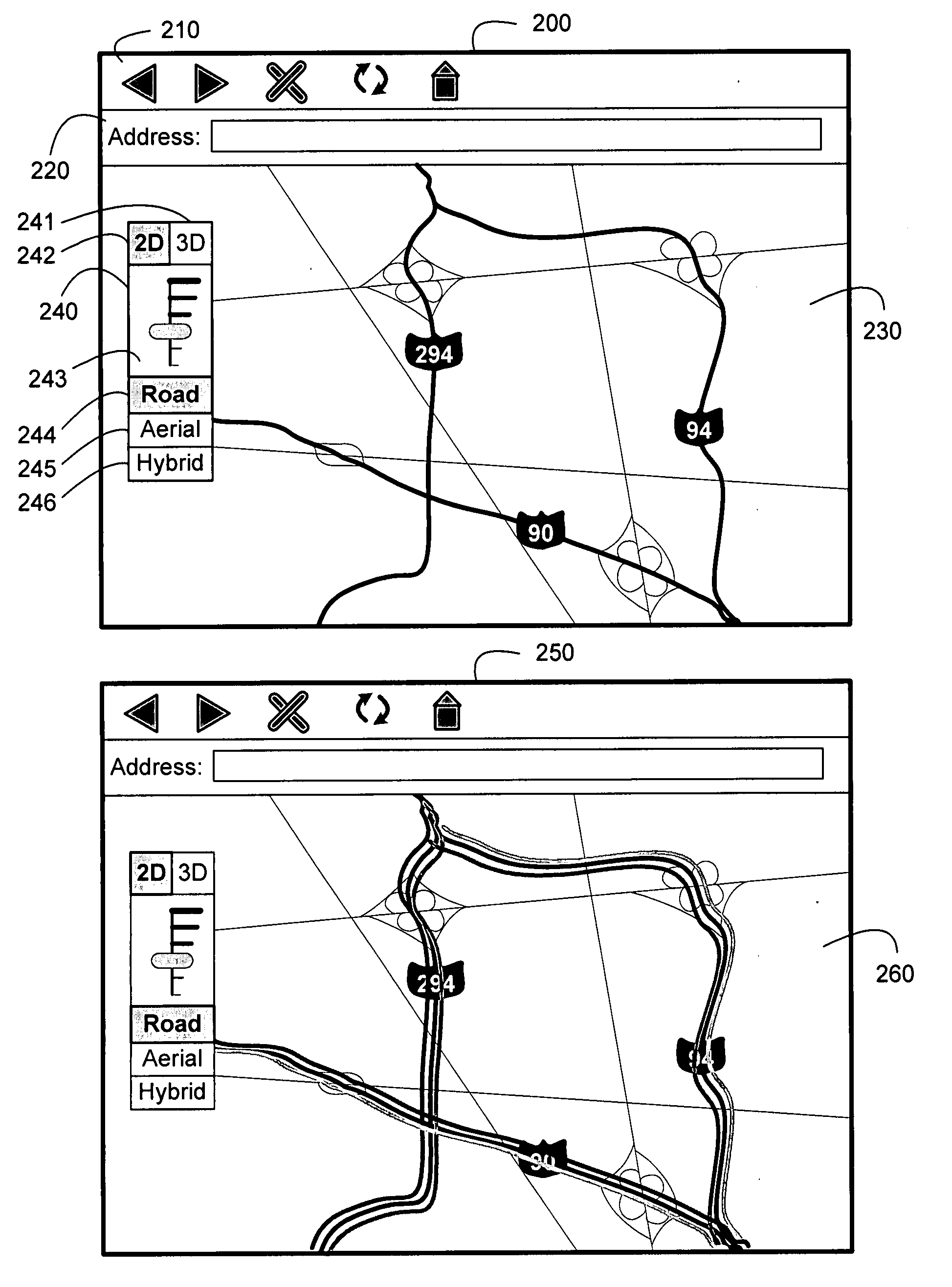
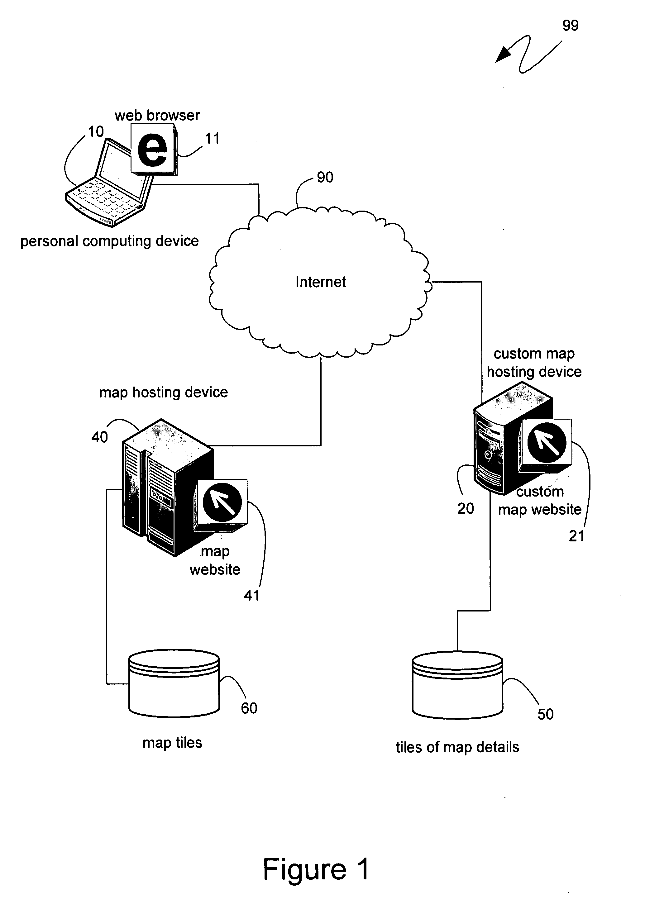
[0019]The following description relates to the independent provision of details on digital maps provided by a digital map publisher. An application, such as a specific digital map reader, or a more general network or image browser, can be used to display sections, or “tiles,” of a digital map. Further details can be provided by overlaying additional tiles with those details over the digital map tiles. Such further details can be generated, maintained, stored and provided independently of the map tiles. Interface mechanisms can facilitate the overlaying of independently provided details by selecting appropriate tiles that comprise the independently provided details and that correspond to the map tiles being shown. Such interface mechanisms can reference declarative specifications of each detail layer to identify the appropriate tiles and to instruct the application to display such map and detail tiles appropriately. Alternatively, greater ease of use can be provided by soliciting spe...


PUM


Abstract

Digital maps can be composed of a series of image tiles that are selected based on the context of the map to be presented. Independently hosted tiles can comprise additional details that can be added to the map. A manifest can be created that describes the layers of map details composed of such independently hosted tiles. Externally referable mechanisms can, based on the manifest and map context, select tiles, from among the independently hosted tiles, that correspond to map tiles being displayed to a user. Subsequently, the mechanisms can instruct a browser, as specified in the manifest, to combine the map tiles and the independently hosted tiles to generate a more detailed map. Alternatively, customized mechanisms can generate map detail tiles in real-time, based on an exported map context. Also, controls instantiated by the browser can render three-dimensional images based on the combined map tiles.

Description

BACKGROUND[0001]Paper-based map designers have always faced a Hobson's choice: they could choose to include greater amounts of detail and create a map that was either too large or too cluttered, or they could choose to remove details and create a map that did not contain the relevant information needed by its users. Digital maps accessed via a computing device do not present such a choice. Instead, because the level of detail displayed can be adjusted by the user, such as through a zoom function, digital map designers can include as much detail as can be conveniently and efficiently created, stored and accessed. User control of the amount of detail displayed, and the geographic area displayed, enables each user of a digital map to customize the displayed map for their own purposes.[0002]However, while greater amounts of information can be efficiently consumed by the user of a digital map, and increase the user's perceived value of the digital map, the collection, maintenance and sto...

Claims


Application Information

Patent Timeline
Patent Type & Authority Applications(United States)
IPC IPC(8): G09G5/00
CPCG09B29/007G06F16/29G06T15/04G06T15/20G06T17/05G06T19/20G06T2200/04G06T2207/30184G06T2210/04
Inventor KINNAN, KEITH ROBERTTHOTA, CHANDRASEKHARBHATIA, JAYAELSON, JEREMY ERICHOWELL, JONATHAN R.FISHER, DANYELDOUCEUR, JOHN R.LAWLER, DUNCAN MURRAY
Owner MICROSOFT TECH LICENSING LLC
Why Eureka
Try Eureka