Guidance, Navigation, and Control System for a Vehicle

a technology of navigation and control system, applied in the direction of programme control, distance measurement, instruments, etc., can solve the problems of inability to reliably operate a system that rely entirely on the topology of the classification tunnel to guide, the inability of automatic solution to provide good positioning information from this (external) system, and the high cost of installing the track/strip/light-rope infrastructur

Active Publication Date: 2009-02-12
MACDONALD DETTWILER & ASSOC INC
View PDF6 Cites 103 Cited by
  • Summary
  • Abstract
  • Description
  • Claims
  • Application Information

AI Technical Summary

Problems solved by technology

One of the key challenges of autotramming is that the global positioning system (GPS) is not available underground and thus the automation solution cannot rely on having good positioning information provided from this (external) system.
Although these solutions were partially successful, installing the track / strip / light-rope infrastructure was very expensive and it was highly onerous to change the route as the infrastructure had to be altered.
In mobile robotics research, systems similar to this that rely entirely on classifying tunnel topology to navigate have been shown to not operate robustly due to inevitable misclassifications that occur in practice.
Other disadvantages of the disclosed system include: it does not discuss how the vehicle speed will be controlled, it does not explain how to account for vehicle dynamics (e.g., vehicle inertia, hydraulic steering, and engine dynamics) when controlling the steering and speed, and it does not claim a teaching method for creating the graph that represents the layout of the passageway environment.
As discussed above, systems similar to this that rely entirely on classifying tunnel topology to navigate have been shown to not operate robustly due to inevitable misclassifications of topology that occur in practice.

Method used


Image

  • Guidance, Navigation, and Control System for a Vehicle
  • Guidance, Navigation, and Control System for a Vehicle
  • Guidance, Navigation, and Control System for a Vehicle

Examples


Embodiment Construction

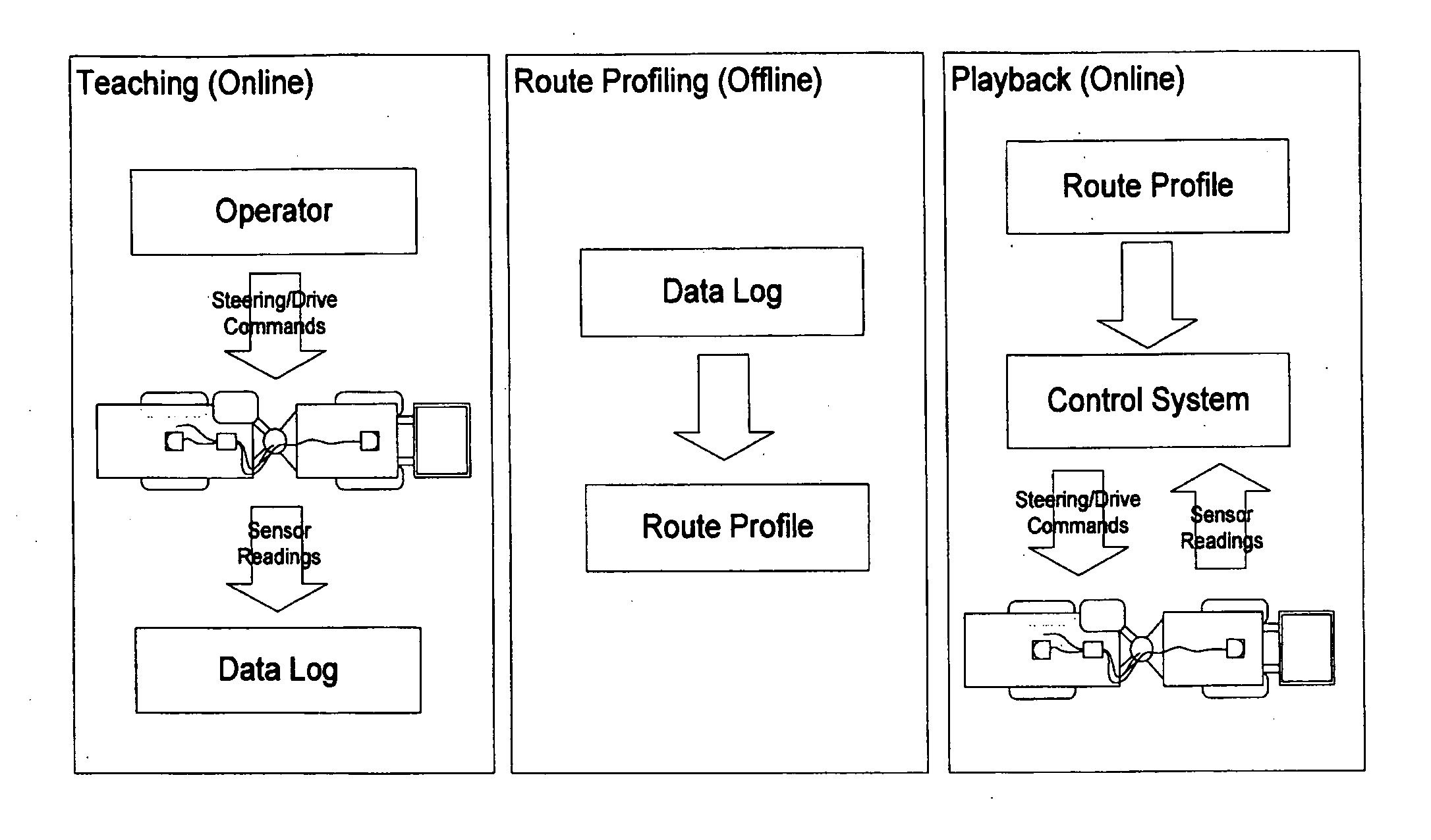
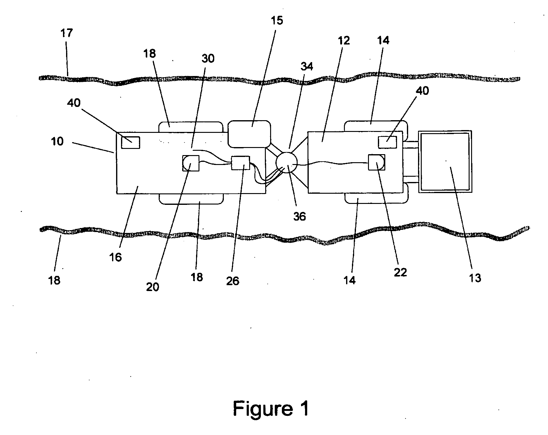
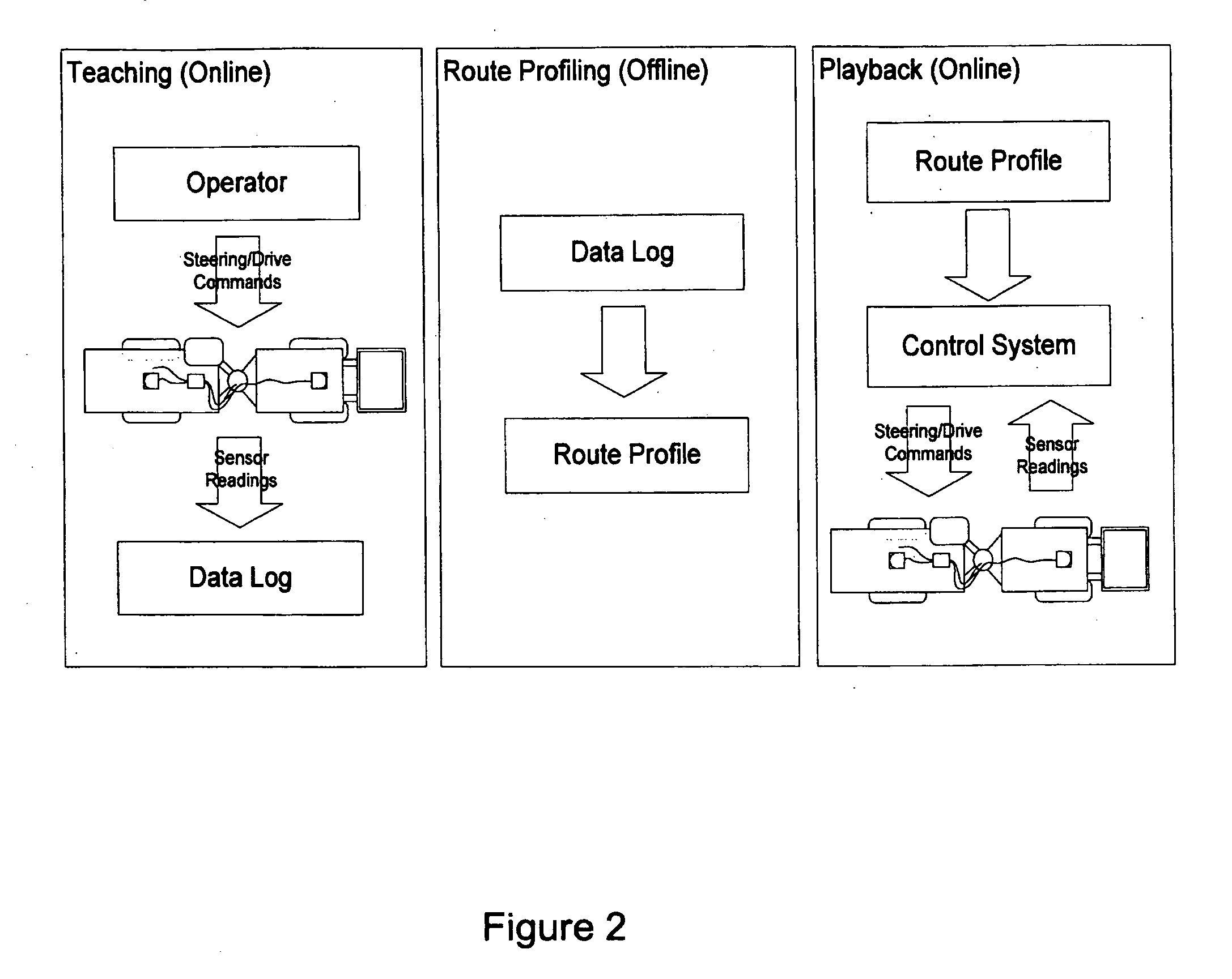
[0060]As used herein, the phrase “passageway environment” means any space where vehicles might travel that contains walls, barriers, or obstacles such that said vehicles must travel amongst these objects. Examples of passageway environments include streets among buildings, building hallways, office spaces, underground mines, tunnels, caves, etc. Herein, it is assumed that passageway environments can be represented by maps.

[0061]As used herein, a “map” refers to a representation of a region of a passageway environment.

[0062]As used herein, the phrase “metric map” means a map in which the notion of distances between points on the map is defined.

[0063]As used herein, the phrase “topological map” means a map in which the notion of distances between points on the map is not defined.

[0064]As used herein, a “consistent map” refers to a map in which:[0065]a) no two (or more) points on the map represent the same point in the physical environment;[0066]b) no one point in the map represents tw...


PUM


Abstract

The present invention provides a guidance, navigation, and control method and system for an underground mining vehicle that allow said vehicle to be taught a route by a human operator and then have it automatically drive the route with no human intervention. The method works in three steps: teaching, route profiling, and playback. In the teaching step the vehicle is manually driven by a operator (or using tele-operation whereby the operator views a screen displaying live views from vehicle-mounted cameras and using remote controls) along a route which can consist of an arbitrary sequence of maneuvers including tramming forwards, switching directions, tramming backwards, turning, or pausing movement. During this phase raw data from vehicle-mounted sensors including odometric sensors and rangefinders are logged to a file throughout teaching for later processing. During the (offline) route profiling step, the raw data in the log file are processed into a route profile including a vehicle path, a sequence of local metric submaps located along the path, and a profile of desired speed as a function of distance along the path. During the playback step, the vehicle automatically repeats the route that was taught during the teaching phase, as represented by the route profile. This is accomplished by first determining where the vehicle is on the route using a localization method which uses the odometric and laser rangefinder sensors and the local metric maps to determine the vehicle location. A steering control method adjusts the vehicle's steering to ensure it tracks the intended path. A drive control method adjusts the vehicle's speed accordingly and safety method ensures the vehicle stops in the event that an obstruction is on the vehicle's intended path.

Description

CROSS REFERENCE TO RELATED U.S PATENT APPLICATION[0001]This patent application relates to U.S. provisional patent application Ser. No. 60 / 702,285 filed on Jul. 26, 2005 entitled GUIDANCE, NAVIGATION, AND CONTROL SYSTEM FOR UNDERGROUND MINING VEHICLES, filed in English, which is incorporated herein in its entirety by reference.FIELD OF THE INVENTION[0002]The present invention is related to guidance, navigation, and control methods for a vehicle that allows the vehicle to be taught a route by a human operator (either manually or through tele-operation) and then have it automatically drive the route with no human intervention.BACKGROUND OF THE INVENTION[0003]Underground mining is a complex operation whose goal is to extract as much resource as possible at the lowest possible cost. For example, in many mines, a network of rooms and pillars is carved out to maximize the amount of extracted ore while maintaining adequate roof support in order to avoid cave-ins.[0004]Conventional mining te...

Claims


Application Information

Patent Timeline
Patent Type & Authority Applications(United States)
IPC IPC(8): B60W30/10
CPCB60W10/04G05D1/0297B60W2050/0028B60W2550/14B60W2550/402G05B2219/40555G05B2219/45004G05D2201/021G08G1/20G08G1/202G05D1/024G05D1/0261G05D1/027G05D1/0274B60W10/20B60W2552/00B60W2556/50
Inventor BARFOOT, TIMOTHY D.MARSHALL, JOSHUA A.MUKHERJI, RAJAWARD, ROBRET
Owner MACDONALD DETTWILER & ASSOC INC
Why Eureka
Try Eureka