Modular navigation system and methods

a navigation system and module technology, applied in the field of navigation systems and methods, can solve the problems of difficult for satellite navigation signals to reach positioning and navigation receivers, inability to utilize various types of complementary data from other sensors, and inability to use current solutions. to achieve the effect of avoiding interference and jamming

Inactive Publication Date: 2010-02-18
TEMPLE UNIVERSITY
View PDF24 Cites 14 Cited by
  • Summary
  • Abstract
  • Description
  • Claims
  • Application Information

AI Technical Summary

Problems solved by technology

A disadvantage of the satellite based navigation is that the signal can be weak so it is susceptible to interference and jamming.
Also, in some instances, it is difficult for satellite navigation signals to reach positioning and navigation receivers when there are tall buildings,

Method used


Image

  • Modular navigation system and methods
  • Modular navigation system and methods
  • Modular navigation system and methods

Examples


Embodiment Construction

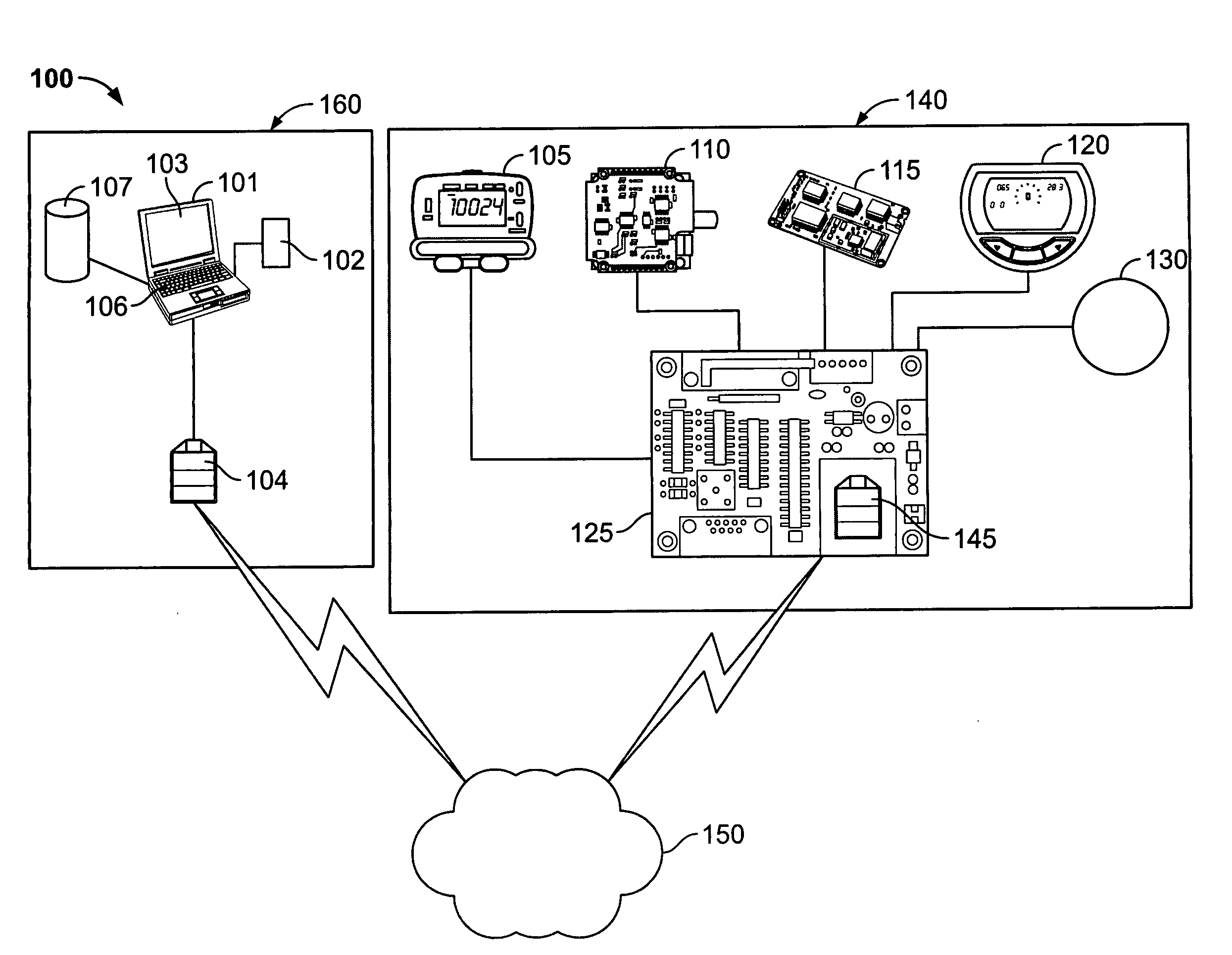
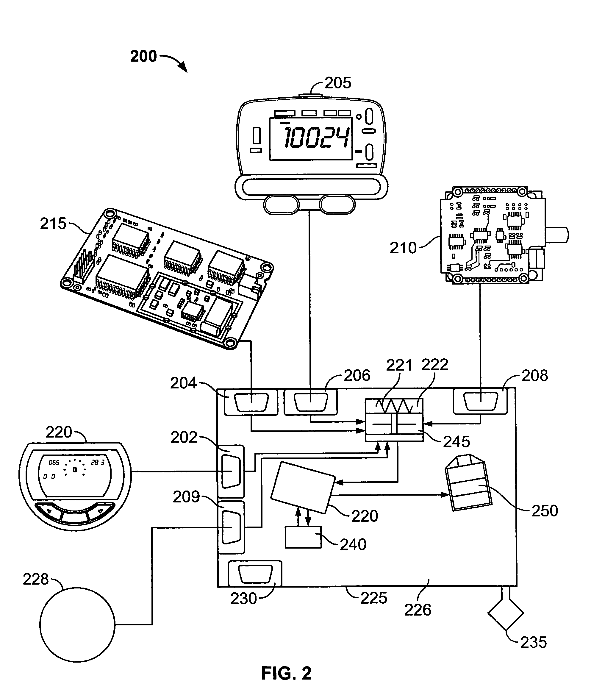
[0021]The herein described system and methods illustratively operate to generate robust and reliable output data comprising positioning and orientation data in a stressed environment. In one embodiment, the generation of such data can be accomplished in the absence of reliable satellite-based navigation and positioning signals.

[0022]In an embodiment of the invention, a navigation module comprises an integration module and a plurality of sensors. The integration module may comprise an integration member, a memory device storing instructions for determining optimally estimated position and orientation data for a subject in a stressed environment, and a computing device. The integration member may be, but is not limited to, a board or a printed circuit board (PCB). The computing device may be a microprocessor, a processor or a computer. The integration member is connected to each of the sensors. The connection between the integration member and each of the sensors may be wireless, or t...


PUM


Abstract

Systems and methods are provided to generate positioning and orientation data for subjects disposed in stressed environments. In an illustrative implementation, a navigation module comprises an integration module and various sensors to determine the position and orientation of the user. In the illustrative implementation, the navigation module may cooperate with a larger navigation platform comprising a global navigation satellite system (GNSS) receiver, inertial measurement unit (IMU), altimeter, magnetometer, pedometer, and an angular measuring device. Additionally, the illustrative integration module may comprise power and signal conditioning circuitry, a transceiver to send the position and orientation information to other cooperating components such as a monitoring device and integration software for use in processing the various sensor data.

Description

CROSS-REFERENCE TO RELATED PATENT APPLICATIONS[0001]This patent application claims the benefit of U.S. Provisional Patent Application No. 60 / 874,614, filed Dec. 13, 2006.REFERENCE TO GOVERNMENT GRANT[0002]This invention was made in part with Government support under Grant Number ECS-0554748 awarded by the National Science Foundation. The Government may have certain rights in this invention.FIELD OF THE INVENTION[0003]This invention pertains to navigation systems and methods.BACKGROUND OF THE INVENTION[0004]Positioning technologies have availed various commercial applications which are becoming commonplace. Included in such technologies are global navigation satellite system (GNSS) applications which have become integrated in various modalities ranging from mobile phones and camping gear to mobile navigation systems. GNSS is a system of satellites that sends navigation signals to a receiver. Although there may be more in the future, currently there are three GNSS systems: Global Navi...

Claims


Application Information

Patent Timeline
IPC IPC(8): G01C21/00G01C22/00G01C21/18
CPCG01C22/006G01C21/165
Inventor WON, CHANG-HEE
Owner TEMPLE UNIVERSITY
Why Eureka
Try Eureka