GPS with aiding from ad-hoc peer-to-peer bluetooth networks

a technology of bluetooth network and gps, applied in satellite radio beaconing, measurement devices, instruments, etc., can solve the problems of low time-to-first fix (ttff, longer ttff), local oscillator instability, etc., and achieve the effect of reducing the likelihood of ephemeris data becoming out of da

Inactive Publication Date: 2011-07-07
CSR TECH HLDG
View PDF22 Cites 114 Cited by
  • Summary
  • Abstract
  • Description
  • Claims
  • Application Information

AI Technical Summary

Benefits of technology

[0015]According to yet another aspect, the invention utilizes the deep hole map data such that when a device is nearing a deep hole area, the GPS enabled mobile device initiates an update of its ephemeris data to reduce the likelihood of the ephemeris data becoming out of date.

Problems solved by technology

Additional frequency variation may result from local oscillator instability.
As expected the ‘hot start’ mode results in low Time-To-First-Fix (TTFF) while the ‘warm start’ mode which has non-current ephemeris may use that ephemeris or the almanac resulting in longer TTFF due to the less accurate Doppler estimation and ephemeris downloading.
The ‘cold start’ takes still more time for the first position fix as there is no data available to aid signal acquisition and position fix.
However, this approach results in higher cost and requires additional infrastructure.
Moreover, such extended ephemeris products not only start tracking satellites and navigating more quickly, they can do it using signals much weaker than those needed to obtain satellite location data the traditional way, removing the barrier that often blocks successful navigation under tough GPS signal conditions.
However, this method leads to additional cellular over the air charges.
Nevertheless, some challenges remain.
For example, when the receiver is in a location in which satellite signal is not available such as large office buildings, subways, indoor malls, expo halls, etc., the GPS receiver's stored ephemeris data and time may become out-of-date.
Without any GPS signal, cellular signal or other supplementary external data source, the tracker cannot determine when to start looking for SV or cellular signal.
Under these circumstances the battery for the GPS receiver can quickly be run down by repeated unsuccessful attempts to update the ephemeris and time data.

Method used


Image

  • GPS with aiding from ad-hoc peer-to-peer bluetooth networks
  • GPS with aiding from ad-hoc peer-to-peer bluetooth networks
  • GPS with aiding from ad-hoc peer-to-peer bluetooth networks

Examples


Embodiment Construction

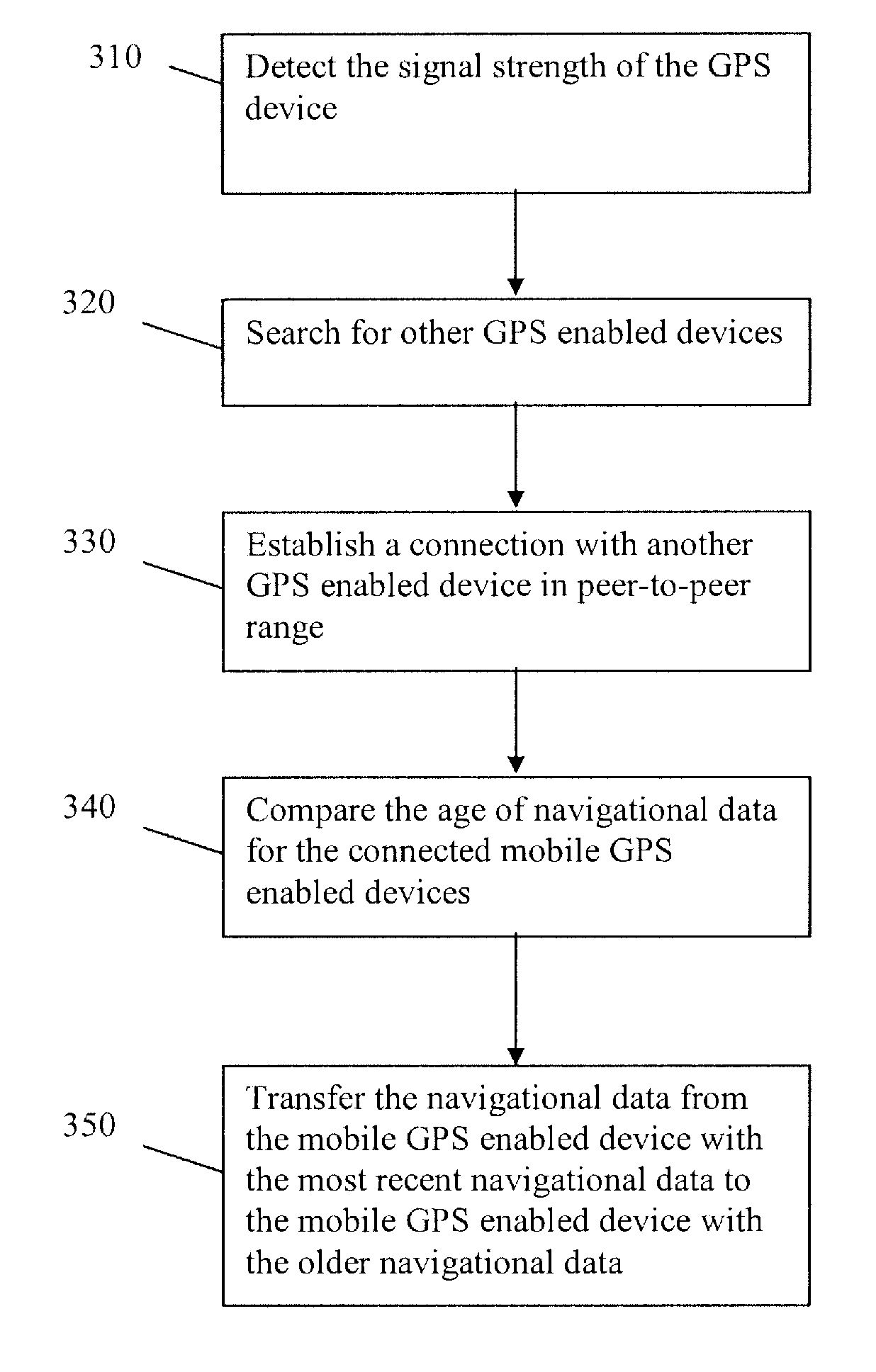
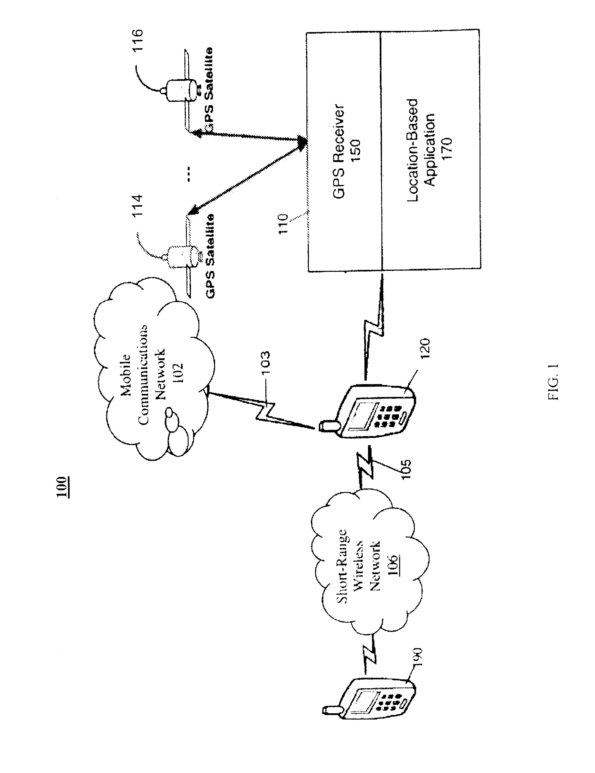
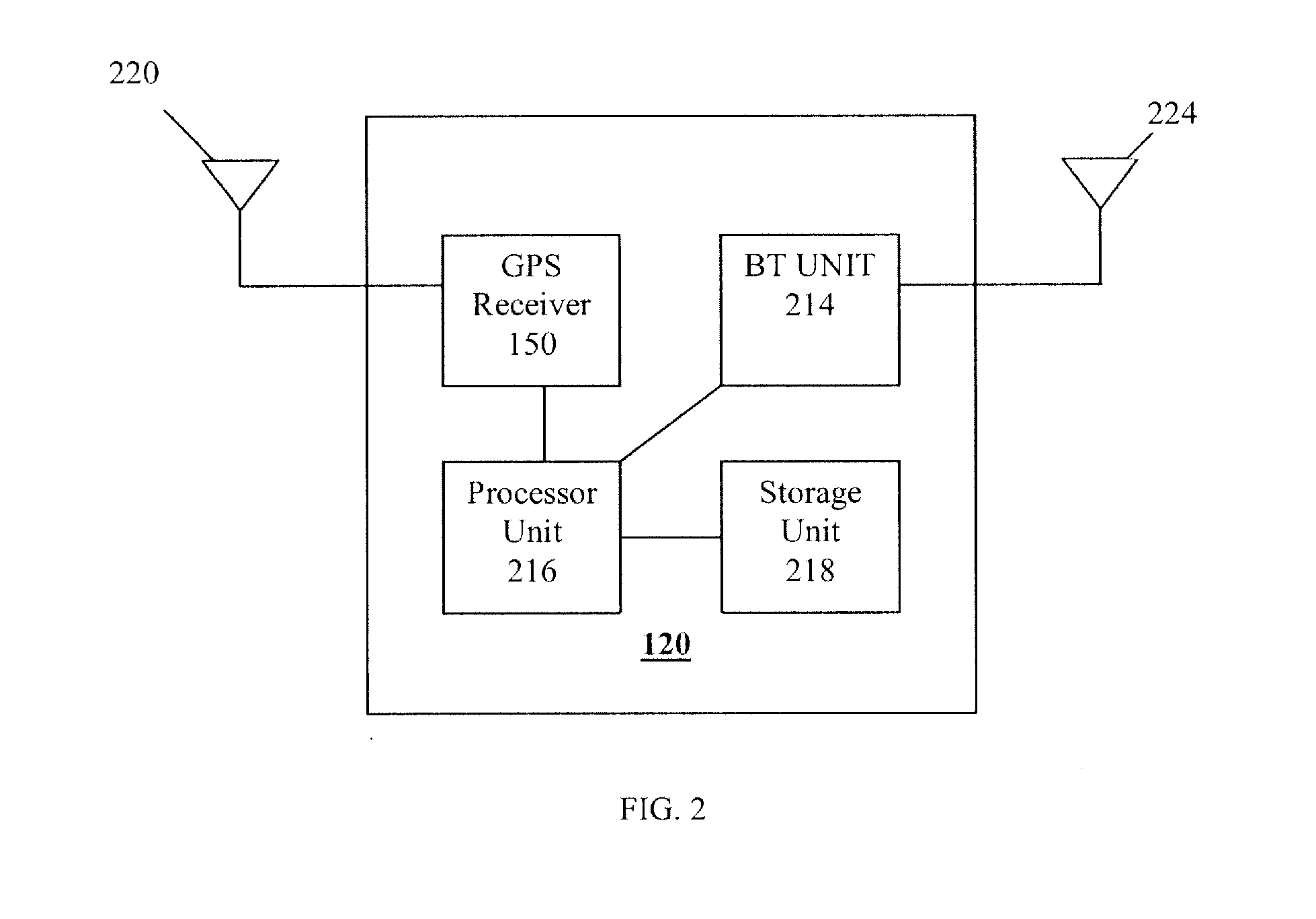
[0025]The present invention will now be described in detail with reference to the drawings, which are provided as illustrative examples of the invention so as to enable those skilled in the art to practice the invention. Notably, the figures and examples below are not meant to limit the scope of the present invention to a single embodiment, but other embodiments are possible by way of interchange of some or all of the described or illustrated elements. Moreover, where certain elements of the present invention can be partially or fully implemented using known components, only those portions of such known components that are necessary for an understanding of the present invention will be described, and detailed descriptions of other portions of such known components will be omitted so as not to obscure the invention. Embodiments described as being implemented in software should not be limited thereto, but can include embodiments implemented in hardware, or combinations of software and...


PUM


Abstract

The present invention is related to location positioning systems, and more particularly, to a method and apparatus for providing an update of ephemeris information. According to one aspect, GPS enabled devices in the signal unavailable area monitors the state of its ephemeris data and time information. When the ephemeris data and time information become out of date, the GPS enable device uses an ad hoc Bluetooth network to retrieve ephemeris data and time information from another GPS enabled device with more current data. According to further aspects, a map of a deep hole region in which GPS and other cellular signals are not available, is generated to enable power reduction and cost saving measures.

Description

FIELD OF THE INVENTION[0001]The present invention is related to location positioning systems, and more particularly, to a method for providing updated navigational data via a short range wireless network.BACKGROUND OF THE INVENTION[0002]With the development of radio and space technologies, several satellites based navigation systems (i.e. satellite positioning system or “SPS”) have already been built and more will be in use in the near future. SPS receivers, such as, for example, receivers using the Global Positioning System (“GPS”), also known as NAVSTAR, have become commonplace. Other examples of SPS systems include but are not limited to the United States (“U.S.”) Navy Navigation Satellite System (“NNSS”) (also known as TRANSIT), LORAN, Shoran, Decca, TACAN, NAVSTAR, the Russian counterpart to NAVSTAR known as the Global Navigation Satellite System (“GLONASS”) and any future Western European SPS such as the proposed “Galileo” program. As an example, the U.S. NAVSTAR GPS system is...

Claims


Application Information

Patent Timeline
Patent Type & Authority Applications(United States)
IPC IPC(8): G01S19/05
CPCG01S5/0072G01S19/05G01S19/27G01S19/06G01S19/258G01S19/34
Inventor SEYMOUR, LESLIE
Owner CSR TECH HLDG
Why Eureka
Try Eureka