Receiver coil assembly for airborne geophysical surveying with noise mitigation

a geophysical surveying and receiver coil technology, applied in the field of airborne geological mapping and receiver systems, can solve the problems of affecting the desired signal, requiring larger receiver coils, and weak signals used in natural source systems

Active Publication Date: 2011-07-28
GEOTECH
View PDF15 Cites 21 Cited by
  • Summary
  • Abstract
  • Description
  • Claims
  • Application Information

AI Technical Summary

Benefits of technology

According to another example embodiment is a receiver coil assembly for towing by an aircraft for performing geophysical surveys, comprising a semi-rigid outer shell having a nominally vertical extent which is substantially less than an horizontal extent thereof, the outer shell housing a multiturn air core receiver coil and at least one solenoid receiver coils, each receiver coil sensing changes in a different magnetic field component and having an axis at a known angle to the axis of the other receiver coil, wherein the multiturn air core receiver coil has a nominally vertical axis and the solenoid receiver coil comprises a multiturn solenoid winding with a ferromagnetic core and has a horizontal axis.

Problems solved by technology

The signals used in natural source systems are typically weaker, requiring larger receiver coils, compared to active source systems.
The response to movement and vibration of receivers used in active and natural source surveying systems is a significant noise source, especially in a turbulent airborne environment, becoming increasingly important as the signal frequency decreases below 100 Hz.
No receiver coil is perfectly rigid, so flexing of the coil also contributes to such voltages.
These voltages are a type of noise that interferes with the desired signal.
Receivers that independently measure changes in two or three substantially orthogonal components of the magnetic field provide improved geological information, but are bulkier than single axis receivers.

Method used


Image

  • Receiver coil assembly for airborne geophysical surveying with noise mitigation
  • Receiver coil assembly for airborne geophysical surveying with noise mitigation
  • Receiver coil assembly for airborne geophysical surveying with noise mitigation

Examples


Embodiment Construction

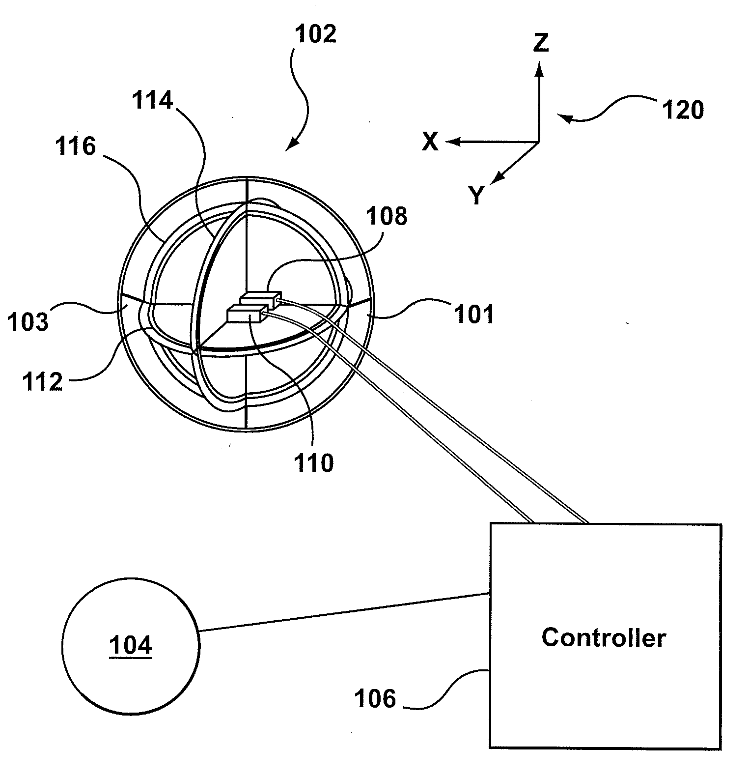
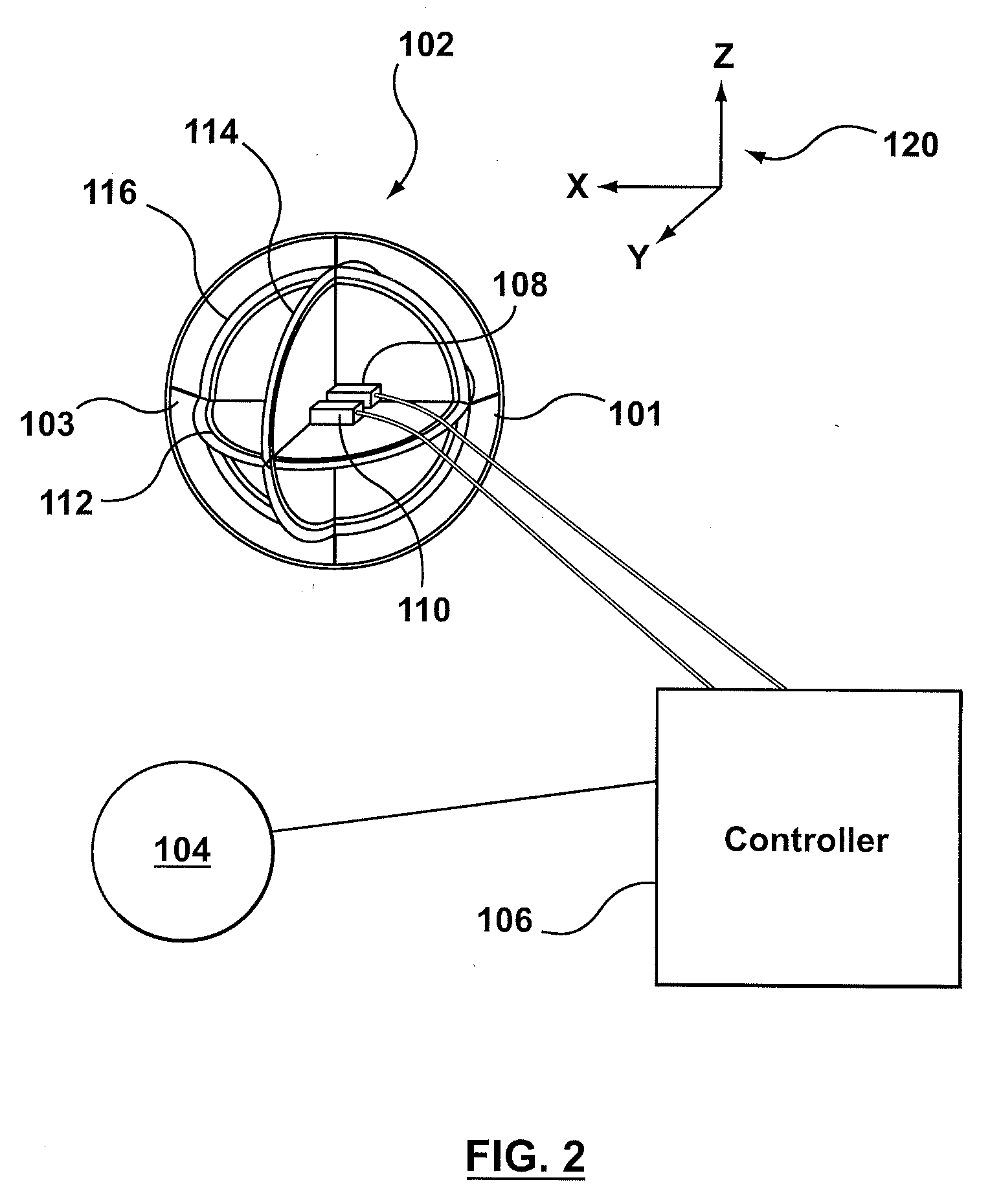
In one example embodiment, the receiver coil system includes a substantially rigid assembly carrying three coils of electrical wire having mutually orthogonal axes. These coils sense changes in three independent components of the magnetic field, which provides more information than a single axis receiver. In addition, the assembly carries an orientation sensing system, including angular accelerometers, a three axis fluxgate magnetometer and two axis tilt sensors. The rigid assembly is elastically suspended within a non-metallic enclosing outer shell which protects it from air flow and is in turn suspended directly or indirectly from a towing aircraft. The elastic suspension attenuates motion and vibration transmitted to the rigid assembly from the outer shell.

In this first example embodiment, a processing system accepts the outputs of the orientation sensing system. It uses them to calculate, and subtract from each of the receiver coil outputs, the noise which is caused by rotationa...


PUM


Abstract

An airborne geophysical surveying system comprising a receiver coil assembly for towing by an aircraft, the receiver assembly including a receiver coil for sensing changes in a magnetic field component of a magnetic field, and a receiver coil orientation sensing system for sensing orientation changes of the receiver coil. A controller receives signals representing the sensed changes in the magnetic field component from the receiver coil and the sensed orientation changes from the receiver coil orientation sensing system and corrects the sensed changes in the magnetic field component to provide a signal that is corrected for noise caused by changing orientation of the receiver coil in a static geomagnetic field.

Description

BACKGROUNDEmbodiments of the described invention relate to the field of airborne geological mapping and receiver systems used for such mapping.Active source electromagnetic surveying such as time domain electromagnetic (TDEM) surveying is a rapidly developing area of geophysical surveying. It encompasses ground based and airborne applications. TDEM geological mapping involves measuring the magnetic response of the earth to a primary magnetic field transmitted by the survey system. The relation between the transmitted field and the response is used to calculate the electrical resistivity structure of the earth, from which geological information is inferred.An example of a TDEM surveying system and method is shown in U.S. Pat. No. 7,157,914.Natural source electromagnetic surveying has traditionally been performed using ground based techniques such as the magnetotelluric (MT) technique. Recently, airborne surveying using natural source electromagnetic techniques has become practical. I...

Claims


Application Information

Patent Timeline
Patent Type & Authority Applications(United States)
IPC IPC(8): G01V3/16
CPCG01V3/17
Inventor KUZMIN, PETR VALENTINOVICHDODDS, JACK
Owner GEOTECH
Why Eureka
Try Eureka