
Use of accelerometer only data to improve GNSS performance

a technology of accelerometer and only data, applied in the direction of navigation instruments, liquid/fluent solid measurements, instruments, etc., can solve the problems of inability to align and/or accurately calibrate accelerometers, inability to allow ins type integration, and inability to accurately and accurately calibrate accelerometers. to achieve the effect of low cost, low cost and assisting image stabilization

Inactive Publication Date: 2011-07-28
CSR TECH HLDG
View PDF12 Cites 29 Cited by
  • Summary
  • Abstract
  • Description
  • Claims
  • Application Information

AI Technical Summary

Benefits of technology

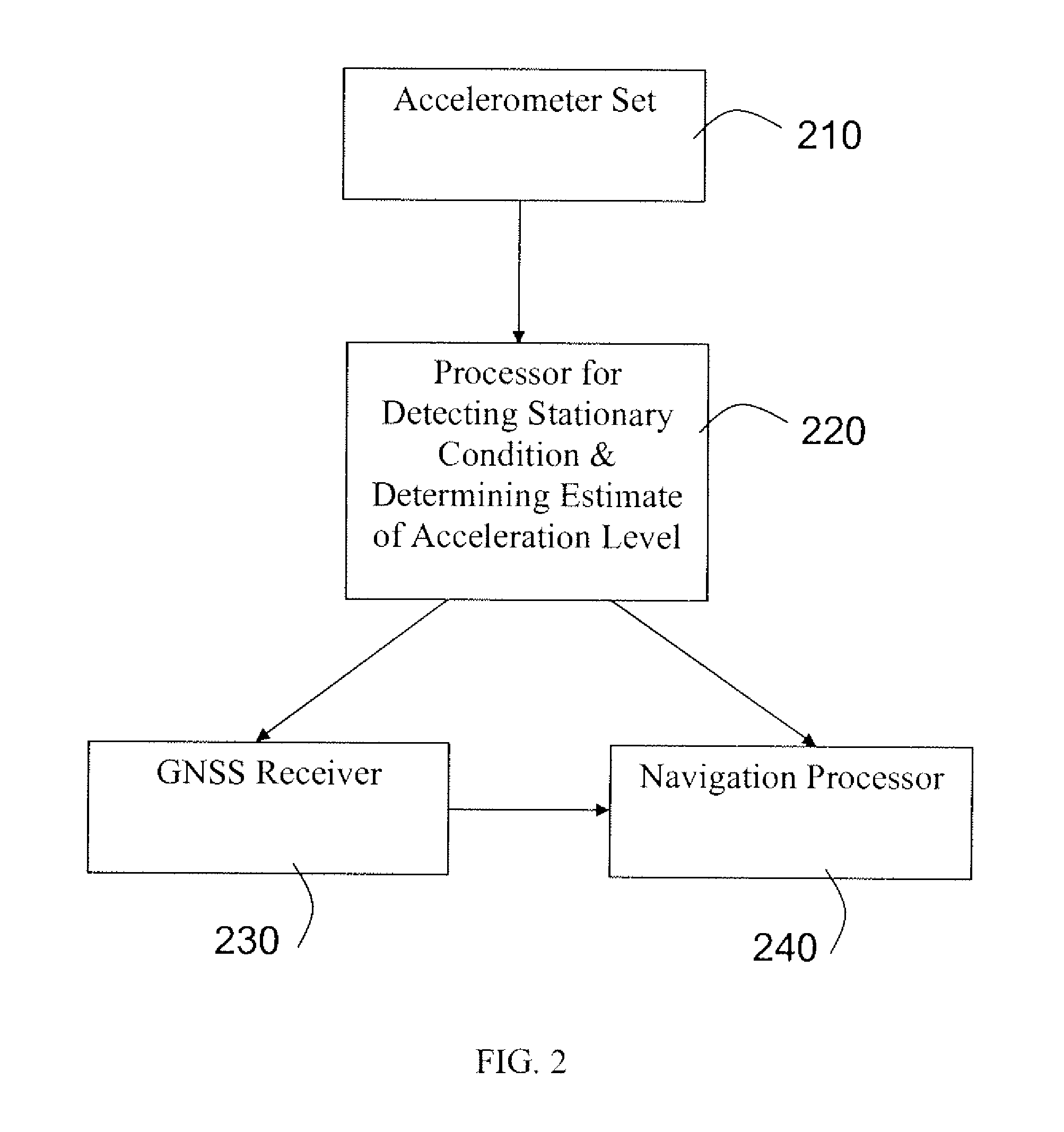
"The present invention provides methods for improving satellite navigation by assessing the dynamic state of the platform for the satellite navigation receiver and using this data to improve navigation models and satellite tracking algorithms. This assessment of the dynamic state may only be needed at a very approximate level, in which case the accelerometers need not be very accurate and need not be aligned and / or accurately calibrated. The invention uses low cost accelerometers integrated into cell phones and other platforms to assist with image stabilization and map orientation. The accelerometer data can be categorized and used to enhance satellite navigation in aspects of satellite signal acquisition, reacquisition, and tracking. The invention also includes a system for accelerometer assisted satellite navigation comprising an accelerometer set, a stationary condition detection module, a gross-calibration module, an acceleration level definition module, and a navigation processor for providing navigation solutions."

Problems solved by technology

The assessment of the dynamic state may only be needed at a very approximate level, in which case the accelerometers need not be very accurate and need not be aligned and / or accurately calibrated.
However, in many applications and for many receiver platforms these accelerometers do not allow for INS type integration with a GNSS system.

Method used


Image

  • Use of accelerometer only data to improve GNSS performance
  • Use of accelerometer only data to improve GNSS performance
  • Use of accelerometer only data to improve GNSS performance

Examples


Embodiment Construction

[0017]The present invention will now be described in detail with reference to the drawings, which are provided as illustrative examples of the invention so as to enable those skilled in the art to practice the invention. Notably, the figures and examples below are not meant to limit the scope of the present invention to a single embodiment, but other embodiments are possible by way of interchange of some or all of the described or illustrated elements. Moreover, where certain elements of the present invention can be partially or fully implemented using known components, only those portions of such known components that are necessary for an understanding of the present invention will be described, and detailed descriptions of other portions of such known components will be omitted so as not to obscure the invention. Embodiments described as being implemented in software should not be limited thereto, but can include embodiments implemented in hardware, or combinations of software and...


PUM


Abstract

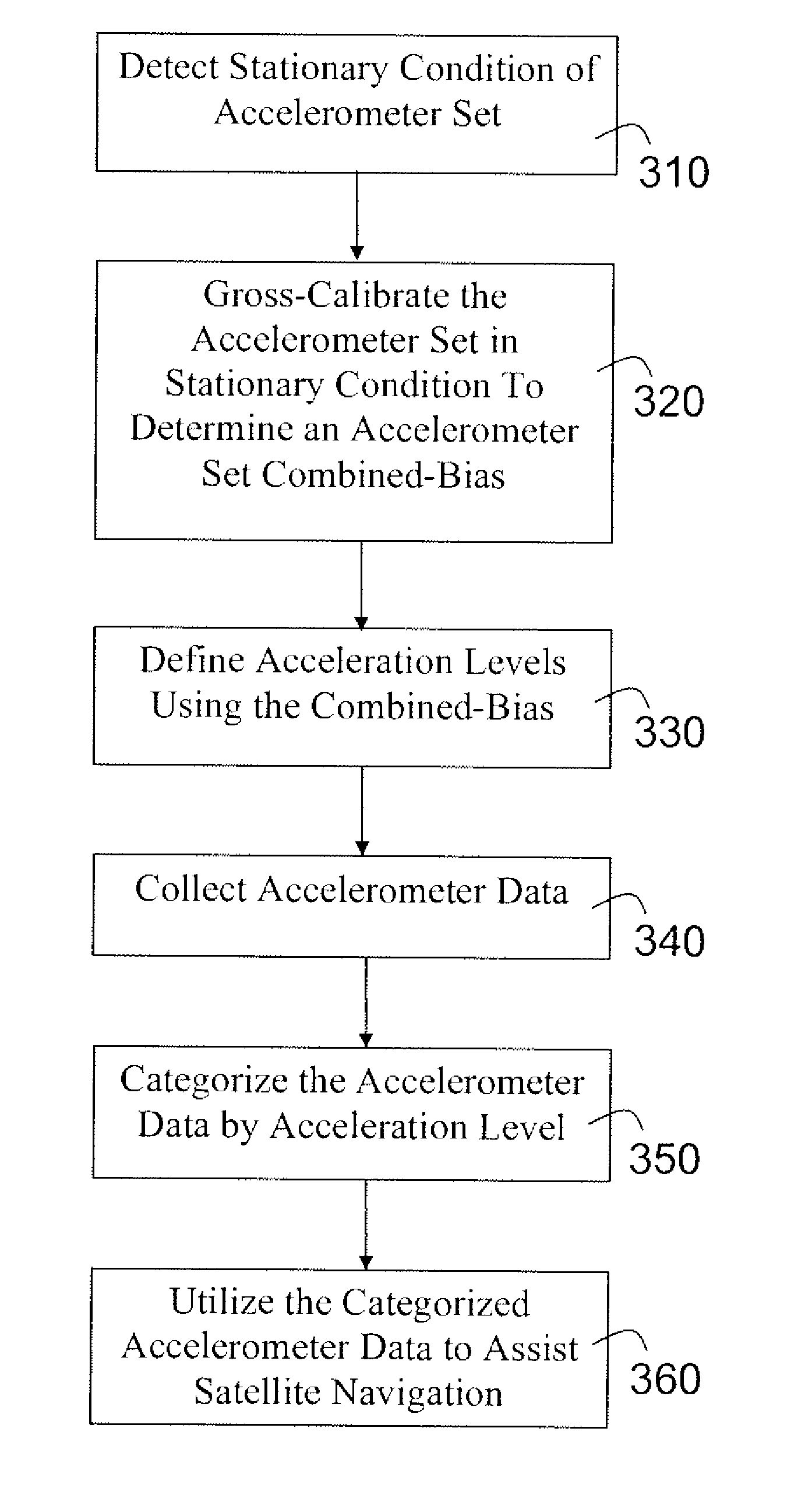
The present invention provides apparatus and methods for improving satellite navigation by assessing the dynamic state of a platform for a satellite navigation receiver and using this data to improve navigation models and satellite tracking algorithms. The dynamic state of the receiver platform may be assessed using only accelerometer data, and does not require inertial navigation system integration. The accelerometers may not need to be very accurate and may not need to be aligned and / or accurately calibrated. A method of accelerometer assisted satellite navigation may comprise: detecting a stationary condition of an accelerometer set; gross-calibrating the accelerometer set when in the stationary condition, wherein gross-calibrating includes determining a combined-bias of the accelerometer set; defining at least two acceleration levels using the combined-bias; collecting accelerometer data; categorizing the accelerometer data into one of the acceleration levels; and utilizing the categorized accelerometer data to enhance satellite navigation.

Description

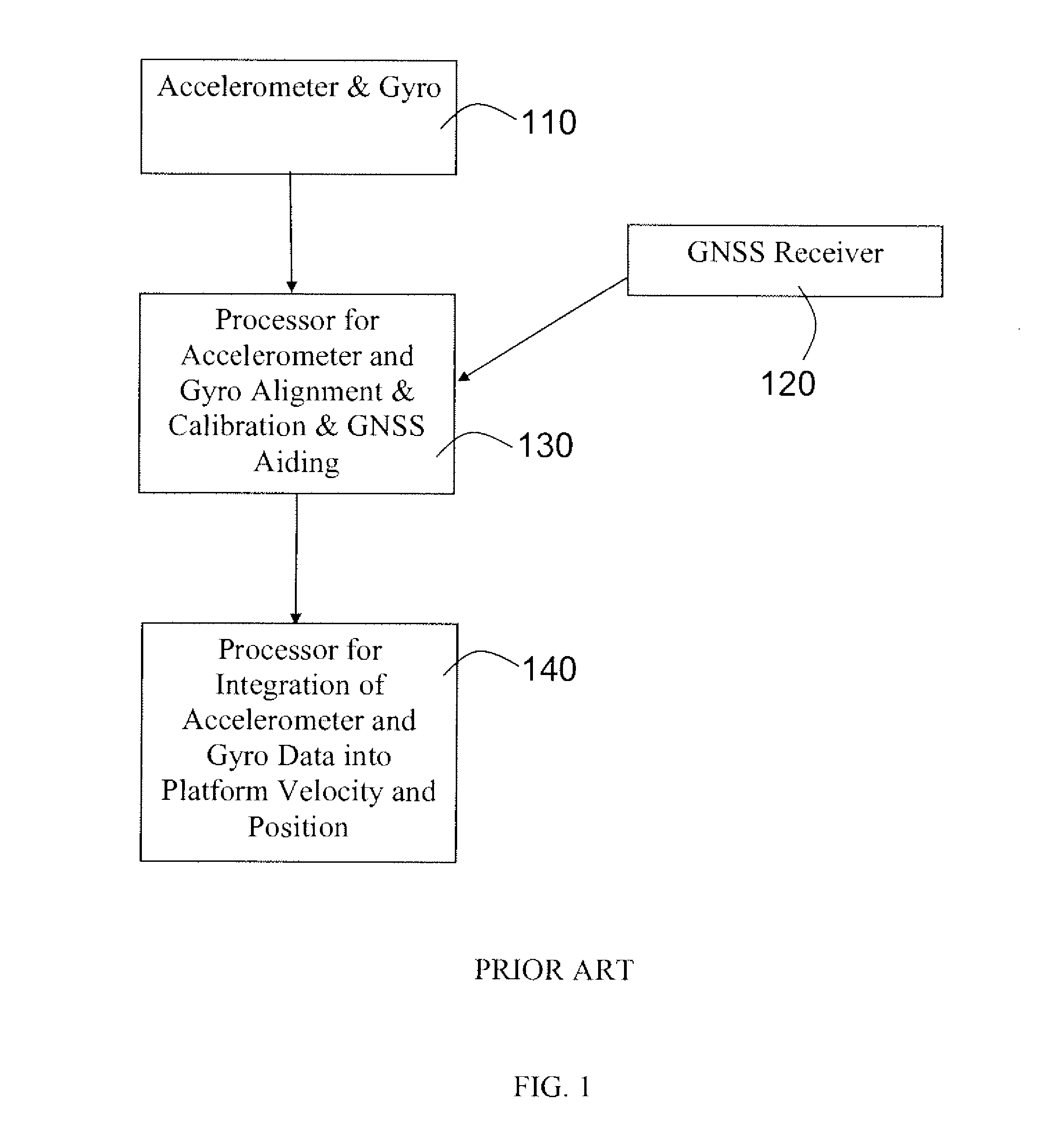
FIELD OF THE INVENTION[0001]The present invention is related to satellite navigation and tracking enhancement, and more particularly to using accelerometer-only data from uncalibrated and unaligned accelerometers to assist satellite navigation and tracking.BACKGROUND OF THE INVENTION[0002]The performance of Global Navigation Satellite Systems (GNSS), such as the Global Positioning System (GPS) and other satellite based navigational systems, may be enhanced by inertial navigation systems (INSs), which utilize inertial measurement units such as gyroscopes and accelerometers to measure changes in direction and acceleration. See FIG. 1. Other inertial measurements that may be used are car odometer readings, wheel ticks from car wheels, and angle of a car steering wheel. INSs may be integrated into a very wide range of satellite based navigation devices—e.g. personal navigation devices (PNDs), other hand held devices such as cell phones, and vehicle-based navigation devices.[0003]Many de...

Claims


Application Information

Patent Timeline
Patent Type & Authority Applications(United States)
IPC IPC(8): G01C21/00G01S19/47H04W64/00
CPCG01S19/26G01C21/28
Inventor CHANSARKAR, MANGESH
Owner CSR TECH HLDG
Learn More