
Navigation system

a navigation system and navigation system technology, applied in the direction of navigation instruments, maps/plans/charts, instruments, etc., can solve the problem that users cannot comfortably drive along the hov lan

Active Publication Date: 2011-09-22
MITSUBISHI ELECTRIC CORP
View PDF7 Cites 18 Cited by
  • Summary
  • Abstract
  • Description
  • Claims
  • Application Information

AI Technical Summary

Benefits of technology

The present invention is implemented to solve the foregoing problems. Therefore it is an object of the present invention to provide a navigation system capable of guiding a user through an HOV lane comfortably.
According to the navigation system in accordance with the present invention, since the information representing the HOV lane is added to the road number and is displayed during traveling in the HOV lane, it can cause a user to visually recognize in which road and where on the road the user is driving. As a result, it can give information that will enable the user to drive comfortably in the HOV lane.

Problems solved by technology

However, the conventional technology disclosed in the foregoing Patent Document 1 does not give information about the road number while taking an HOV lane into account, information about the remaining distance and remaining time as to the driving HOV lane, or information for displaying an entrance / exit section in a single link, thereby offering a problem in that a user cannot drive along the HOV lane comfortably.

Method used


Image

  • Navigation system
  • Navigation system
  • Navigation system

Examples


embodiment 1

A navigation system of an embodiment 1 in accordance with the present invention is configured in such a manner as to add information representing an HOV lane to a road number display during traveling in the HOV lane.

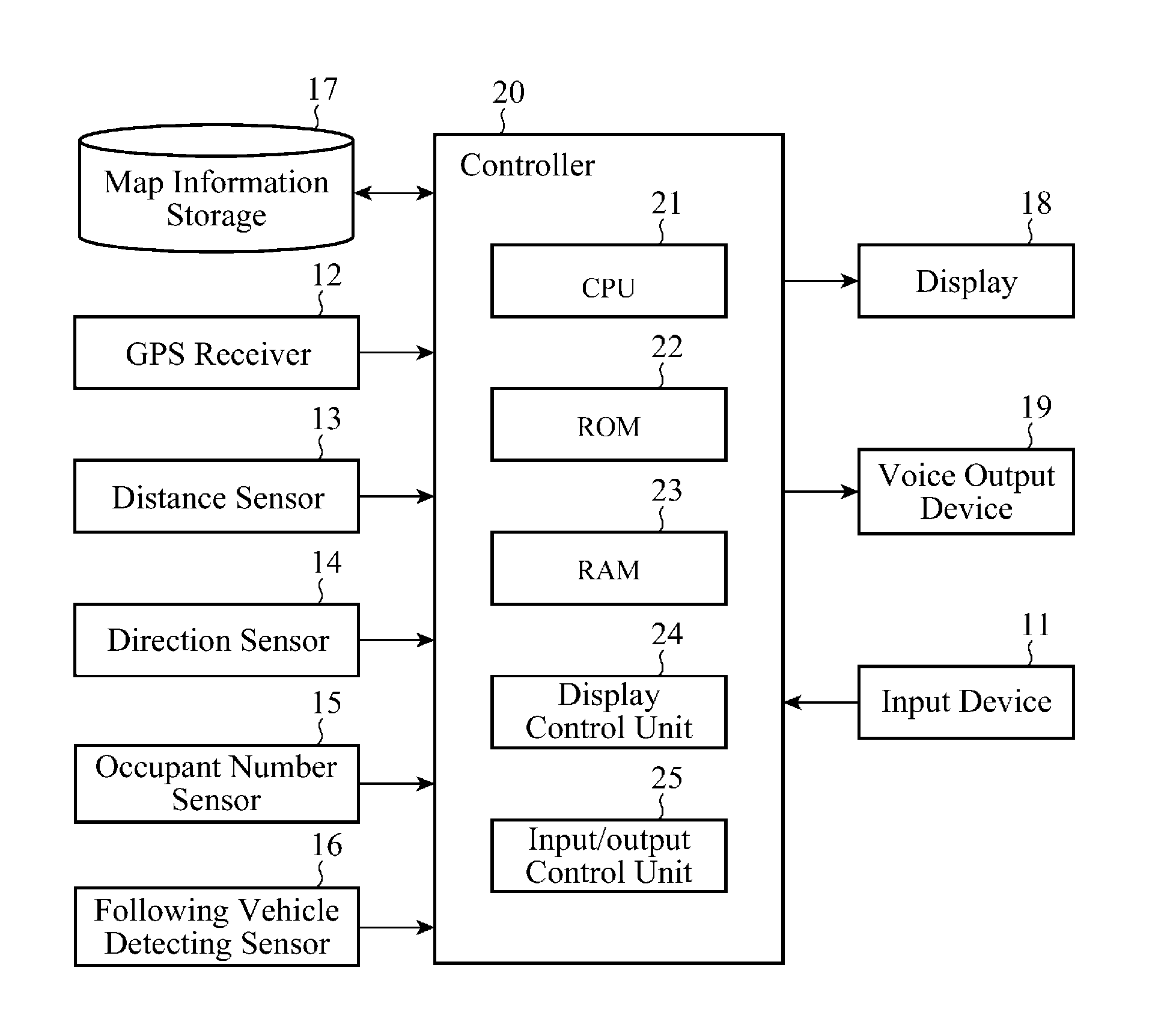
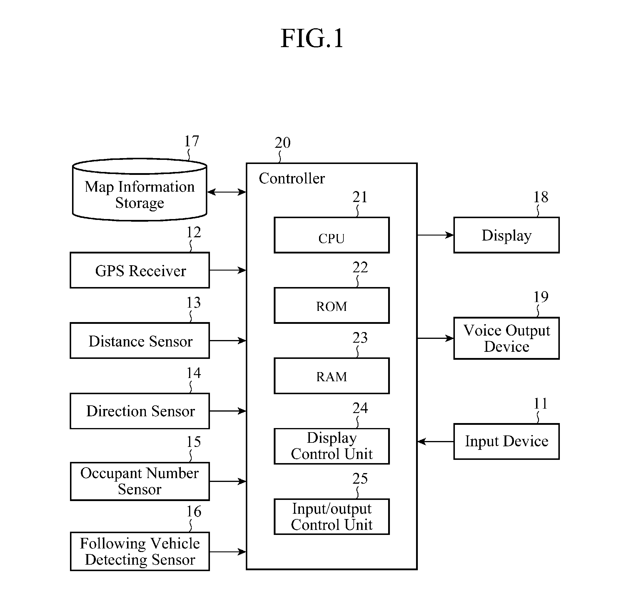
FIG. 1 is a block diagram showing a hardware configuration of the navigation system of the embodiment 1 in accordance with the present invention. The navigation system comprises an input device 11, a GPS (Global Positioning System) receiver 12, a distance sensor 13, a direction sensor 14, an occupant number sensor 15, a following vehicle detecting sensor 16, a map information storage 17, a display 18, a voice output device 19 and a controller 20.

The input device 11 comprises a touch panel mounted on the screen of the display 18, for example. The input device 11 is used for inputting a starting place, a destination or places passed through for a route search, or used for a user to provide the navigation system with a variety of instructions. The information input from the...

embodiment 2

The navigation system of an embodiment 2 in accordance with the present invention is configured in such a manner that while driving in the HOV lane, it adds information representing an HOV lane to a road number display and outputs, and that even if the link data representing a road does not contain the road number, in particular, it extracts the road number from the road name, adds the information representing the HOV lane to the road number it extracts, and displays it.

The configuration of the navigation system of the embodiment 2 in accordance with the present invention is the same as that of the navigation system of the foregoing embodiment 1. The following description will be made centering on differences (in operation) from the navigation system of the embodiment 1.

As for an HOV dedicated lane (HOV dedicated road), there are some cases where a link representing the road does not contain its road number, but contains only its road name. In addition, as for the road number, there...

example 3

Northern Part of I-95N)

Road Name: Unavailable

Road Number: I-395 HOV LN

(b) Mixed Road of HOV Lane and FWY (Freeway) Lane

EXAMPLE 1

East Side of Los Angeles

Road Name: Unavailable

Road Number: I-110 N

EXAMPLE 2

West Side of Los Angeles

Road Name: Unavailable

Road Number: I-405 N

(c) Road with Only FWY Lane


PUM


Abstract

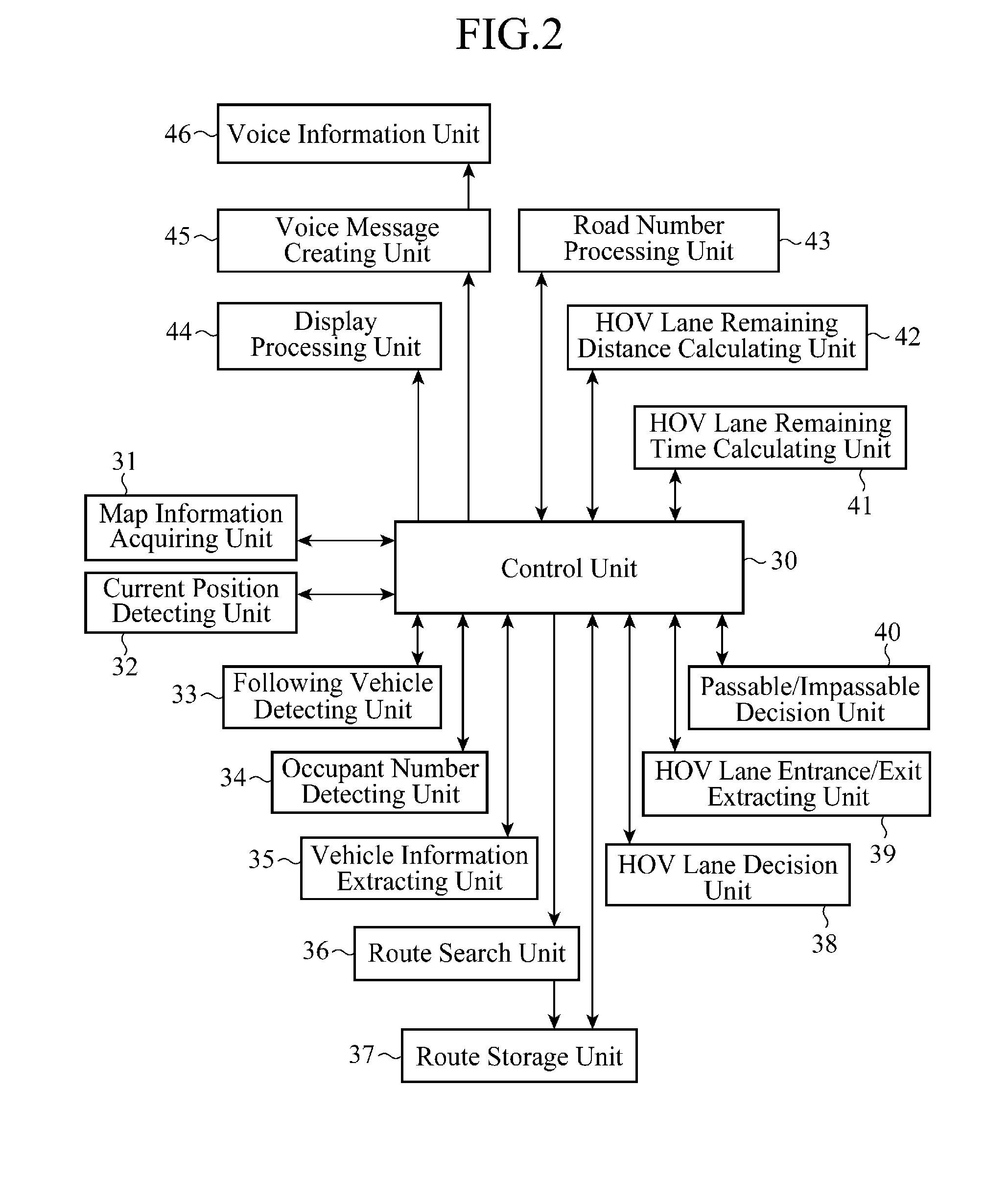
A navigation system includes: a map information acquiring unit 31 for acquiring map information; an HOV lane decision unit 38 for deciding whether an HOV lane is included in a road represented by the map information acquired by the map information acquiring unit 31 or not; a road number processing unit 43 for performing, when the HOV lane decision unit 38 decides that the HOV lane is included, processing of adding information representing the HOV lane to a road number of the road including the HOV lane; and a display processing unit 44 or a voice information unit 46 for causing the road number passing through the proces sing by the road number processing unit 43 to be displayed on the guide map or output in voice.

Description

TECHNICAL FIELDThe present invention relates to a navigation system for guiding a user to a destination, and particularly to a technique for guiding while taking an HOV lane (High Occupancy Vehicle Lane) into account.BACKGROUND ARTConventionally, as a road that regulates entrance of vehicles, a carpool lane has been known which is employed by a road system mainly seen in large cities in North America. The carpool lane, which is also called an HOV lane, is a lane that allows only vehicles with two or more passengers to travel. As an example of the carpool lane, a lane provided on a highway, a lane that short-cuts an interchange and the like are known. A road system that employs the carpool lane encourages a plurality of passengers to get on the same vehicle by giving preferential treatment to them of being able to arrive at a destination in a shorter time by driving along the carpool lane, thereby trying to reduce a volume of traffic to alleviate traffic congestion.As a technique for...

Claims


Application Information

Patent Timeline
Patent Type & Authority Applications(United States)
IPC IPC(8): G01C21/36
CPCG01C21/3658G09B29/007G01C21/3629G01C21/34G09B29/10
Inventor NISHIBASHI, KUMIIRIE, TAKASHI
Owner MITSUBISHI ELECTRIC CORP
Learn More