Mapping soil hardness

a soil hardness and mapping technology, applied in geological measurements, reradiation, sowing, etc., can solve the problems of time-consuming and costly soil testing, and insufficient packing of furrows, so as to save maps with very little cost and effor

Inactive Publication Date: 2012-05-24
STRAW TRACK MFG
View PDF1 Cites 33 Cited by
  • Summary
  • Abstract
  • Description
  • Claims
  • Application Information

AI Technical Summary

Benefits of technology

[0017]The hardness of the soil is an indicator of soil type, soil texture, and other characteristics that are beneficial in mapping management zones, and the map can be saved with very little cost and effort by simply recording and storing the information as the seeding implement operates normally. In comparison for example, developing a map of the soil conductivity used by Hanson to generate management zones requires a separate operation of moving a soil conductivity sensor across the field.

Problems solved by technology

Thus soil testing is a time consuming and costly process.
Soil conditions can vary considerably from field to field and also within a single field and so the packing force varies considerably with the result that in some areas of the field the furrows are over-packed while in other areas the furrows are not sufficiently packed.

Method used


Image

  • Mapping soil hardness
  • Mapping soil hardness
  • Mapping soil hardness

Examples


Embodiment Construction

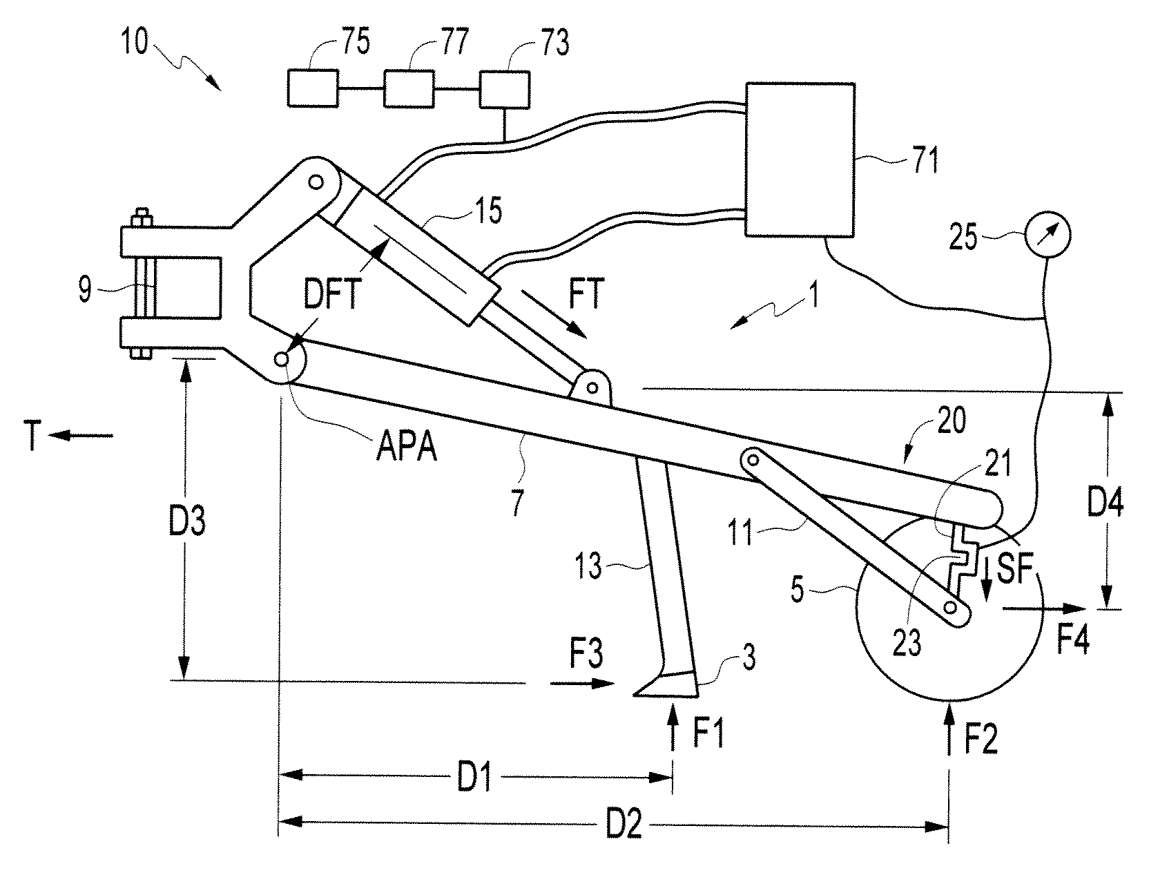
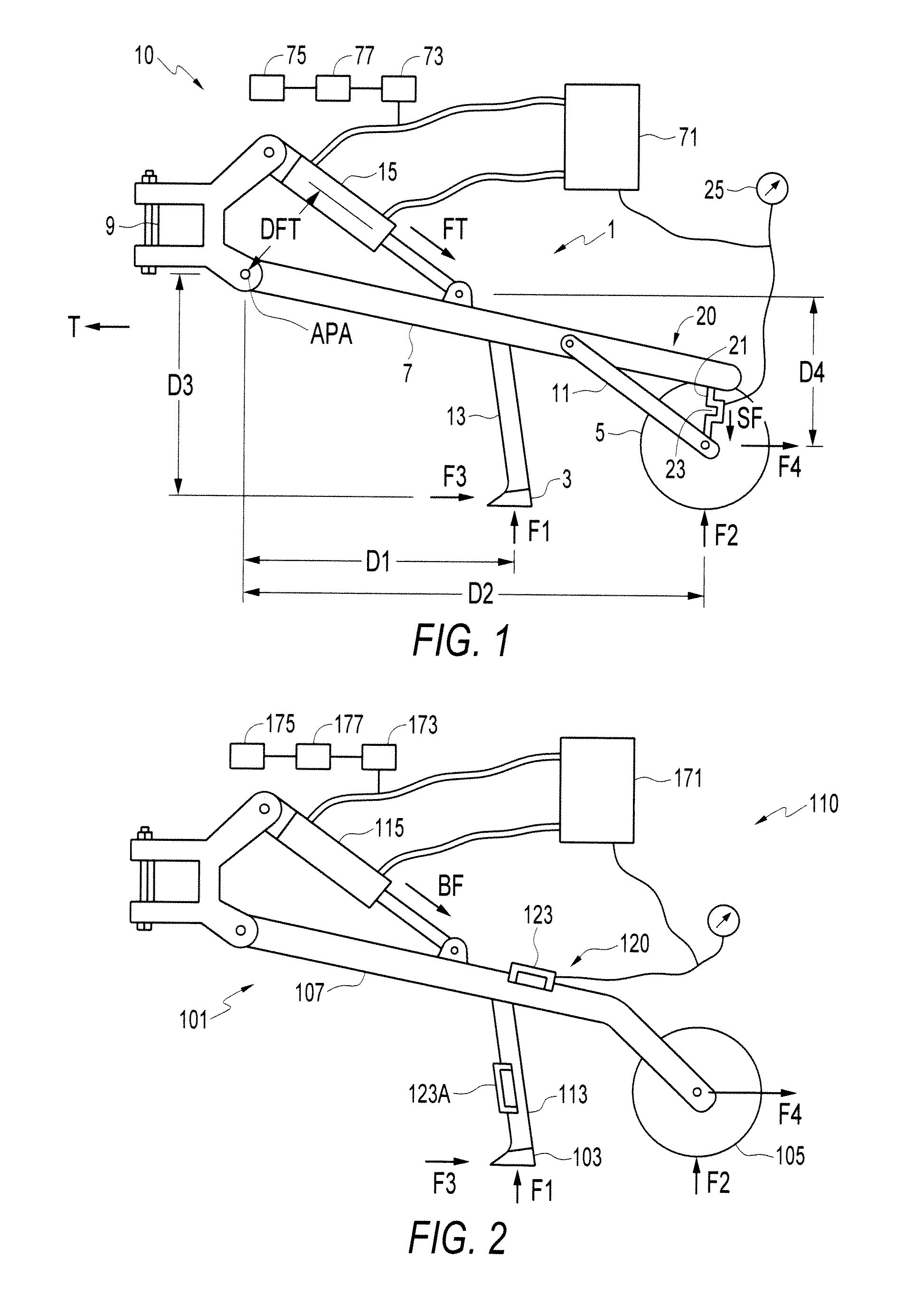
[0028]FIG. 1 illustrates a schematic side view of an embodiment of apparatus of the present invention for mapping resistance of soil to a ground engaging tool passing through the soil. The apparatus comprises a sensor mechanism operative to measure a resistance force exerted on the ground engaging tool by the soil, an external guidance system operative to determine a location of the ground engaging tool, and a microprocessor operative to receive information from the sensor and external guidance system and operative to plot the force against the location of the ground engaging tool as the ground engaging tool moves along the ground to form a map showing hardness of the soil as indicated by a varying value of the force.

[0029]In the apparatus of the present invention is illustrated as an agricultural seeding apparatus 10 where the ground engaging tool is a furrow opener 3. In the embodiment the apparatus 10 also maintains the packing force exerted by a packer wheel 5 on a furrow in a d...


PUM


Abstract

An apparatus for mapping resistance of soil to a ground engaging tool passing through the soil includes a sensor mechanism operative to measure a resistance force exerted on the ground engaging tool by the soil, and an external guidance system operative to determine a location of the ground engaging tool. A microprocessor receives information from the sensor and external guidance system and plots the force against the location of the ground engaging tool as the ground engaging tool moves along the ground to form a map showing hardness of the soil as indicated by a varying value of the force.

Description

[0001]This invention is in the field of agricultural soil mapping and in particular mapping soil hardness.BACKGROUND[0002]Historically in agriculture, a field had to be treated as a whole when deciding fertilizer and seeding rates, since these rates needed to be set on the seeding implement for the field, and could not be changed as the implement moved across the field. The rates were only changed when moving from one field to another if such a change was warranted.[0003]External guidance systems for agricultural field operations, most commonly using guidance signals from the global positioning system (GPS) but sometimes also guidance signals from more local radio towers or the like, allow an operator to determine the location of an implement in a field. This ability has led to the development of field mapping, where the field is divided into management zones, and seeding implement have been developed with the ability to vary application rates for crop inputs like seed and fertilize...

Claims


Application Information

Patent Timeline
Patent Type & Authority Applications(United States)
IPC IPC(8): A01C5/06G06F19/00G01V9/00
CPCA01C7/205A01B79/005
Inventor BEAUJOT, NORBERT
Owner STRAW TRACK MFG
Why Eureka
Try Eureka