Inertial Navigation Units, Systems, and Methods

a technology of navigation units and inertial navigation, applied in the direction of distance measurement, navigation instruments, instruments, etc., can solve the problems of parabolic growth of position error, total convergence, and degraded inertial navigation performance, so as to improve the accuracy of navigation data

Active Publication Date: 2012-09-06
MSA TECH
View PDF2 Cites 15 Cited by
  • Summary
  • Abstract
  • Description
  • Claims
  • Application Information

AI Technical Summary

Benefits of technology

[0011]Accordingly, the present invention provides an inertial navigation system and unit, and associated methods that address or overcome certain drawbacks and deficiencies existing in known inertial navigation systems and units. Generally, the present invention provides an inertial navigation system and unit, and associated methods that lead to accurate system initialization. Preferably, the present invention provides an inertial navigation system and unit, and associated methods that are useful in connection with existing and available inertial sensor systems, such as a consumer-grade inertial sensor. Preferably, the present invention provides an inertial navigation system and unit, and associated methods that aid the inertial navigation system. Preferably, the present invention provides an inertial navigation system and unit, and associated methods that improve the accuracy of the navigation data generated by the inertial navigation system. Preferably, the present invention provides an inertial navigation system and unit, and associated methods that selectively use specific force data from multiple accelerometers to: initialize certain components of the inertial navigation system, generate navigation data, assist the navigational components of the system, and / or correct information and data used in connection with one or more routines within a navigation algorithm of the system.

Problems solved by technology

While certain aiding measurements can mitigate alignment error, mathematical constraints may prevent total convergence.
Further, error in attitude degrades inertial navigation performance by introducing error in the integration of total acceleration, which requires knowledge of the system attitude, the local gravity vector, and Coriolis force.
These errors compound into the velocity estimate, and further into the position estimate, such that error growth in position is parabolic in nature.
Due to the mathematical relationship between accelerometer biases, noise, and tilt error, it is difficult and often impossible to initialize the attitude precisely.
Specifically, such measurements provide limited observability for use in estimating the tilt error in the attitude estimate.
Further, no physical measurements of velocity, position, or attitude are available to aid the navigation algorithm or its various routines, and / or to effectively improve performance of the inertial navigation unit.

Method used


Image

  • Inertial Navigation Units, Systems, and Methods
  • Inertial Navigation Units, Systems, and Methods
  • Inertial Navigation Units, Systems, and Methods

Examples


Embodiment Construction

)

[0027]It is to be understood that the invention may assume various alternative variations and step sequences, except where expressly specified to the contrary. It is also to be understood that the specific devices and processes illustrated in the attached drawings, and described in the following specification, are simply exemplary embodiments of the invention. Hence, specific dimensions and other physical characteristics related to the embodiments disclosed herein are not to be considered as limiting.

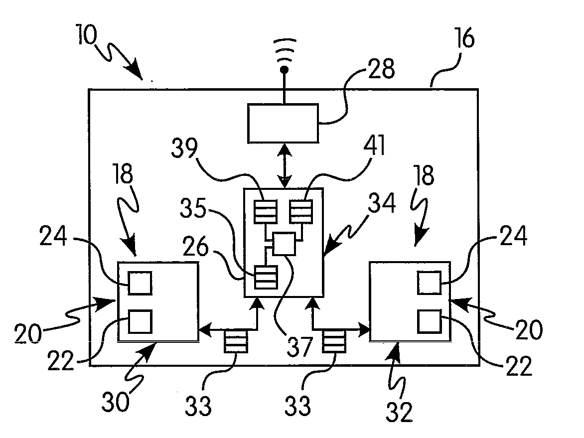
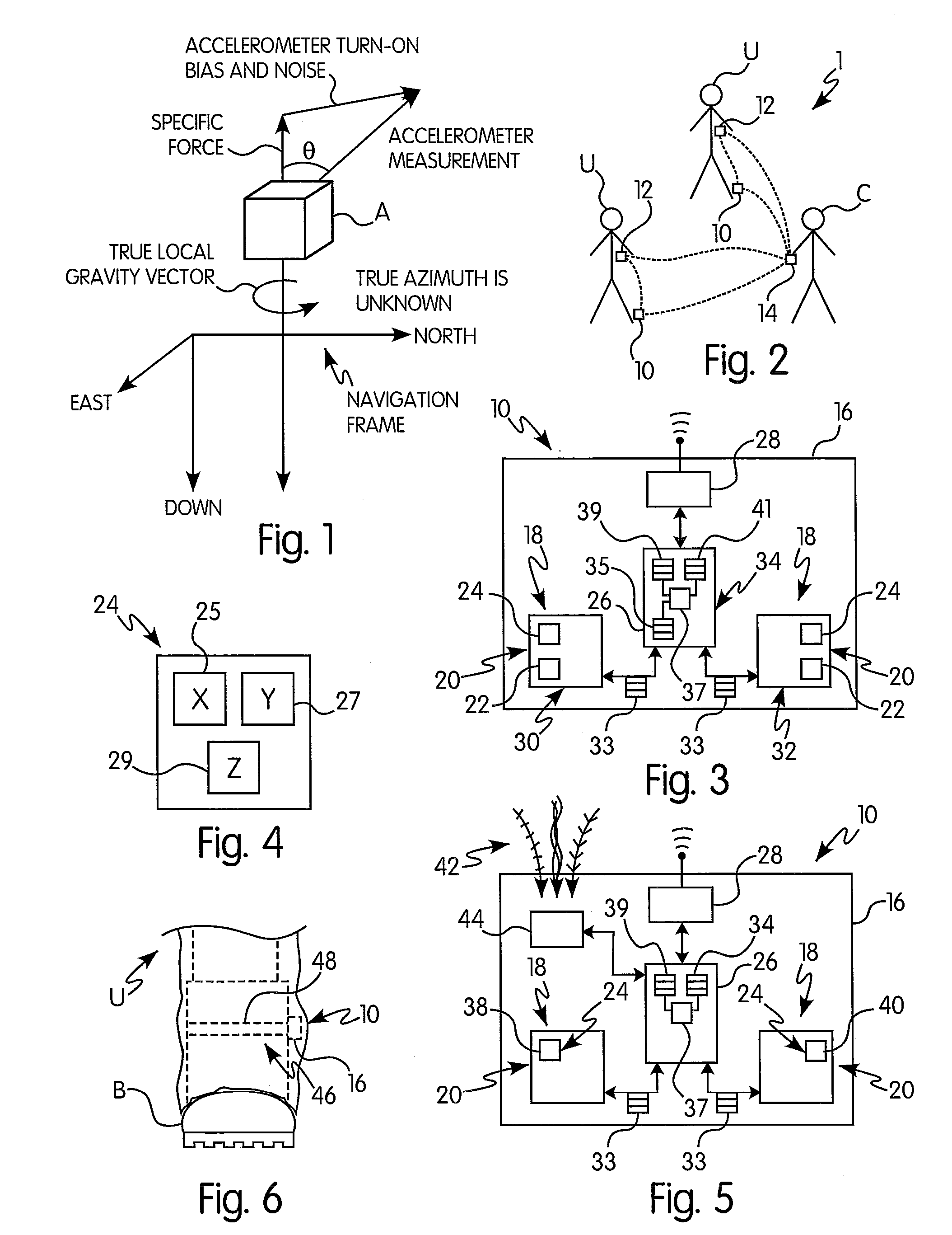
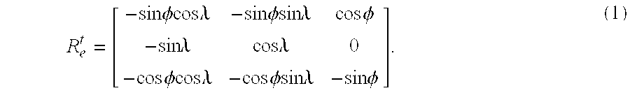
[0028]As discussed hereinafter, an initial consideration in the field of navigation is the reference frames, or coordinate systems, and their relationships between each other. These reference frames include the inertial frame i, the Earth-centered, Earth-fixed frame e, a north-east-down tangent frame t, and the body frame b. The inertial frame i is Earth-centered with the z axis parallel to the Earth's spin axis and passing through the North Pole. This reference frame is non-rotating, ...


PUM


Abstract

Navigation units, systems, and methods for use in the context of personal navigation, and associated methods for initialization, navigation, assistance, and correction, all in the field of inertial navigation and related applications. The inertial navigation units, systems, and methods of the invention utilize multiple accelerometers to gather specific force data for improvement of the initialization, navigation, assistance, or corrective processes.

Description

BACKGROUND OF THE INVENTION[0001]1. Field of the Invention[0002]The present invention relates generally to navigational units, systems, and methods used in positioning applications, and in particular to inertial navigation units, systems, and methods for initialization, navigation, assistance, and correction, all in the field of inertial navigation and related applications.[0003]2. Description of the Related Art[0004]The present invention relates generally to units, systems, and methods of determining the location of mobile personnel and, particularly, to units, systems, and methods of determining the location of personnel working under specific conditions outdoors and / or within one or more structures. One type of navigating platform and architecture is an inertial navigation system (INS), which is a navigational aid that uses a computer (or controller) and certain sensors to continuously calculate, via dead reckoning, the position, orientation, and velocity of a moving object witho...

Claims


Application Information

Patent Timeline
Patent Type & Authority Applications(United States)
IPC IPC(8): G06F15/00G01P15/00
CPCG01C22/006G01C21/16G01C21/166
Inventor MILLER, PAUL ALANTRAUTZSCH, THOMAS ANDREAS
Owner MSA TECH
Why Eureka
Try Eureka