
System and method for polythene infrastructure monitoring

Active Publication Date: 2015-06-04
ABU DHABI WATER & ELECTRICITY AUTHORITY ADWEA
View PDF2 Cites 9 Cited by
  • Summary
  • Abstract
  • Description
  • Claims
  • Application Information

AI Technical Summary

Benefits of technology

The patent is about a mobile laser scanning system that is capable of accurately positioning itself in at least three directions. This ensures that the system can move smoothly and without bumping into objects. The benefits of this system are that it can capture laser pulses more accurately and smoothly, improving the overall quality of the data collected by the system.

Problems solved by technology

When a certain user requires electrical or water maintenance due to a service disconnection, the normal workflow is to disconnect the service for all the nearby users due to an inaccurate / incomplete utility data.
The reason behind a lack of knowledge regarding the location of the utility services is the difficulty in surveying the daily network utility updates using the current surveying technologies.
The data collection performance by using the available surveying techniques on the city scale is very much limited and complicated due to several factors such as a lack of a proper geodetic network for establishing the needed missions control points before conducting the physical data collection operations.
On the other hand, the needed resources are also too huge to operate these techniques in the areas where the accuracy of the data is affected and not consistent due to the large number of resources involved with different quality levels.
The daily updates of the infrastructure networks are very huge due to the new installations, frequent replacements and enforcements that are subject to maintenance and operation on a frequent basis.
Due to the huge daily updates of the infrastructure networks, the ability of collecting the updated locations using the current geospatial monitoring techniques is very difficult.

Method used


Image

  • System and method for polythene infrastructure monitoring
  • System and method for polythene infrastructure monitoring
  • System and method for polythene infrastructure monitoring

Examples


Embodiment Construction

[0011]The primary object of the embodiments herein is to provide an improved system and method for monitoring the infrastructure networks using mobile laser based survey technology.

[0012]Another object of the embodiments herein is to provide efficient geospatial data updating system for the infrastructure networks.

[0013]Yet another object of the embodiments herein is to provide an analytical analysis method for identifying the most efficient system ground speed to be conducted during the mobile laser scanning missions for pipelines / cables.

[0014]Yet another object of the embodiments herein is to provide a system working on any kind of polyethylene infrastructure materials.

[0015]Yet another object of the embodiments herein is to provide a mathematical method for re-planning the mobile laser scanning missions to obtain the best model for updating the polyethylene infrastructure networks

[0016]These and other objects and advantages of the present invention will become readily apparent fr...


PUM


Abstract

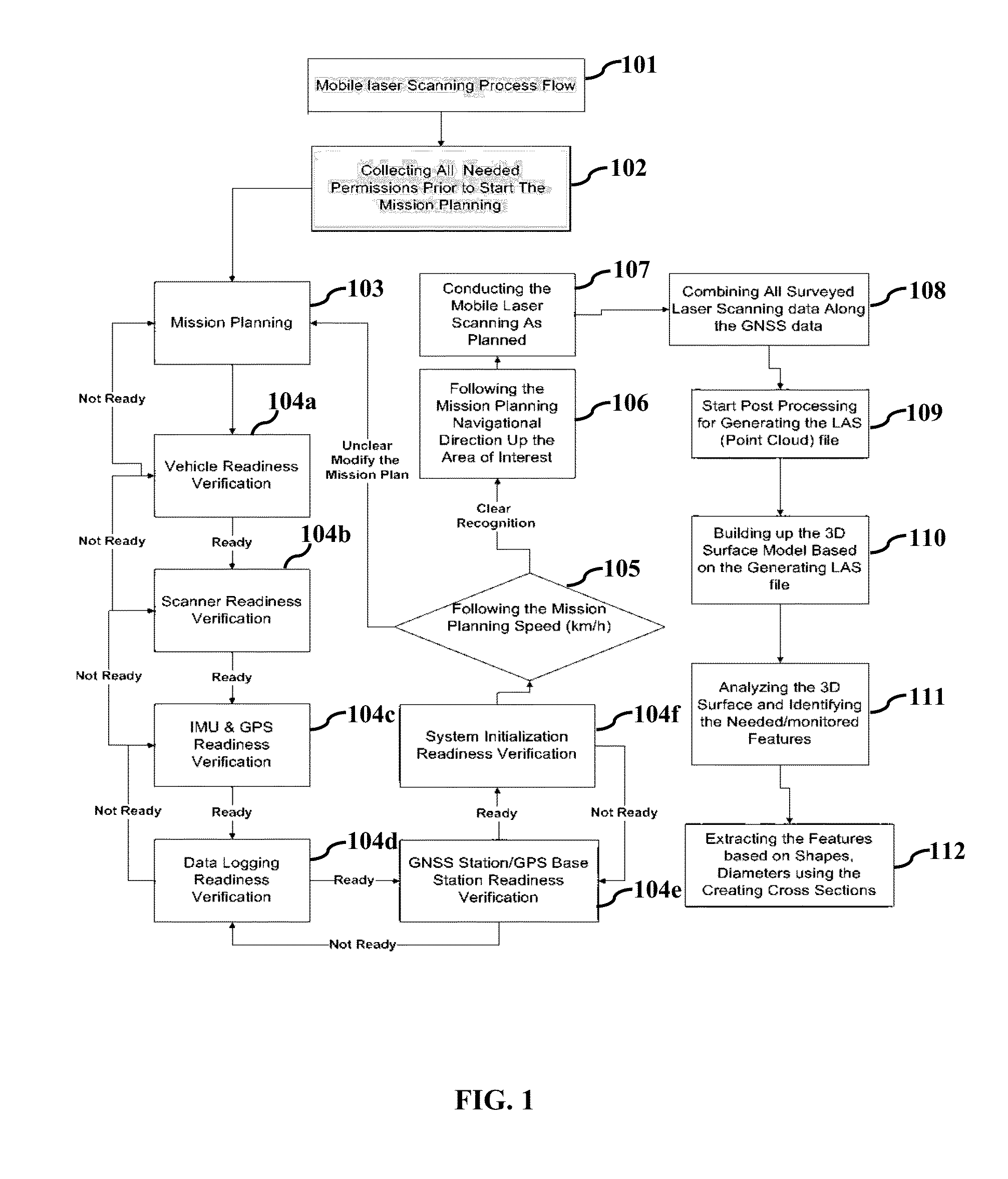
The various embodiments herein provide a method and system for obtaining geospatial data on infrastructure networks. The system comprises mobile laser scanner mounted on top of a vehicle with Global Positioning System, a floating inertial measurement unit and cameras. The method of mobile laser scanning process comprises verifying all components of laser scanning system for their functionality after collecting permissions; performing real data validation of the laser scanner; conducting mobile laser scanning by transmitting and receiving laser pulses; correcting the geometrical errors using GNSS reference data; generating LAS file by combining surveyed laser data and GNSS data; constructing 3D surfaced based model; analyzing the surface model and extracting the layout of polyethylene infrastructure to observe the diameter and shape of the polyethylene pipes using the equationS=Prm×726.357708.38.

Description

[0001]The present invention claims priority of the Provisional Application No. 61 / 733,494 filed on Dec. 5, 2012.BACKGROUND[0002]1. Technical Field[0003]The embodiments herein generally relate to infrastructure networks. The embodiments herein particularly relates to a method for monitoring infrastructure networks. The embodiments herein more particularly relates to a method and system employing laser pulses for monitoring infrastructure networks.[0004]2. Description of the Related Art[0005]Over the past few years, several research and development authorities across the world have started the development and support of intelligent city platforms in terms of monitoring and controlling infrastructure networks. The infrastructure network is one of the primary city subsystems. The automation techniques are important to update the huge network with frequent progress interns of new installations, enforcements and replacements. The necessity of the infrastructure progress updates daily is g...

Claims


Application Information

Patent Timeline
IPC IPC(8): G01S17/89
CPCG01S17/89G01C15/002
Inventor AL-HADER, MAHMOUD FAWZI ABDULLAH
Owner ABU DHABI WATER & ELECTRICITY AUTHORITY ADWEA
Features
  • Generate Ideas
  • Intellectual Property
  • Life Sciences
  • Materials
  • Tech Scout
  • Unparalleled Data Quality
  • Higher Quality Content
  • 60% Fewer Hallucinations
Learn More