However, because of a small
field angle, a limited exploration range, the presence of shielding in view, and the like, some information will be lost since it fails to be imaged onto an
image plane, and the requirements of the super-close distance autonomous navigation cannot be met.
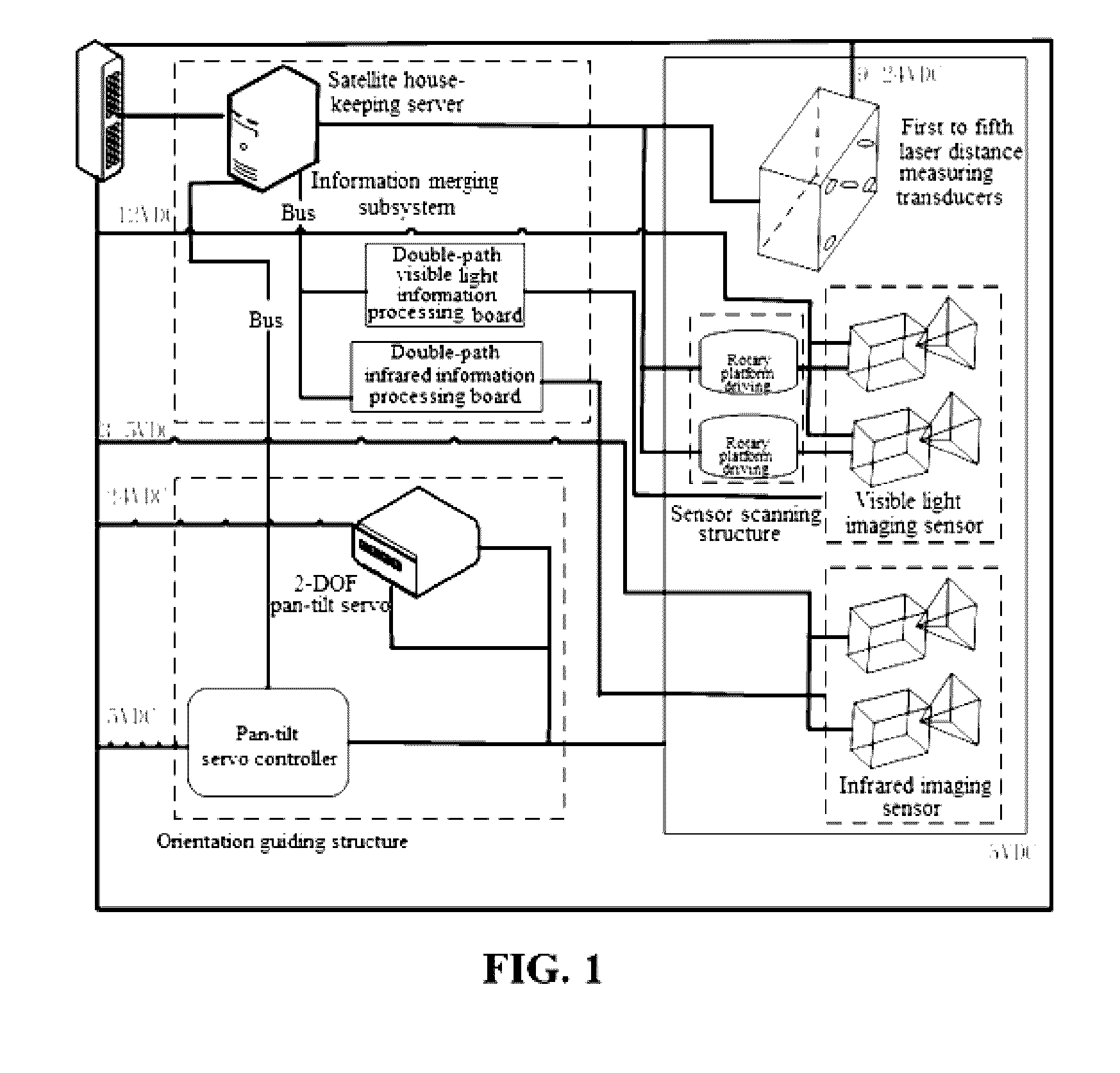
1. Through the combination of a visible light imaging sensor and an infrared imaging sensor, problems generated when only one navigation mode is used alone can be effectively solved.
First of all, the visible light imaging sensor can acquire morphological apparent information of a spatial object when being illuminated with light, and the imaging effect thereof is closest to the human eyes' vision, so that the information on a visible light image is the most intuitive, and the most interested. For example, some
angular point information, edge information, topological structure, and the like are all morphological features on which algorithms depend largely. However, in the case where the light condition is not ideal, or there is no light, the morphological features included in a visible light image may not be complete or there is no morphological feature exists in the visible light image, in some cases, a pseudo feature may even appear, which brings difficulties to the realization of pretreatment and
algorithm reconstruction. The present invention makes up for the above defects of the visible light imaging sensor through the infrared imaging sensor. The spatial object may not be illuminated under the
sunlight, but as long as it is in operation, the internal engine and processor thereof would radiate heat outwards, and imaging would occur on an infrared camera. Moreover, when being irradiated under the
sunlight, the spatial object have different temperatures on a face facing to the
sunlight and a face opposite thereto, and an
infrared image can reflect some attitudes and surface features of the spatial object, which are supplementary to the morphological features in a visible light image.
Secondly, an
infrared image formed by an infrared imaging sensor has a low sharpness, the expression of the morphological feature of the object has a low integrity, and
feature extraction is difficult, while the present invention utilizes the obvious morphological feature of a visible light image formed by a visible light imaging sensor to make up for the above defects of an
infrared image.
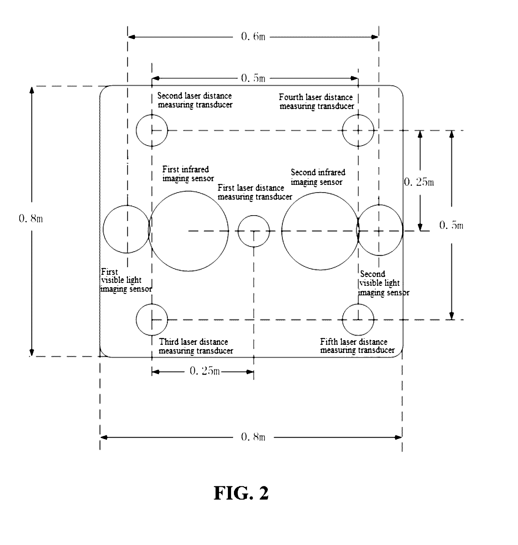
2. A navigation mode in which a binocular visible light imaging sensor, a binocular infrared imaging sensor, and a laser distance measuring
sensor array are combined is adopted, in combination with a passive measurement mode composed of an
optical imaging sensor and an
active measurement mode composed of a laser distance measuring sensor. Wherein, the autonomous navigation apparatus is equipped with an orientation guiding structure, the binocular visible light imaging sensor is equipped with a scanning structure, and the orientation guiding structure of the autonomous navigation apparatus can realize the adjustment of the range of the
field of view of the autonomous navigation apparatus, thereby solving the
small field of view, the limited exploration range, and other problems existing in the
monocular and binocular navigation, and the scanning structure of the binocular visible light imaging sensor effectively solves the problems such as shielding of the passive measurement navigation mode; as for the
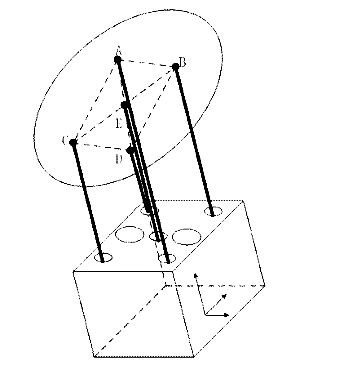
active measurement mode composed of the laser distance measuring sensor, the laser distance measuring sensor array simultaneously acquires the distance information of five feature points within a rectangular area on a measured surface of the spatial object, thereby avoiding the defects existing in the scanning mechanism, not only a
distance parameter of a target
satellite is obtained through
data processing, but also a surface morphology of the measured region can be fitted out through calculation, and especially for a close distance, real-
time distance information and
angle of inclination between a docking port plane of the navigation apparatus and a docking port plane of the spatial object can be obtained through analysis.
3. The autonomous navigation process can be completed substantially in three stages: a remote distance stage, implemented by adopting a navigation mode where a binocular visible light imaging sensor and a binocular infrared imaging sensor are combined, a close distance stage, implemented by adopting a navigation mode where a binocular visible light imaging sensor, a binocular infrared imaging sensor and a laser distance measuring sensor array are combined, and an ultra-close distance stage, implemented by adopting a navigation mode of a laser distance measuring sensor array. Different components are adopted at different distances for data measurement, a navigation mode in which a variety of components are combined is adopted in the remote distance stage and in the close distance stage, thereby ensuring the precision of the data measurement, and improving the navigation efficiency and the safety and reliability of navigation.

