Landslide hazard assessment system and method

a hazard assessment and landslide technology, applied in the field of landslide hazard assessment system and method, can solve the problems of regional, real-time landslide hazard assessment is exceptionally difficult, and the timing of rainfall-triggered landslides is difficult to predict, so as to reduce the overall number of alerts, accurately resolve landslide nowcasts, and improve hazard analysis

Inactive Publication Date: 2018-02-15
NASA
View PDF0 Cites 58 Cited by
  • Summary
  • Abstract
  • Description
  • Claims
  • Application Information

AI Technical Summary

Benefits of technology

[0008]The program of the present invention estimates potential landslide activity across broad regions. While intense rainstorms are the most important trigger of landslides worldwide, landslides are often exacerbated by prior soil moisture conditions. Using antecedent daily rainfall has been shown to help predict landslides, especially those cases where the triggering precipitation event is prolonged but less intense.
[0009]In one embodiment, the program of the present invention integrates a regional landslide susceptibility map and satellite-based rainfall on a daily basis, as well as incorporates an antecedent rainfall index (ARI) to represent the conditions prior to the day of the triggering event. Since the relationship between rainfall, antecedent rainfall, susceptibility and landslide triggering is not linear, the program of the present invention employs a novel approach to accurately resolve landslide nowcasts while minimizing the overall number of alerts issued. In one embodiment, the program of the present invention may also incorporate other hydrological or atmospheric variables such as numerical weather forecasts or satellite-based soil moisture estimates, for improved hazard analysis.
[0010]In one embodiment, the availability of free satellite-based near real-time rainfall data allows the program of the present invention to be used in any study area with a spatiotemporal record of landslide events, and can be used with different hydro-meteorological and in situ data products.

Problems solved by technology

Landslides pose a serious threat to life and property in many regions of the world.
The timing of rainfall-triggered landslides is challenging to predict due to the scarcity of real-time precipitation measurements, in situ landslide inventories, and information about local ground conditions.
A regional, real-time landslide hazard assessment is exceptionally challenging due to the limited availability of in situ data on landslides, rainfall gauges (particularly in developing countries), and consistent surface variables like topography.
However, there have been few attempts to connect these two variables to give a near real-time estimate of potential landslide hazard areas at a regional scale.

Method used


Image

  • Landslide hazard assessment system and method
  • Landslide hazard assessment system and method
  • Landslide hazard assessment system and method

Examples


Embodiment Construction

[0040]The present invention relates to a computer program and system which allows regionally coordinated situational awareness with respect to landslides. The program of the present invention provides a new flexible framework for evaluating potential landslide activity in near real time.

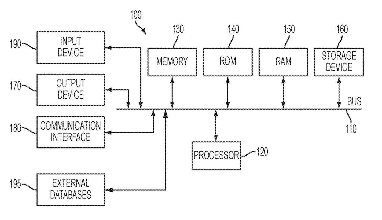
[0041]With reference to FIG. 1, an exemplary system includes a general-purpose computing device 100, including a processing unit (CPU) 120 and a system bus 110 that couples various system components including the system memory, such as read-only memory (ROM) 140 and random access memory (RAM) 150 to the processing unit 120. Other system memory 130 may be available for use as well. It can be appreciated that the invention may operate on a computing device with more than one CPU 120 or on a group or cluster of computing devices networked together to provide greater processing capability. A processing unit 120 can include a general purpose CPU controlled by software as well as a special-purpose processo...


PUM


Abstract

The present invention relates to a computer-implemented method of providing a landslide hazard assessment, including: inputting a region from which to retrieve geographic information from a database or from a user in real-time, using an input device of a computer system; retrieving geographic information from the database, on the region; retrieving satellite-based remote sensing data from the external database in real-time or near real-time from the region, the external database being accessed by the computer system over the internet; creating a susceptibility map which is divided into a plurality of categories that represent relative susceptibility to landslides; showing the plurality of categories on the susceptibility map on a display of the computer system, using a defining characteristic; comparing a current daily rainfall accumulation from the external database to a daily rainfall threshold; and issuing a moderate- or high-hazard level landslide nowcast, depending on a result of the comparison.

Description

BACKGROUND OF THE INVENTION1. Field of the Invention[0001]The present invention relates to a computer program and system capable of utilizing globally available satellite products for landslide hazard assessment. The present invention also provides a flexible framework to interchange the individual program components and adjust thresholds based on access to new data and calibration sources. In one embodiment, the program assigns thresholds to susceptibility, daily rainfall and antecedent rainfall, and based on the situation at a given pixel, issues on a predetermined basis—such as daily—either a high hazard, a moderate hazard or a null nowcast, of a predicted landslide.2. Description of the Related Art[0002]Landslides pose a serious threat to life and property in many regions of the world. The ability to estimate or forecast landslide activity is largely dependent on the scale at which the analysis is undertaken as well as the availability of geomorphologic, atmospheric and landslid...

Claims


Application Information

Patent Timeline
Patent Type & Authority Applications(United States)
IPC IPC(8): G01W1/06G01C21/00G08B21/10G01W1/14
CPCG01W1/06G01W1/14G06T11/60G08B21/10G01C21/005G08B31/00G09B29/00
Inventor KIRSCHBAUM, DALIASTANLEY, THOMAS A.CAPPELAERE, PATRICE
Owner NASA
Why Eureka
Try Eureka