Cooperative systems and methods for TDOA-based emitter location

a technology of electromagnetic radiation and co-operation, applied in the direction of direction finders, radio wave direction/deviation determination systems, instruments, etc., to achieve the effect of accurate resolution of signal arrival timing relationships

Inactive Publication Date: 2014-10-21
L 3 COMM INTEGRATED SYST
View PDF27 Cites 28 Cited by
  • Summary
  • Abstract
  • Description
  • Claims
  • Application Information

AI Technical Summary

Benefits of technology

[0008]Disclosed herein are systems and methods that may be implemented to determine the location of an emitter of electromagnetic radiation (e.g., RF signal emitter, visible light spectrum emitter, etc.) having an unknown location, using a cooperative TDOA-based location methodology. The cooperative TDOA-based location methodology (e.g., such as TDOA / TDOA, TDOA / FDOA, etc.) may be implemented using at least one cooperative transmitter that transmits a cooperative electromagnetic radiation (EM) signal from a known location that is received at multiple different EM sensing platforms that are also each of known location. Using the disclosed systems and methods, the known geolocation of the cooperative transmitter may be leveraged together with one or more signal timing characteristics of the cooperative EM signal to accurately resolve the signal arrival timing relationships between the different sensing platforms that is necessary to determine the location of another EM transmitter of unknown location.
[0009]Using the disclosed systems and methods, TDOA information of a signal of interest from a target EM emitter of unknown location may be gathered at multiple EM sensors configured as EM collection nodes located on different sensing platforms (e.g., such as aircraft platforms), and the location of the target emitter determined using a TDOA-based methodology that employs a cooperative approach to synchronize the timing between the multiple different sensing platforms, e.g., by enabling the solution of time difference between each of the collection nodes in one exemplary embodiment without the use of an external precision timing source such as a disciplined rubidium oscillator (DRO). In one exemplary embodiment, the disclosed systems and methods may be implemented in a manner to resolve the sensing platform timing relationships relative to the unknown signal of interest to be within two times of the error associated with the cross-correlation function, i.e., once for the unknown signal of interest and once for the cooperative signal. In at least some implementations, it is also possible to improve the precision of a final TDOA-based geolocation solution by observing discrepancies in the location accuracies of collection node receivers at the different sensing platforms may be observed in the data analysis (e.g., discrepancies such as the difference between the true actual latitude, longitude, and or altitude and the data reported by a local GPS receiver or inertial navigation system).
[0015]It will also be understood that in other embodiments the center frequency (fCADJ) of the TXadj signal may be placed within at least a portion of the sensor capture bandwidth and / or at a distance in frequency (Df) of less than about 1.5 times the sum of the bandwidth of TXunknown (BUNK) and TXadj (BADJ) in Hertz away from the center frequency (fCUNK) of the TXunknown signal and such that the TXadj signal creates substantially no interference with the TXunknown signal.
[0016]In an alternative embodiment, a TXadj signal may be placed farther away from the TXunknown signal in the frequency domain but at a specific frequency relative to the frequency of the TXunknown signal (e.g., placed at a harmonic of the TXunknown signal) where an image of the signal folds into a close relationship with the TXunknown signal. For example, the center frequency (fCADJ) of a TXadj signal may be placed at a frequency distance of greater than about 3 harmonics away from the center frequency (fCUNK) of the TXunknown signal, or alternatively placed at a frequency distance of from about 3 harmonics to about 8 harmonics away from the center frequency (fCUNK) of the TXunknown signal), or alternatively placed at a frequency distance of about three harmonics away from the center frequency of the TXunknown signal (fCUNK). In such an exemplary embodiment, known characteristics of the capture system (e.g., such as the total capture bandwidth) may be leveraged to enable a mathematical solution with reduced possibility of disrupting the TXunknown signal.
[0017]In one exemplary embodiment, the disclosed systems and methods may be implemented to geolocate an EM transmitter of unknown location using an airborne TDOA-based EM capture system that has an active transmitter to support the data transfer required to process EM signals captured at different airborne EM sensing platforms. In such an embodiment, the active transmitter may also be employed to transmit a cooperative EM signal, thus eliminating the need for a separate dedicated cooperative transmitter. Thus, the disclosed systems and methods may be implemented in such an embodiment with minimum additional expense over a conventional airborne TDOA-based EM capture system.
[0018]In another exemplary embodiment, the disclosed cooperative timing synchronization approach may allow a TDOA emitter location system to be implemented using a smaller and less bulky electronics payload than is typically required for conventional non-cooperative TDOA electronics payloads, and with less dependency on the raw accuracy of the timing signal generated by a given platform. In such an exemplary embodiment, the disclosed systems and methods may be implemented with less expense, and with a smaller size, weight and power (SWAP) profile than is required for conventional non-cooperative TDOA solutions.

Problems solved by technology

However, only one of these possible geolocations is real, the other possible geolocations in the set are purely mathematical solutions that are not the real location of the radio emitter.

Method used


Image

  • Cooperative systems and methods for TDOA-based emitter location
  • Cooperative systems and methods for TDOA-based emitter location
  • Cooperative systems and methods for TDOA-based emitter location

Examples


Embodiment Construction

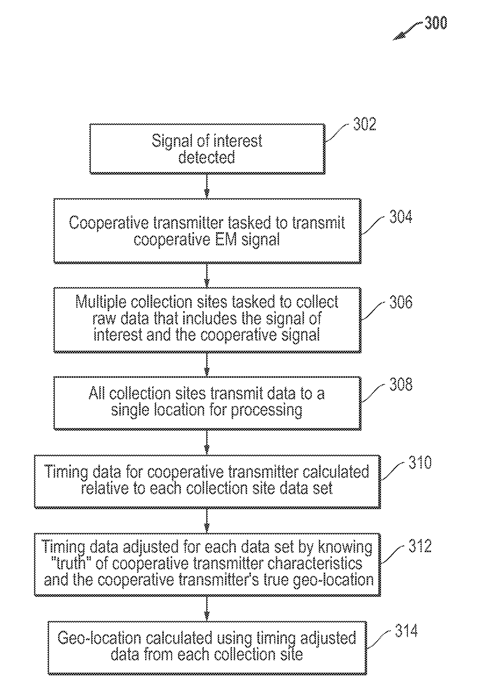
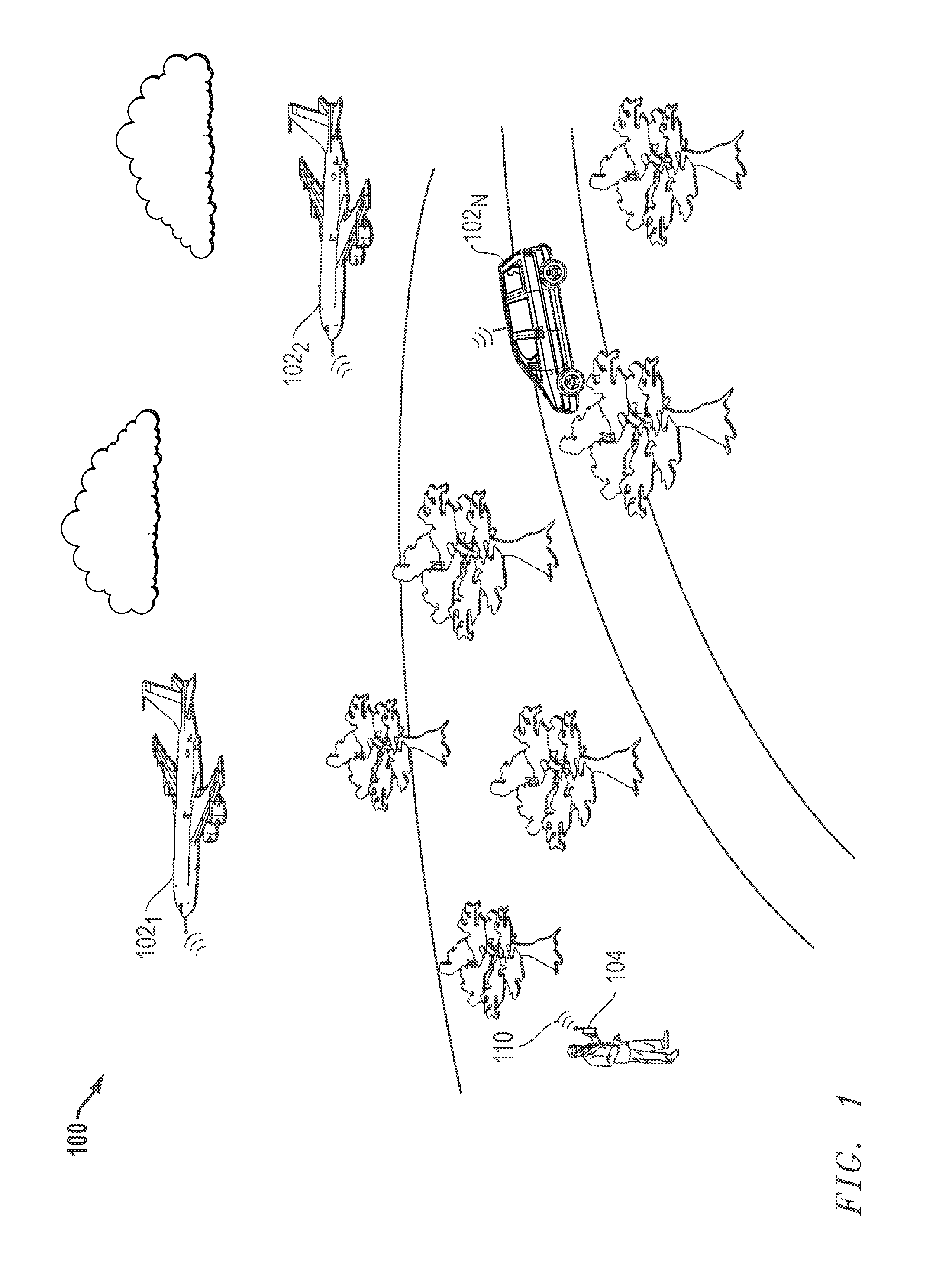
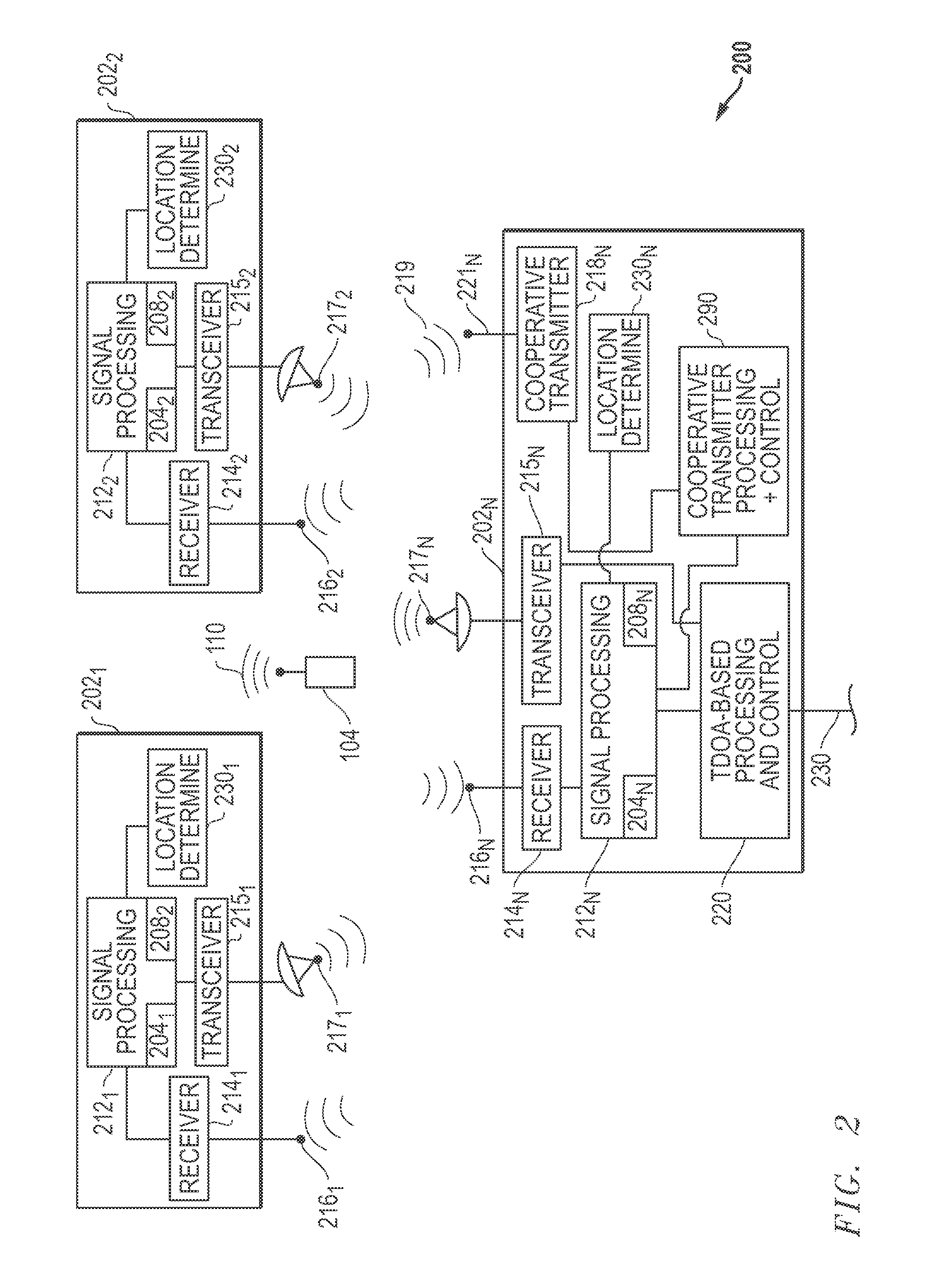
[0030]FIG. 1 illustrates one exemplary embodiment of an EM emissions environment 100 (in this case a radio communication environment) in which an emitter in the form of transmitter 104 at an unknown location is transmitting a target EM signal of interest 110 (TXunknown), e.g., in this case a radio frequency (RF) signal. In the illustrated embodiment, the illustrated emitter 104 is a ground-based mobile emitter (e.g., cell phone, push to talk radio, etc.) carried by a human being that is stationary and emitting from a fixed location. However, it will be understood that the disclosed systems and methods may be practiced in radio communication environments in which any type, number and / or combination of different types of emitters are transmitting on a one or more frequencies including, but are not limited to, base stations of a cellular telephone network, cell phone devices, weather broadcast stations, radar signal sources, microwave sources, etc. Furthermore, besides being hand carri...


PUM


Abstract

Systems and methods that may be implemented to determine the location of an emitter of electromagnetic radiation having an unknown location, using a cooperative TDOA-based location methodology. The cooperative TDOA-based location methodology (e.g., such as TDOA / TDOA, TDOA / FDOA, etc.) may be implemented using at least one cooperative transmitter that transmits a cooperative electromagnetic (EM) signal from a known location that is received at multiple different EM sensing platforms that are also each of known location. The known geolocation of the cooperative transmitter may be used to resolve the signal arrival timing relationships between the different sensing platforms that is utilized to determine the location of another EM transmitter of unknown location.

Description

BACKGROUND OF THE INVENTION[0001]1. Field of the Invention[0002]This invention relates generally to location of emitters of electromagnetic radiation, and in particular, to Time Difference of Arrival (“TDOA”)-based location of emitters of electromagnetic radiation.[0003]2. Description of the Related Art[0004]TDOA techniques have been employed in the past to determine the location of emitters of electromagnetic radiation, such as radio frequency (“RF”) emissions. Using the TDOA technique, the time difference (TDOA) in reception of a radio signal received at multiple spaced sensing platforms may be used to define a hyperboloid upon which the RF emitter of interest is located. TDOA may be used to calculate the geolocation of the RF transmitter if three or more sensing platforms simultaneously capture the radio signal, and if the difference in the times of arrival of the captured radio signal at the different sensing platforms can be accurately determined.[0005]Frequency difference (FDO...

Claims


Application Information

Patent Timeline
Patent Type & Authority Patents(United States)
IPC IPC(8): G01S3/16G01S1/04G01S5/06G01S5/02G01S5/00
CPCG01S5/0081G01S5/0221G01S5/06G01S1/04G01S5/02216
Inventor STROUD, KEN, A.
Owner L 3 COMM INTEGRATED SYST
Why Eureka
Try Eureka