
Estimating the speed and the heading of an aircraft, independently of a magnetic measurement

a technology of aircraft speed and direction, applied in the direction of speed/acceleration measurement, navigation instruments, instruments, etc., can solve the problems of pilots forgetting to switch into directional mode, the mode of operation cannot be used for more than a few tens of minutes, and the heading error due to the bias of the gyros

Active Publication Date: 2018-05-03
EUROCOPTER
View PDF0 Cites 10 Cited by
  • Summary
  • Abstract
  • Description
  • Claims
  • Application Information

AI Technical Summary

Benefits of technology

The present invention proposes a way to combine a GNSS receiver and an AHRS device to estimate the aircraft's ground speed and direction of flight, even if there are magnetic disturbances in the environment. This hybrid system is able to correct errors in the gyro estimate of the aircraft's direction and provide accurate and reliable results.

Problems solved by technology

Nevertheless, although it is possible for a land vehicle to consider that the route angle is generally equal to the heading, that is not true for an aircraft, which might fly with a certain amount of drift corresponding to the difference between the heading and the route angle.
Nevertheless, this mode of operation cannot be used for more than a few tens of minutes, since otherwise the heading error due to the bias of the gyros and appearing as drift will become prohibitive.
The difficulty with that type of heading estimator is that the pilot might forget to switch into directional mode before approaching a zone that is magnetically disturbed.
In contrast, such a heading estimate, which is continuously in directional mode, is affected by error that can be unlimited, including when the system is started.
For example, if the heading estimate is initialized on North while the nose of the aircraft is pointing south, then the error may be as great as 180°, even though the systems have only just been switched on.
The problem is thus to make use of a heading in permanent directional mode, which heading might therefore be affected by an error of amplitude that is unbounded, but that varies slowly.
Nevertheless, the use of extended Kalman filters is no more than an approximation to the process that is to be estimated, and is therefore not applicable when there might be large values of heading error.
Such a measurement device is considerably more expensive than an AHRS device with a magnetometer.
Furthermore, the time required for gyro alignment is much longer than the time required for magnetometer alignment, which can be detrimental for missions when initialization time is crucial.
Those solutions therefore do not satisfy the need for the piloting function of an aircraft to have an accurate estimate of its ground speed that is independent of magnetic measurements, that does not require the use of expensive inertial units, and that is not troublesome to use.

Method used


Image

  • Estimating the speed and the heading of an aircraft, independently of a magnetic measurement
  • Estimating the speed and the heading of an aircraft, independently of a magnetic measurement
  • Estimating the speed and the heading of an aircraft, independently of a magnetic measurement

Examples


Embodiment Construction

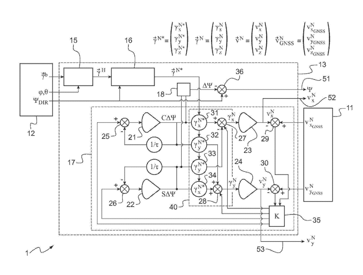
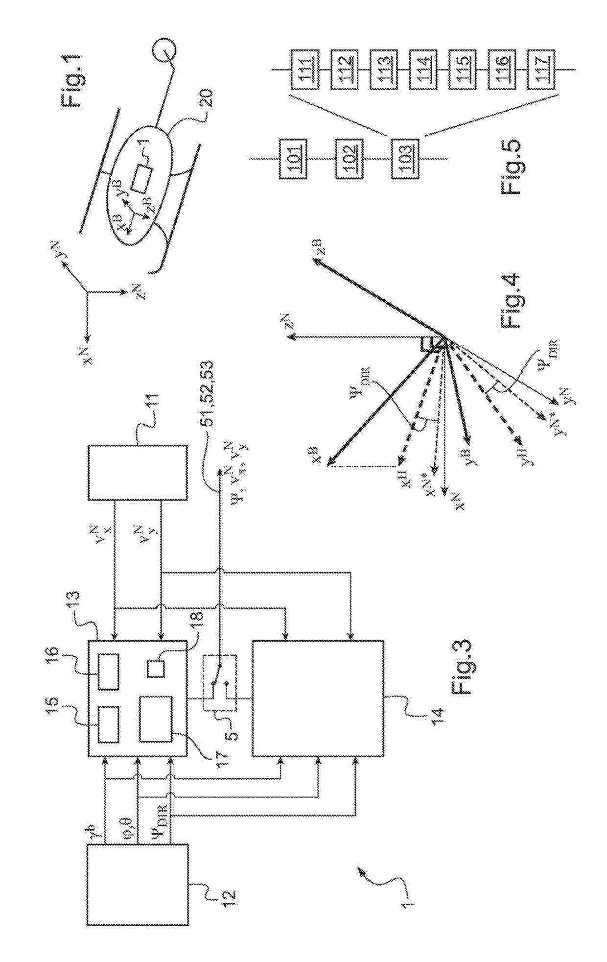
[0101]In FIG. 1, there can be seen a rotary wing aircraft 20. A fuselage reference frame (XB, YB, ZB) is rigidly associated with the aircraft 20, e.g. being attached to the mean center of gravity of the aircraft 20. The fuselage reference frame (XB, YB, ZB) is defined by particular directions of the aircraft 20, which are respectively the longitudinal direction XB contained in the plane of symmetry of the aircraft 20, parallel to the floor of the passenger cabin of the aircraft 20, and extending from the rear to the front of the aircraft 20, the normal direction ZB extending downwards perpendicularly to the longitudinal direction XB, and the transverse direction YB extending from left to right perpendicularly to the longitudinal direction XB and to the normal direction ZB. The longitudinal direction XB is the roll axis of the aircraft 20, the transverse direction YB is its pitching axis, and the normal direction ZB is its yaw axis.

[0102]A geographical reference frame (XN, YN, ZN) is...


PUM


Abstract

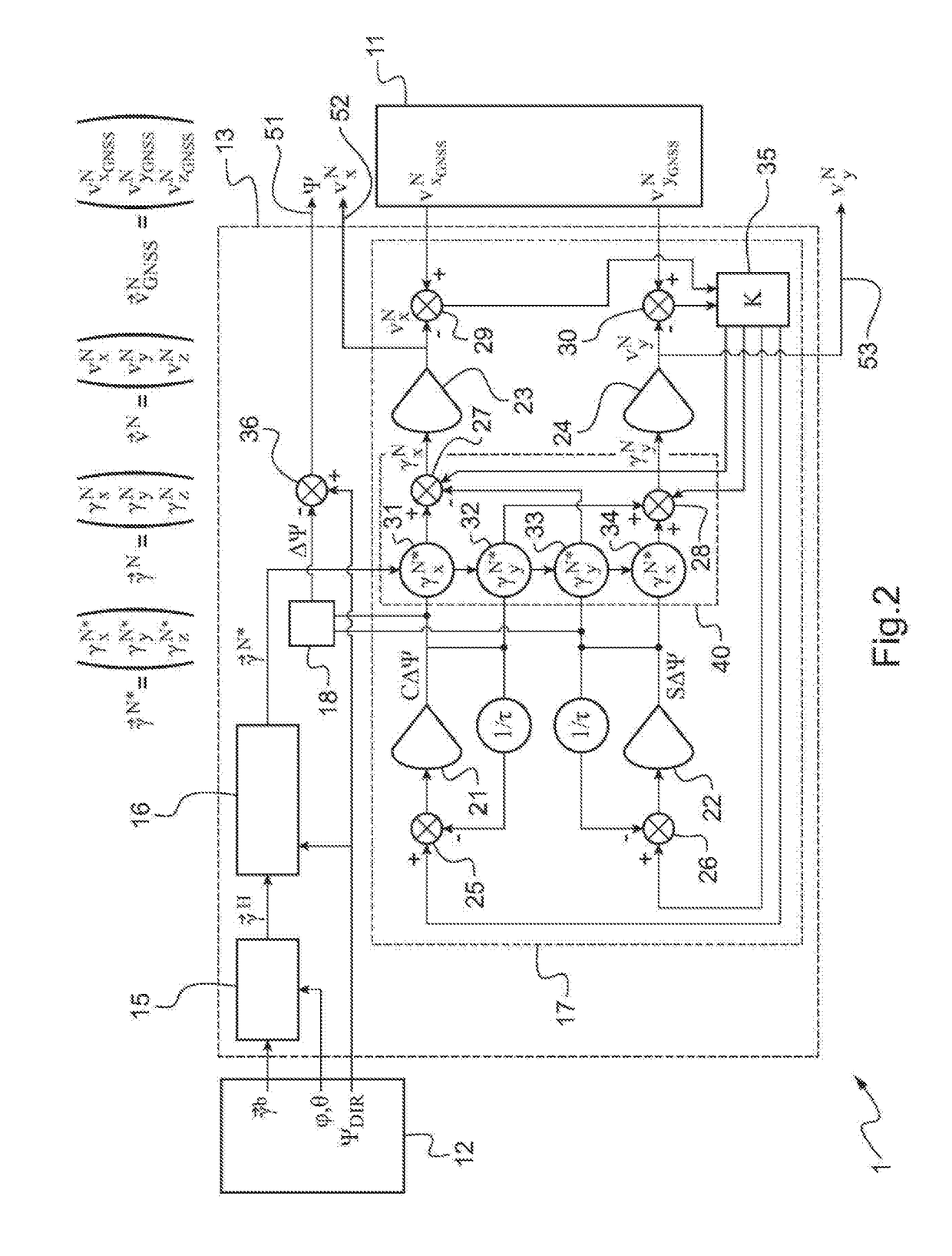
A device for estimating an aircraft's speed relative to the ground and heading, while making no use of the rotation of the Earth or of the Earth's magnetic field. The device comprises in particular a first linear estimator that hybridizes a measurement of the speed of the aircraft relative to the ground as provided by a GNSS receiver with measurements of the acceleration and the attitudes of the aircraft coming from an AHRS device without a gyrocompass and without a magnetometer. The first estimator is made linear by replacing the single “heading error estimate Δψ” state of prior art embodiments with two states, namely estimates of the sine and of the cosine of the heading error.

Description

CROSS-REFERENCE TO RELATED APPLICATIONS[0001]This application claims priority to French patent application No. FR 16 01555 filed on Oct. 27, 2016, the disclosure of which is incorporated in its entirety by reference herein.BACKGROUND OF THE INVENTION(1) Field of the Invention[0002]The present invention relates to the field of systems for providing assistance in piloting for aircraft. The present invention relates in particular to the field of piloting sensors for aircraft that deliver information about the speed relative to the ground and the heading of an aircraft in a reference frame that is associated with the aircraft in order to assist in piloting the aircraft.[0003]The present invention relates to a device for estimating the speed relative to the ground and the heading of an aircraft, and also to a method of estimating said speed and heading of the aircraft. The device and the method are independent of measuring the heading magnetically.(2) Description of Related Art[0004]In c...

Claims


Application Information

Patent Timeline
IPC IPC(8): G01C21/16G05D1/08B64D43/02G01C23/00
CPCG01C21/165G05D1/0825B64D43/02G01C23/005G01S19/49
Inventor PETILLON, JEAN PAULFLORENS, JULIEN
Owner EUROCOPTER
Learn More