
Location Correction through Differential Networks System

Active Publication Date: 2018-05-03
NASA
View PDF0 Cites 19 Cited by
  • Summary
  • Abstract
  • Description
  • Claims
  • Application Information

AI Technical Summary

Benefits of technology

The patent describes a way to make a mobile device with GPS work better in certain situations. This is done by using advanced GPS techniques and the low-quality hardware components of the mobile device. By improving GPS positioning, the mobile device can be used for applications that require more precise GPS information. This can include things like navigating to a destination or controlling a vehicle. Additionally, the mobile device can act as a response system, allowing users to conduct automated or manual activities based on their precise location.

Problems solved by technology

However, the functionality of the types of GPS receivers and associated chipsets typically used in modern mobile devices is limited by the reduced size, weight, power, and cost requirements of the receiving device.

Method used


Image

  • Location Correction through Differential Networks System
  • Location Correction through Differential Networks System
  • Location Correction through Differential Networks System

Examples


Embodiment Construction

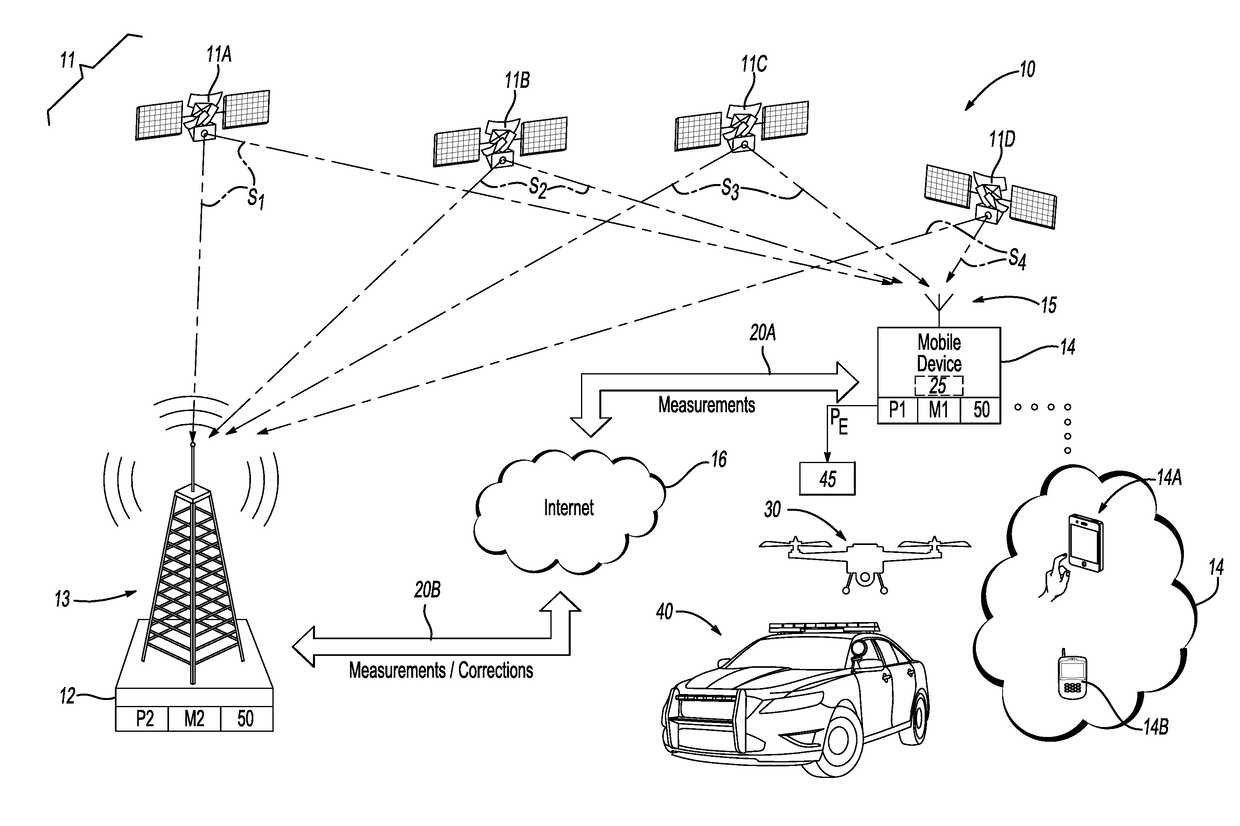
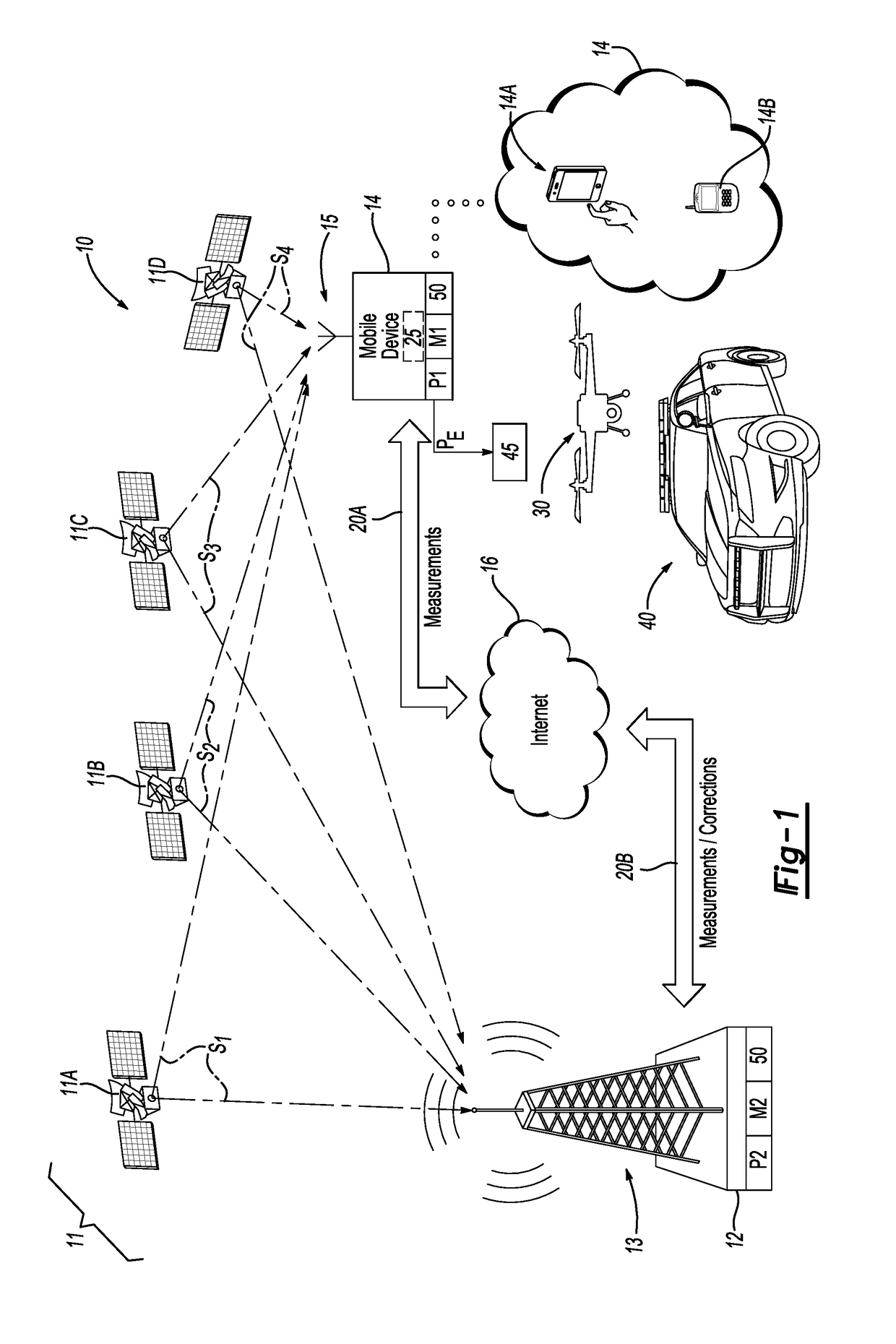
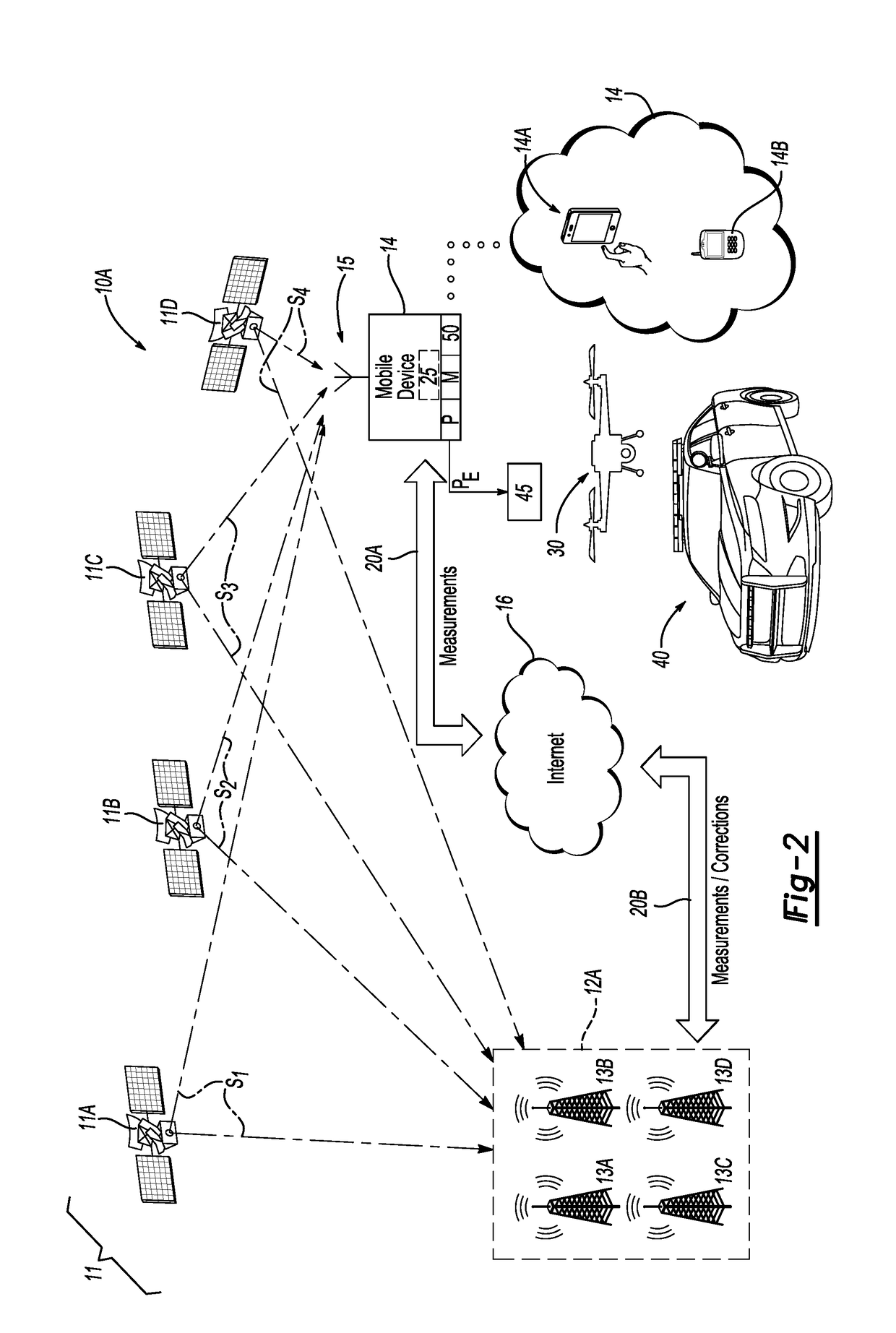
[0017]Disclosed herein are method and system for increasing global positioning system (GPS)-based position accuracy of internet-capable cell phones, tablet computers, or other mobile devices. The disclosed method takes advantage of available GPS data and other measurements such as pseudo-range, code phase, and / or carrier phase data, combined with corresponding GPS data and other measurement information provided over an internet or other wireless connection from one or more stationary base stations. For example, the method may take advantage of the Continuously Operating Reference Stations (CORS) operated by the U.S. National Geodetic Survey, and as typically used for positioning, meteorology, weather, and geophysical applications, or the Networked Transport of Radio Technical Commission for Maritime Services (RTCM) via Internet Protocol, i.e., the NTRIP protocol. The separate base station and mobile device data is processed using a predetermined GPS positional correcting technique, ...


PUM


Abstract

A method may be executed by a base station or mobile device to improve accuracy of a global positioning system (GPS)-based position or “geoposition” of the mobile device. A time-stamped first set of GPS data may be received via a GPS receiver, e.g., of the base station. A second set of GPS data describing a geoposition of the mobile device is received from the mobile device by the base station. A time of collection of the base station and mobile device GPS data coincides. The GPS data includes code phase and pseudo-range data from each of the GPS satellites, and may include carrier phase data. A predetermined GPS position correction technique is used to generate a corrected geoposition of the mobile device using the GPS data. The corrected geoposition is then transmitted to the mobile device and / or an external response system such as a drone or first responder.

Description

CROSS-REFERENCE TO RELATED PATENT APPLICATION[0001]This patent application claims the benefit of and priority to U.S. Provisional Patent Application No. 62 / 413,454, filed on Oct. 27, 2016, which is hereby incorporated by reference in its entirety.STATEMENT REGARDING FEDERALLY SPONSORED RESEARCH OR DEVELOPMENT[0002]The invention described herein was made by an employee of the United States Government and may be manufactured and used by or for the Government of the United States of America for governmental purposes without the payment of any royalties thereon or therefor.BACKGROUND OF THE INVENTION[0003]Mobile devices such as cell phones and tablet computers may be equipped with Global Positioning System (GPS) chipsets and receivers, and thus are able to use built-in GPS capabilities for a variety of beneficial purposes. GPS is a worldwide satellite-based navigation system that relies on an earth-orbiting constellation of satellites to facilitate precise geoposition identification of ...

Claims


Application Information

Patent Timeline
IPC IPC(8): G01S19/41G01S19/07G01S19/29
CPCG01S19/41G01S19/29G01S19/07G01S19/04G01S19/43G01S19/071
Inventor DILL, EVAN T.
Owner NASA
Learn More