Spaceborne synthetic aperture radar system and method

a technology of synthetic aperture radar and spaceborne, applied in the field of advanced spaceborne synthetic aperture radar (sar) system and method, can solve the problems of limited coverage and capability, high development cost, etc., and achieve the effect of removing timing disturbances and ambiguities

Active Publication Date: 2019-04-04
NASA
View PDF5 Cites 21 Cited by
  • Summary
  • Abstract
  • Description
  • Claims
  • Application Information

AI Technical Summary

Benefits of technology

[0006]The present invention relates to an advanced spaceborne Synthetic Aperture Radar (SAR) system and method, that can provide high resolution measurements of the Earth's or a planetary body's surface, overcoming limitations inherent in conventional SAR systems, and reducing the development cost. The present invention is applicable to a number of science and commercial applications areas including the measurement of ecosystem structure and extent, surface and sub-surface topography, soil freeze-thaw, ice sheet composition and extent, glacier depth, and surface water, among many others.
[0007]The present invention relates to a Synthetic Aperture Radar (SAR) that enables feasible and affordable spaceborne instruments that meet or exceed science needs by the science and commercial remote sensing community. The architecture of the present invention incorporates advancements in radar technology and techniques making this radar capable of imaging modes not possible with conventional radars. The present invention radar's innovative architecture is based on a multi-channel, modular, low power, lightweight design approach that permits system customization for different mission scenarios where the orbit parameters vary (e.g., missions to Earth, the Moon or Mars).
[0009]The present invention includes software program-defined multichannel-waveform generators, multi-channel data processors, digital beamforming, onboard radar processing, broadband and high-polarization isolation array antennas, and lightweight / low power RF hardware designs.
[0010]In one embodiment, advanced features of the present invention include software program-defined beam steering (no phase-shifters, no moving parts), beam pattern control, imaging both sides of the track, selectable incidence angles, and selectable range resolution, an increase in the measurement swath (area) without degrading the measurement resolution, and the suppression of ambiguities or localized interference in the receiver signal by appropriate null-steering of the antenna pattern. In one embodiment, the antenna gain, beam pointing angle, and sidelobe structure can be programmed in real-time for specific tasks. Furthermore, multiple beams can be synthesized on both sides of the flight-track, as well as nadir, using a single nadir-looking antenna (no moving parts), thus increasing the coverage area.
[0020]In one embodiment, each of the plurality of waveform generators residing at each of the FGPAs of the plurality of subarray RDUs, creates a trigger signal which is distributed to each of the plurality of subarrays, and synchronized by a radar pulse repetition frequency (PRF), such that the plurality of subarrays digitizes and processes radar signals, to remove timing disturbances and ambiguities caused by noise and part tolerances.
[0032]In one embodiment, the method further includes: creating a trigger signal using each of the waveform generators residing at each of the plurality of FGPAs of the plurality of subarray RDUs; and distributing the trigger signal to each of the plurality of subarrays, and synchronizing the plurality of subarrays by a radar pulse repetition frequency (PRF), such that the plurality of subarrays digitize and process radar signals, to remove timing disturbances and ambiguities caused by noise and part tolerances.

Problems solved by technology

A number of spaceborne SAR instruments are being operated today, but suffer from the disadvantages of limited coverage and capability, as well as a high development cost.

Method used


Image

  • Spaceborne synthetic aperture radar system and method
  • Spaceborne synthetic aperture radar system and method
  • Spaceborne synthetic aperture radar system and method

Examples


Embodiment Construction

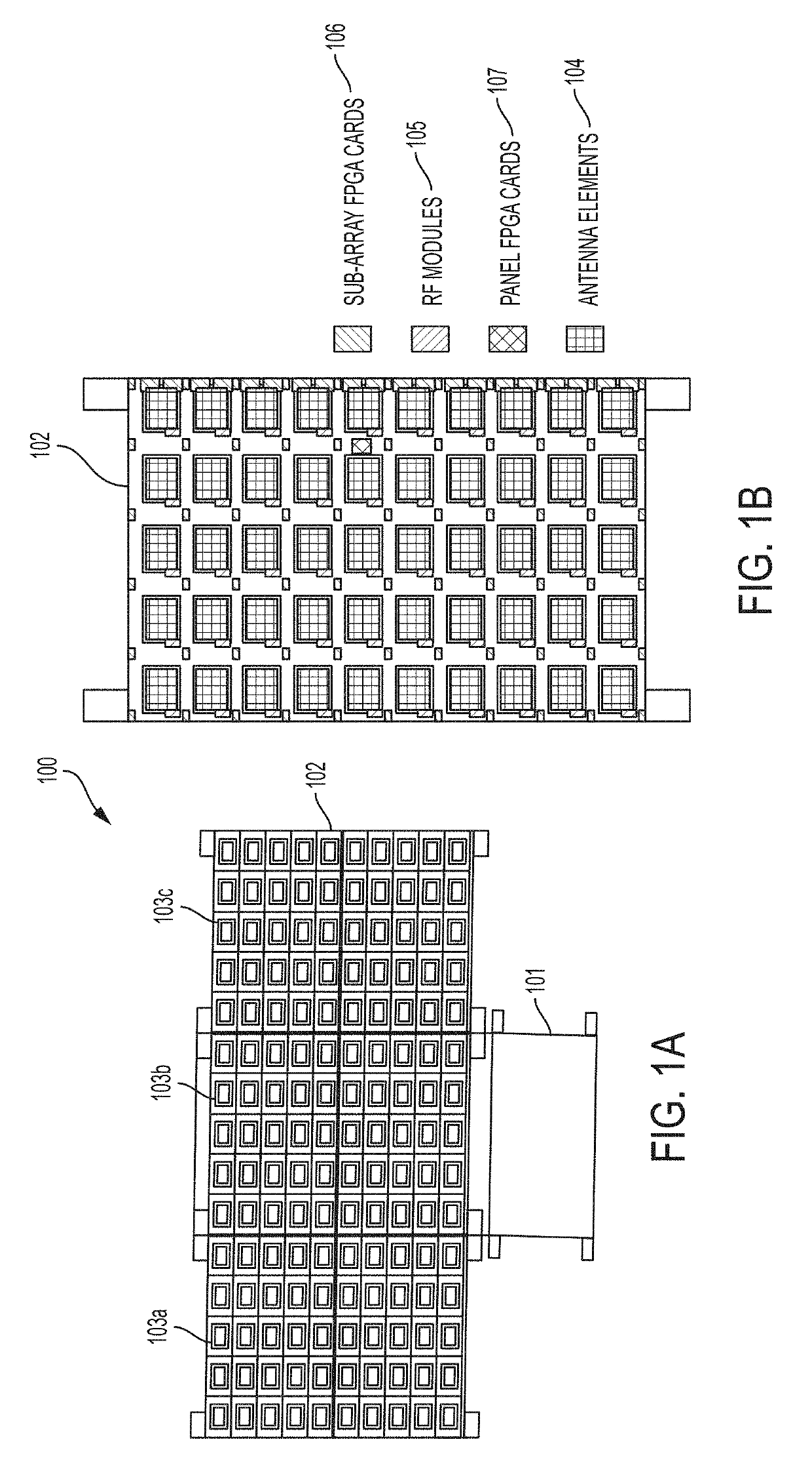
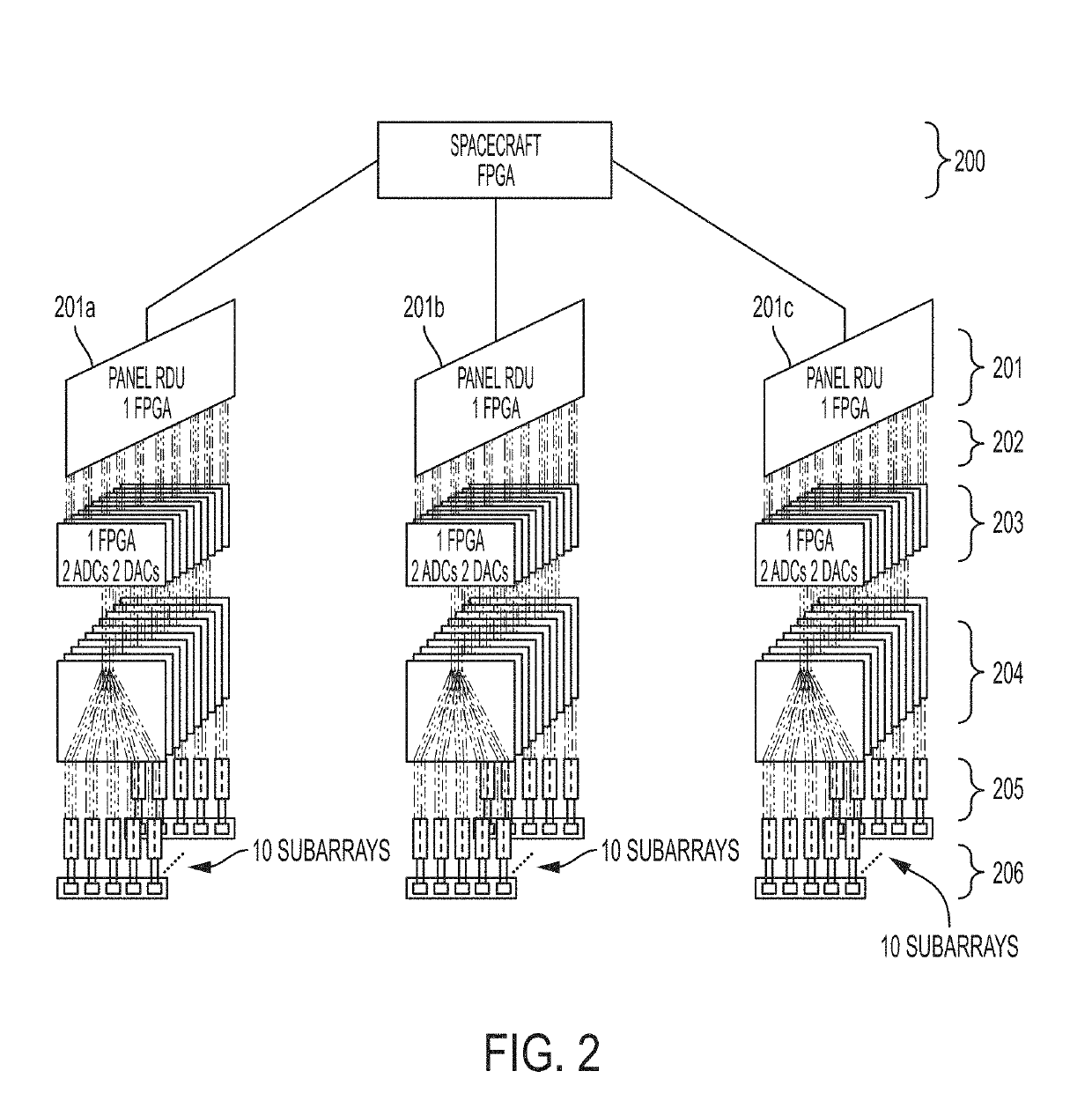
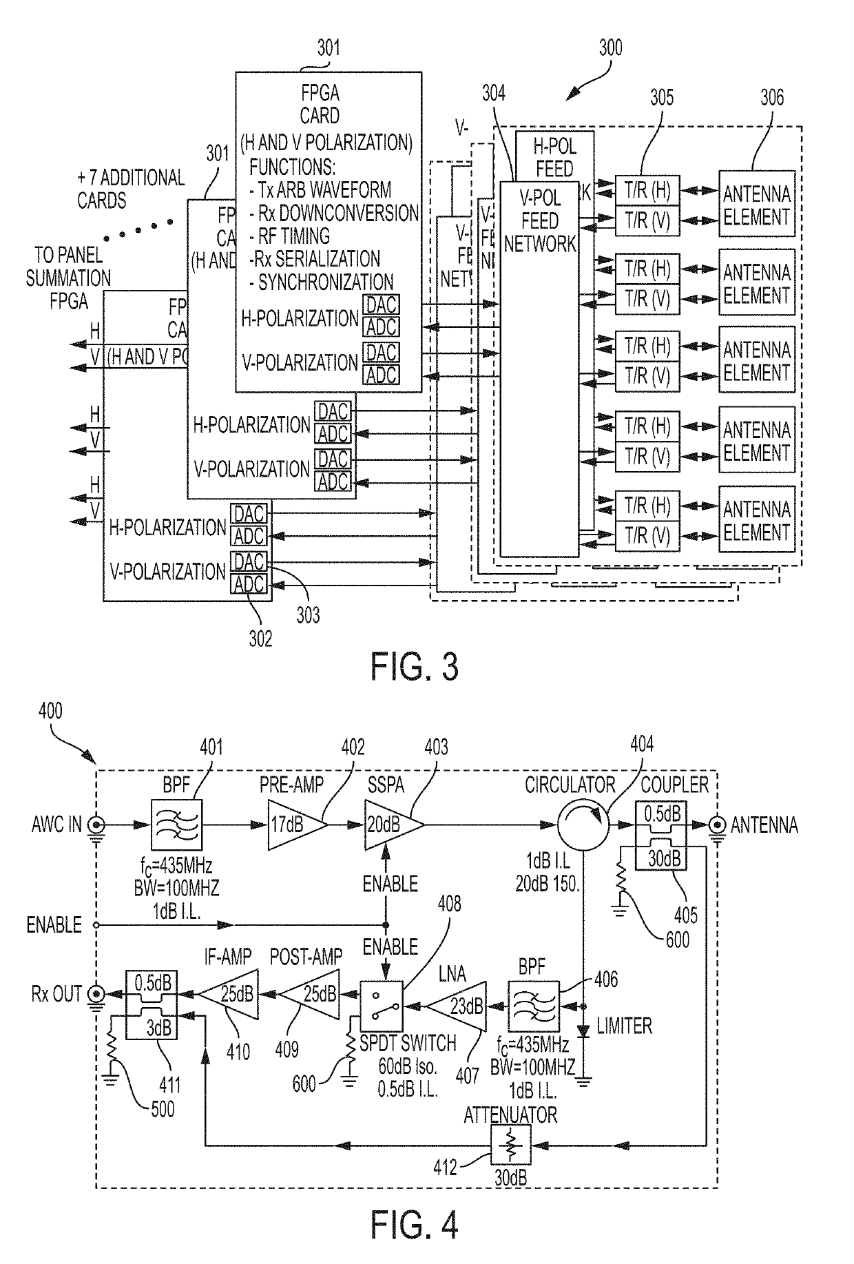
[0043]The present invention relates to an advanced spaceborne Synthetic Aperture Radar (SAR) system and method that can provide high resolution measurements of the Earth or planetary surface, overcoming limitations in conventional SAR systems, and reduce development costs. The present invention enables feasible and affordable spaceborne instruments that meet or exceed science needs by the science and commercial remote sensing community. The architecture of the present invention incorporates advancements in radar technology and techniques making this radar capable of imaging modes not possible with conventional radars.

[0044]The present invention is applicable to a number of science and commercial applications areas including the measurement of ecosystem structure and extent, surface and sub-surface topography, soil freeze-thaw, ice sheet composition and extent, glacier depth, and surface water, among many others.

[0045]The present invention is directed to improving spaceborne SAR syst...


PUM


Abstract

The present invention relates to an advanced spaceborne Synthetic Aperture Radar (SAR) system and method that can provide high resolution measurements of the Earth or planetary surface, overcoming limitations in conventional SAR systems, and reduce development costs. The present invention utilizes advanced and innovative techniques, such as software defined waveforms, digital beamforming (DBF) and reconfigurable hardware, to provide radar capabilities not possible with conventional radar instruments, while reducing the radar development cost. The SAR system architecture employs a modular, low power, lightweight design approach to meet stringent spaceborne radar instrument requirements. Thus, the present invention can enable feasible Earth and planetary missions that address a vast number survey goals, including the measurement of ecosystem structure and extent, surface and sub-surface topography, subsurface stratigraphy, soil freeze-thaw, ice sheet composition and extent, glacier depth, and surface water, among many others.

Description

ORIGIN OF THE INVENTION[0001]The invention described herein was made by an employee of the United States Government, and may be manufactured or used by or for the Government for governmental purposes without the payment of any royalties thereon or therefor.BACKGROUND OF THE INVENTION1. Field of the Invention[0002]The present invention relates to an advanced spaceborne Synthetic Aperture Radar (SAR) system and method, that can provide high resolution measurements of the Earth's or a planetary body's surface, overcoming limitations inherent in conventional SAR systems, and reducing the development cost. The present invention is applicable to a number of science and commercial applications areas including the measurement of ecosystem structure and extent, surface and sub-surface topography, soil freeze-thaw, ice sheet composition and extent, glacier depth, and surface water, among many others.2. Description of the Related Art[0003]Synthetic-aperture radar (SAR) is a type of radar which...

Claims


Application Information

Patent Timeline
Patent Type & Authority Applications(United States)
IPC IPC(8): G01S13/90
CPCG01S13/9035G01S2013/9047G01S7/032G01S13/90G01S13/9023G01S13/904G01S13/9076H01Q1/288H01Q9/0414H01Q21/0025H01Q21/065H01Q23/00H01Q25/00G01S13/9047
Inventor RINCON, RAFAEL F.RANSON, KENNETH J.FATOYINBO AGUEH, TEMILOLA E.CARTER, LYNN M.
Owner NASA
Why Eureka
Try Eureka