

Method for using GPS and crosslink signals to correct ionospheric errors in space navigation solutions
a technology of space navigation and crosslink signal, applied in the field of satellite communication and navigation, can solve problems such as errors in range and range rate estimates, system design and implementation complexity, and infancy of systems
- Summary
- Abstract
- Description
- Claims
- Application Information
AI Technical Summary
Benefits of technology
Problems solved by technology
Method used
Image

Examples
first embodiment
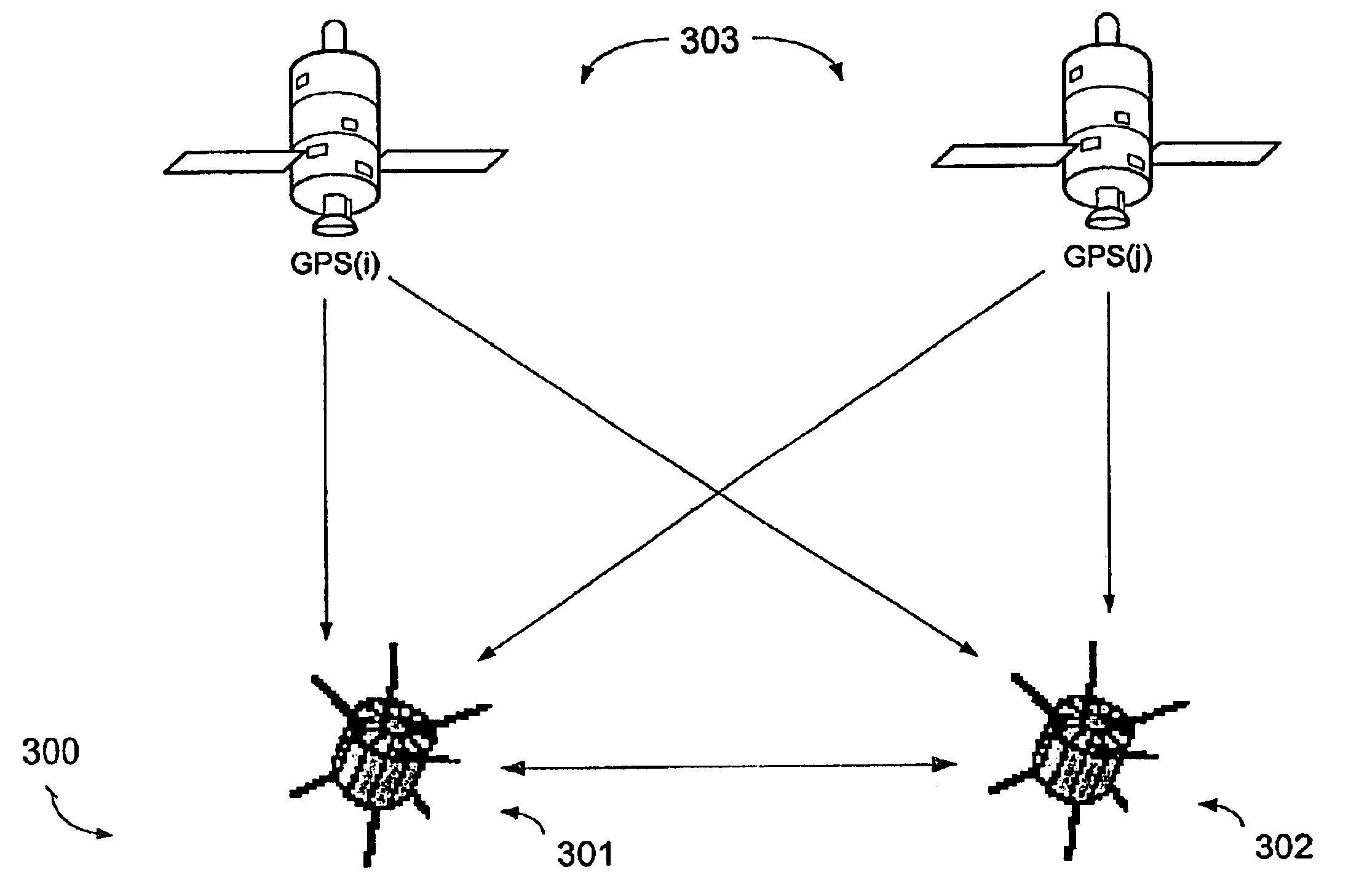
FIG. 4 is a flow chart illustrating a method of utilizing GPS and crosslink signals in distributed spacecraft systems to correct for ionospheric errors using pseudorange measurements according to the present invention. In step 401, spacecraft 301 receives a single frequency GPS measurement set from the GPS system 303. At the same time, in step 402, spacecraft 302 receives a single frequency GPS measurement set from the GPS system 303. Spacecraft 301 and 302 then exchange GPS measurements to compute a differential (relative range) solution (i.e., the relative navigation solution vector) and to measure a relative range between spacecraft 301 and 302 using the crosslink signal (i.e., the scalar crosslink range), in step 403. In step 404, the true scaled relative displacement of spacecraft 301 and 302 is estimated using Equation 1 and a norm of the relative navigation solution vector and the scalar crosslink range determined in steps 401-403. In step 405, a compensated relative range so...
second embodiment
FIG. 5 is a flow chart illustrating a method of utilizing GPS and crosslink signals in distributed spacecraft systems to correct for ionospheric errors using carrier phase measurements according to the present invention. In step 501, spacecraft 301 receives a single frequency GPS measurement set from the GPS system 303. At the same time, in step 502, spacecraft 302 receives a single frequency GPS measurement set from the GPS system 303. Spacecraft 301 and 302 then exchange GPS measurement sets to compute a differential (relative range) solution (i.e., an integer resolved relative navigation solution vector) and to measure an integer resolved relative range between spacecraft 301 and 302 using the integer resolved crosslink signal (i.e., the integer resolved scalar crosslink range), in step 503. In step 504, the true scaled relative displacement of spacecraft 301 and 302 is estimated using Equation 3 and a norm of the integer resolved relative navigation solution vector and the integ...
PUM
 Abstract
Description
Claims
Application Information