GPS correction methods, apparatus and signals

a technology of gps correction and apparatus, applied in traffic control systems, navigation instruments, instruments, etc., can solve problems such as errors, limitations in position determination, and variations in errors in gps position fixing

Inactive Publication Date: 2005-03-01
TRIMBLE NAVIGATION LTD
View PDF60 Cites 76 Cited by
  • Summary
  • Abstract
  • Description
  • Claims
  • Application Information

AI Technical Summary

Benefits of technology

Methods and apparatus are described and illustrated for producing GPS corrections, comprising: collecting measurements from a plurality of network reference stations; determining network corrections from the measurements; determining residual errors at one or more vernier-cell reference stations; and preparing vernier-cell corrections to compensate the residual errors within a vernier-cell region.

Problems solved by technology

Use of the global positioning system (GPS) to determine position has become commonplace, though the position determination has limitations.
A GPS position fix can have an error which arises from a variety of unintended sources and, until recently, from the effect of Selective Availability.
These errors can vary over time and with location.
A limitation of the VRS technique and of WAAS is that the differential correction signals, while valid over a wide area, are still not sufficiently accurate for some purposes.

Method used


Image

  • GPS correction methods, apparatus and signals
  • GPS correction methods, apparatus and signals
  • GPS correction methods, apparatus and signals

Examples


Embodiment Construction

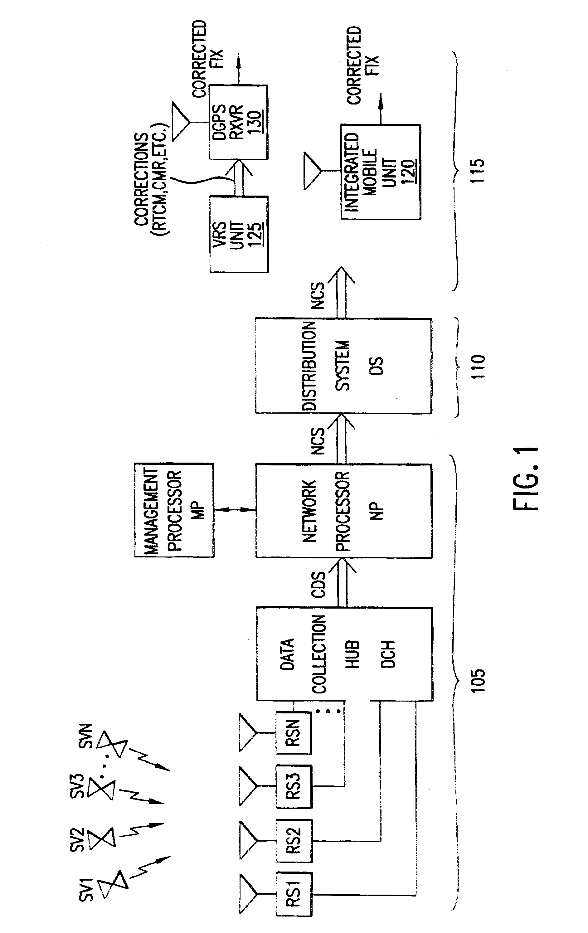
FIG. 1 is a schematic diagram of a system 100 for providing differential correction signals and corrected position fixes in accordance with preferred embodiments of the invention. The system has three major subsystems: (1) infrastructure 105 for generation of correction data from GPS satellite signals, (2) a distribution system 110 of delivery media for real-time distribution of correction data to mobile equipment, and (3) mobile equipment 115.

Infrastructure subsystem 105 comprises a number of reference stations RS1, RS2, RS3, . . . , RSN, a data collection hub DCH, data-transmission channels DT1, DT2, DT3, . . . , DTN communicating data from the reference stations to the data collection hub, and a network processor NP.

The reference stations are preferably geodetic-quality L1 / L2 GPS receivers located at sites around the perimeter, at a minimum, of a region of interest. This area can range in size from a small town to worldwide. For example, eight reference station sites might be dep...


PUM


Abstract

Methods and apparatus are described and illustrated for producing GPS corrections, comprising: collecting measurements from a plurality of network reference stations; determining network corrections from the measurements; determining residual errors at one or more vernier-cell reference stations; and preparing vernier-cell corrections to compensate the residual errors within a vernier-cell region. Network correction streams are described and illustrated which contain network corrections derived from a plurality of network reference stations and residual error corrections derived from one or more vernier-cell reference stations. Methods and apparatus are described for employing such network correction streams in a virtual reference station to produce corrections and/or virtual measurements for use in a GPS receiver.

Description

BACKGROUND OF THE INVENTION1. Field of the InventionThe invention relates to global positioning system methods, apparatus and signals, particularly employing corrections enabling performance suitable for code-phase-differential and real-time-kinematic applications.2. Prior ArtUse of the global positioning system (GPS) to determine position has become commonplace, though the position determination has limitations. A GPS position fix can have an error which arises from a variety of unintended sources and, until recently, from the effect of Selective Availability. These errors can vary over time and with location. Various techniques have been developed to reduce the errors.One approach is basic Differential GPS (DGPS), in which a fixed reference station at a known location generates corrections for all satellites in view. The corrections are transmitted to a roving GPS receiver, where they are used to remove common-mode errors, i.e., errors common to the reference station and the rovin...

Claims


Application Information

Patent Timeline
Patent Type & Authority Patents(United States)
IPC IPC(8): G01S5/00G01S5/14G01S19/32G01S19/44
CPCG01S5/009G01S19/07G01S19/04G01S19/072G01S19/071
Inventor ROBBINS, JAMES E.
Owner TRIMBLE NAVIGATION LTD
Why Eureka
Try Eureka