Systems and methods for knowledge discovery in spatial data

a knowledge discovery and spatial data technology, applied in the field of systems and methods for knowledge discovery in spatial data, can solve the problems of reducing the accuracy of prediction methods, increasing the time-consuming task of implementing such algorithms from scratch, and inability to fully extract knowledge from high-dimensional data in large spatial databases. the effect of noise in data

Inactive Publication Date: 2005-03-08
BATTELLE ENERGY ALLIANCE LLC
View PDF14 Cites 82 Cited by
  • Summary
  • Abstract
  • Description
  • Claims
  • Application Information

AI Technical Summary

Benefits of technology

The spatial data is analyzed through the spatial data analysis and modeling module, which includes a number of different modules, all of which may or may not be implemented when analyzing a particular set of spatial data. The loading module assists the user in loading or generating spatial data. The loading module also performs basic data partitioning. The inspection module provides basic statistical information such as scatterplots, histograms, QQ plots, and 2-D and 3-D surface plots. The inspection module also provides variograms and correlograms. The preprocessing module cleans up and eliminates noise in the data. The preprocessing module also allows the user to normalize and discretize the data. The user can also select or extract the most relevant attributes or generate new attributes through the preprocessing module. The partitioning module allows for more complex partitioning schemes to be used with the spatial data in order to find more homogeneous data portions. The prediction module assists the user in applying classification techniques and regression techniques in order to predict real valued variables. The integration module improves prediction methods through different integration and combining schemes provided by the present invention. Finally, the recommendation module provides the user with recommendations as to how to achieve a desired target value.
The spatial data analysis and modeling module is not limited to any particular set of spatial data mining algorithms but is flexible to adapt to newly developed algorithms and allows the user to create new prediction methods. The present invention allows for algorithms created in a number of different programming environments to be useful in a single system through unified control. Those skilled in the art will recognize that the present invention is a valuable tool which enables a user to evaluate past and present data from various sites in order to create history-based recommendations for that particular site.

Problems solved by technology

Furthermore, as algorithms become more complex, and as hybrid algorithms combining several approaches are suggested, the task of implementing such algorithms from scratch becomes increasingly time consuming.
Current data mining techniques are unable to fully extract knowledge from high dimensional data in large spatial databases, while data analysis in typical knowledge discovery software is limited to non-spatial data.
It is also known that there is no universally best data mining algorithm across all application domains.
However, no GIS system with significant spatial data mining functionality is currently available.
However, methodologies to efficiently interpret the meaning of these large and multi-featured data sets are lacking.
Furthermore, precision agriculture data is inherently distributed at multiple farms and cannot be localized on any one machine for a variety of practical reasons including physically dispersed data sets over many different geographic locations, security services and competitive reasons.

Method used


Image

  • Systems and methods for knowledge discovery in spatial data
  • Systems and methods for knowledge discovery in spatial data
  • Systems and methods for knowledge discovery in spatial data

Examples


Embodiment Construction

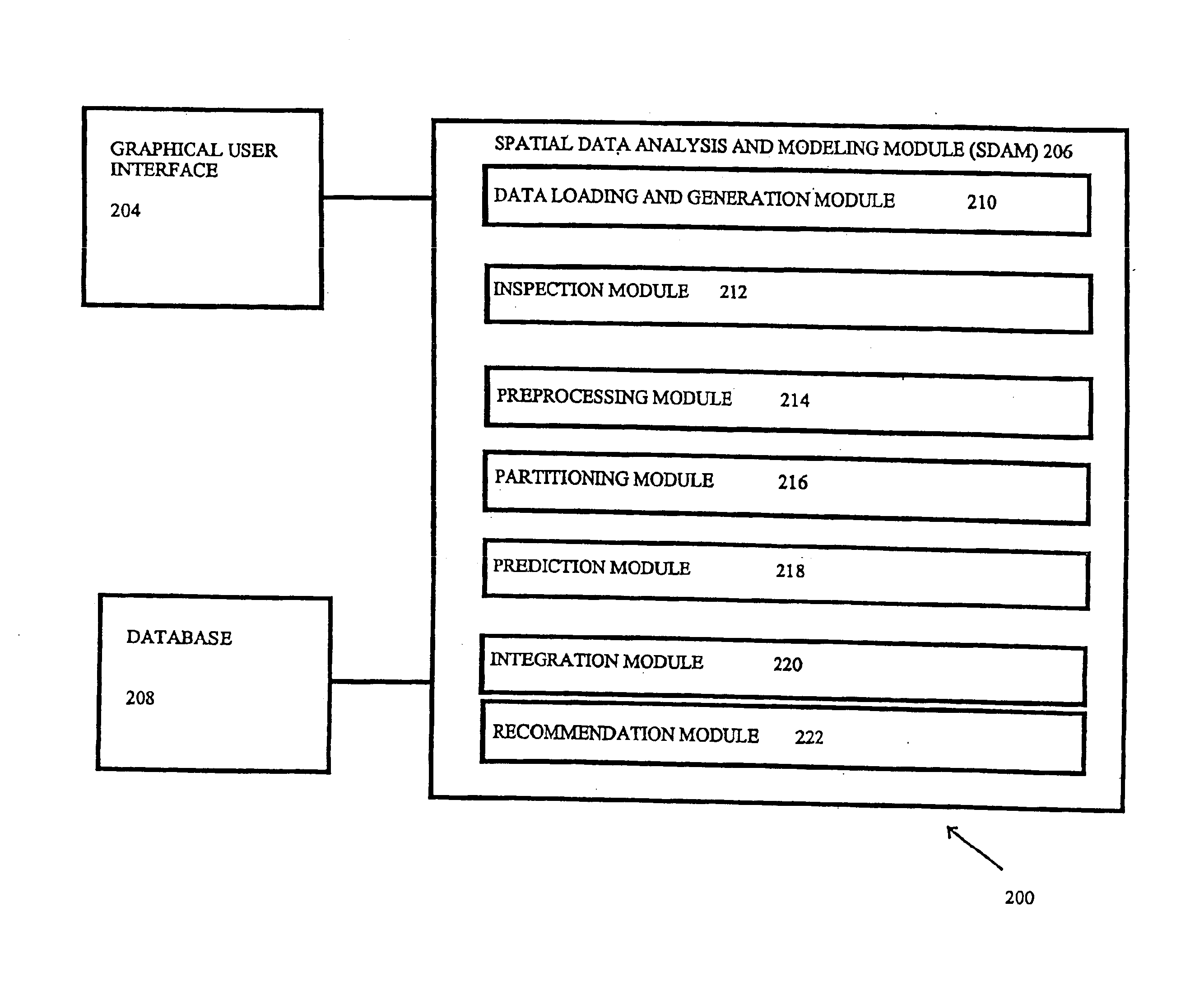
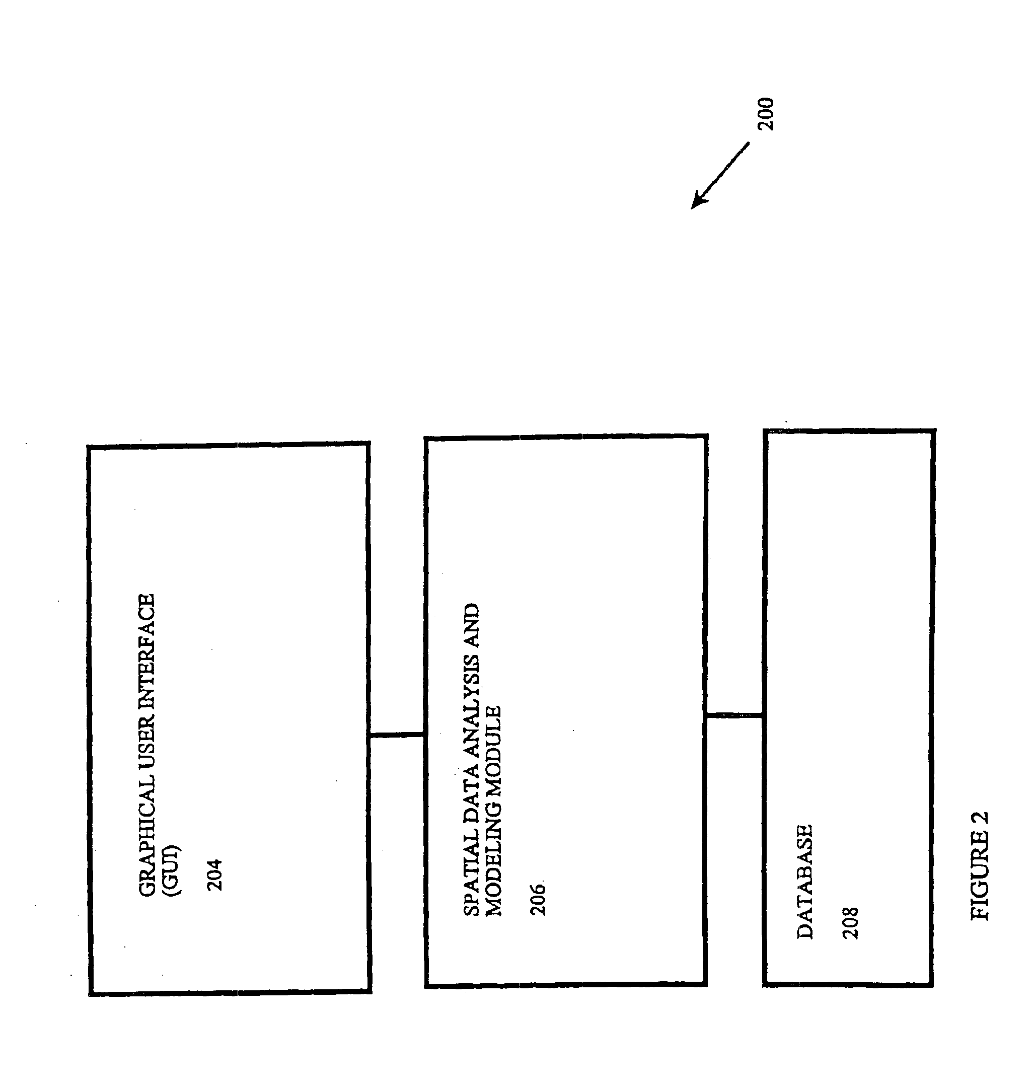
The present invention relates to knowledge discovery in spatial data and more particularly to systems and methods for analyzing and extracting useful information from the spatial data. Analyzing and modeling spatial data in accordance uses the following modules: a data generation and manipulation module; a data inspection module; a data preprocessing module; a data partitioning module; a modeling module; and a model integration module. In some embodiments of the present invention, not all of the modules are used to successfully analyze and model the spatial data.

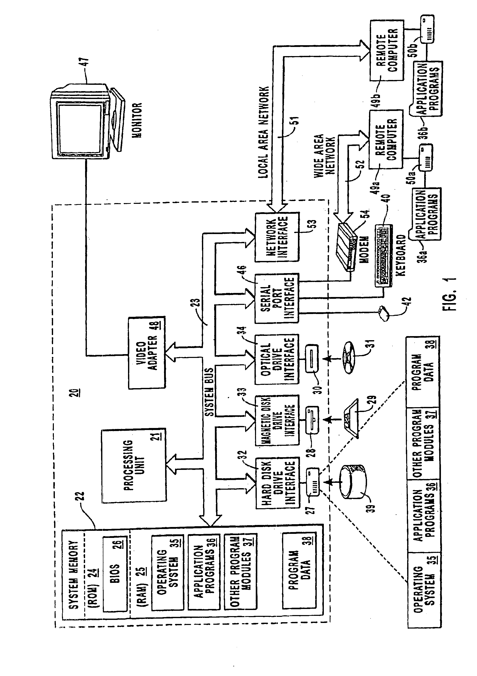
The embodiments of the present invention may comprise a special purpose or general purpose computer including various computer hardware, as discussed in greater detail below. Embodiments within the scope of the present invention also include computer-readable media for carrying or having computer-executable instructions or data structures stored thereon. Such computer-readable media can be any available media which can be ac...


PUM


Abstract

Systems and methods are provided for knowledge discovery in spatial data as well as to systems and methods for optimizing recipes used in spatial environments such as may be found in precision agriculture. A spatial data analysis and modeling module is provided which allows users to interactively and flexibly analyze and mine spatial data. The spatial data analysis and modeling module applies spatial data mining algorithms through a number of steps. The data loading and generation module obtains or generates spatial data and allows for basic partitioning. The inspection module provides basic statistical analysis. The preprocessing module smoothes and cleans the data and allows for basic manipulation of the data. The partitioning module provides for more advanced data partitioning. The prediction module applies regression and classification algorithms on the spatial data. The integration module enhances prediction methods by combining and integrating models. The recommendation module provides the user with site-specific recommendations as to how to optimize a recipe for a spatial environment such as a fertilizer recipe for an agricultural field.

Description

FIELD OF THE INVENTIONThe present invention relates to systems and methods for knowledge discovery in spatial data. More particularly, the present invention relates to systems and methods for mining data from a spatial database and more specifically to optimizing a recipe for a spatial environment by extracting knowledge from a spatial database.PRIOR STATE OF THE ARTIn recent years, the contemporary data mining community has developed a plethora of algorithms and methods used for different tasks in knowledge discovery within large databases. Few of the algorithms and methods are publicly available and a researcher who wishes to compare a new algorithm with existing algorithms, or analyze real data, finds the task daunting. Furthermore, as algorithms become more complex, and as hybrid algorithms combining several approaches are suggested, the task of implementing such algorithms from scratch becomes increasingly time consuming.Current data mining techniques are unable to fully extrac...

Claims


Application Information

Patent Timeline
Patent Type & Authority Patents(United States)
IPC IPC(8): G06F7/00G06K9/62
CPCG06K9/6253Y10S707/99948Y10S707/99945Y02A40/10G06F18/40
Inventor OBRADOVIC, ZORANFIEZ, TIMOTHY E.VUCETIC, SLOBODANLAZAREVIC, ALEKSANDARPOKRAJAC, DRAGOLJUBHOSKINSON, REED L.
Owner BATTELLE ENERGY ALLIANCE LLC
Why Eureka
Try Eureka