Avionics system and method for providing altitude alerts during final landing approach

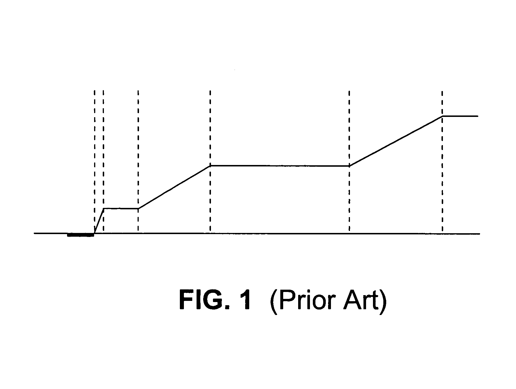
a technology of altitude alert and final landing, which is applied in the direction of process and machine control, instruments, and navigation instruments, can solve the problems of flight level system, terrain alert system, and conventionally provided fixed altitude flight level or fixed terrain clearance level for fixed radial distances from runway, etc., to reduce nuisance alerts, increase reliability, and increase safety

Active Publication Date: 2005-12-27
GARMIN INT
View PDF44 Cites 76 Cited by
  • Summary
  • Abstract
  • Description
  • Claims
  • Application Information

AI Technical Summary

Benefits of technology

[0015]Particular advantages of the present invention are found in increased safety through an increase in reliable data used in calculating specific FAFSA values for each runway and approach. Additional safety enhancements are achieved through fewer nuisance alerts being issued to pilots during the crucial final approach phase of landing an aircraft. By selection of a FAFSA pattern in the final section that is different from that used in prior sections, actual pilot landing techniques are taken into consideration to further reduce nuisance alerts and increase safety.

Problems solved by technology

Conventional Premature Descent Alert systems that provide fixed altitude flight levels or fixed terrain clearance levels for fixed radial distances from the runway regardless of the runway or approach to the runway are insufficient in that they are not conducive to every runway and approach.
One particular example that may cause particular problems for a fixed altitude flight level system is where a particular runway is nestled in a valley or has a large tower near it.
In some systems, however, the terrain alert systems are desensitized to reduce nuisance alerts during landing.
This may delay crucial safety warnings and alerts that could otherwise be provided.
Another particular example that may cause problems for a fixed clearance flight level system is where the runway is raised significantly above the surrounding terrain such as on a mountain, a mesa, or a cliff.
While the fixed clearance levels referenced may have allowed the aircraft to receive necessary alerts in relation to the previous example, the fixed clearance levels may have problems with this example.
In this case also, if the terrain alert systems are desensitized, crucial safety warnings and alerts may be further delayed until a smooth correction is no longer possible.
As a result, conventional systems do not compensate for actual aircraft approach flight paths, runway environment, or airport obstacles, but rather focus only on flight safety altitudes for given radial distances from the runway.
This may result in excessive nuisance alerts or added risk of collision with terrain or a structure during final approach because the flight safety altitudes selected as the general rule may not be conducive to a particular approach to a specific runway.

Method used


Image

  • Avionics system and method for providing altitude alerts during final landing approach
  • Avionics system and method for providing altitude alerts during final landing approach
  • Avionics system and method for providing altitude alerts during final landing approach

Examples


example 1

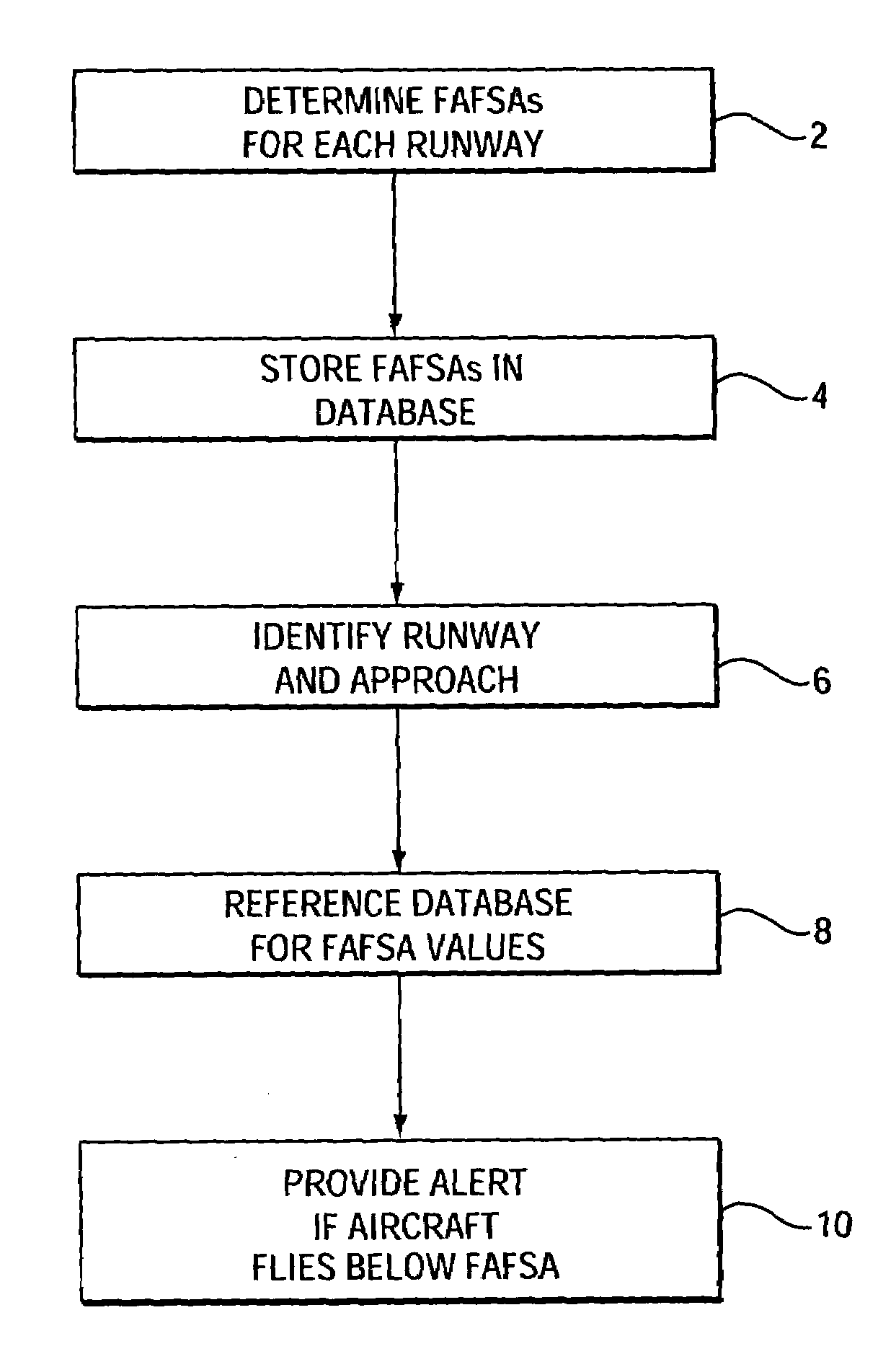
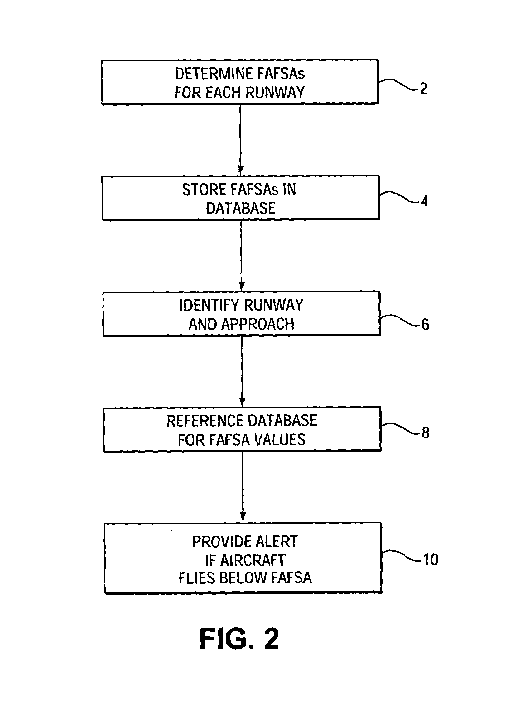
[0026]For a particular runway specific to the present example, there are two possible approach patterns, one from the East and one from the West. The runway is situated at the edge of a high cliff (500 feet above the ocean to the East) and is 3.5 miles from a high mountain to the West (elevation 2000 feet above ocean). In determining FAFSA values for the runway, two sets of data are created, one for the approach from the East and one for the approach from the West. For the example, assume the elevation of both ends of the runway is the same (500 feet).

[0027]The following FAFSA for a particular aircraft and the approach from the West was calculated and determined: between 4 to 5 NM=3900 feet above ocean; between 3 to 4 NM=3250 feet; between 2 to 3 NM=2200 feet; and the FAFSA slopes down from 2200 feet to the start of the runway. Additionally, a transition slope for the FAFSA was used between each distance segment. The Required Obstacle Clearance value for the approach phase of flight...


PUM


Abstract

An avionics system and method is employed for alerting pilots of low premature descent during final landing approach. The method involves determining Final Approach Flight Safety Altitudes for a plurality of runways, identifying which runway an aircraft is likely to land on, and alerting the pilot if the aircraft altitude is lower than the final approach flight safety altitude. The method takes into account terrain information, airport and runway information, and aircraft reference data to make its determination. Particular embodiments reference the Final Approach Fix, one or more step down fix values, the Minimum Descent Altitude and the Missed Approach Point in calculating the Final Approach Flight Safety Altitudes. The system and method have particular utility with a Terrain Awareness and Warning System (“TAWS”) and display in an aircraft.

Description

BACKGROUND OF THE INVENTION[0001]1. Technical Field[0002]The present invention relates generally to determining appropriate aircraft safety clearance altitudes during the final approach of the aircraft to a runway, and more particularly to determining safety clearance altitudes for an aircraft between a Final Approach Fix (“FAF”) point and one or more step-down points located between the FAF and the runway.[0003]2. Background Art[0004]Systems are known in the art that provide alerts and advisory indications of premature descent. Among such systems are systems that monitor parameters of the aircraft's flight, particularly the aircraft's current position and flight path information, and a terrain elevation database.[0005]Satellite-based navigational systems, such as Global Positioning System (“GPS”), which can track longitude, latitude, altitude, groundtrack, vertical velocity and ground speed, are becoming an important and reliable source of information for aircraft. An aircraft's Fo...

Claims


Application Information

Patent Timeline
Patent Type & Authority Patents(United States)
IPC IPC(8): G01C21/00G01C23/00G01S1/00G06F7/00
CPCG01C21/005G01C23/00G05D1/0676G08G5/025G01S19/15
Inventor CHEN, SUSAN S.BARBER, CLAYTON E.
Owner GARMIN INT
Why Eureka
Try Eureka