Encoding and compression of a location beacon database

a technology of location beacons and database, applied in the field of location-based services, can solve the problems of suboptimal approaches, substantial errors, confusion of receivers, etc., and achieve the effect of facilitating storage and/or transmission of database contents

Active Publication Date: 2009-03-10
SKYHOOK WIRELESS
View PDF49 Cites 239 Cited by
  • Summary
  • Abstract
  • Description
  • Claims
  • Application Information

AI Technical Summary

Problems solved by technology

Each of these approaches has its strengths and weaknesses based on the radio technology and the positioning techniques they employ.
Weather, buildings or structures and foliage can cause interference because the receivers require a clear line-of-sight to three or more satellites.
The radio signals from the satellites bounce off physical structures causing multiple signals from the same satellite to reach a receiver at different times. Since the receiver's calculation is based on the time the signal took to reach the receiver, multi-path signals confuse the receiver and cause substantial errors.
Unfortunately these approaches have proven to be suboptimal due to the heterogeneous nature of the cellular tower hardware along with the issues of multi-path signals and the lack of uniformity in the positioning of cellular towers.
These systems have been plagued by slow response times and poor accuracy—greater than 100 meters in downtown areas.
The challenges facing this model are the cost of the new hardware receiver and the limitations of using such a small set of reference points.
For example, if a user is outside the perimeter of towers, the system has a difficult time providing reasonable accuracy.
Since there are no TV towers out in the ocean, there is no way to provide reference symmetry among the reference points resulting in a calculated positioning well inland of the user.
Because individuals voluntarily supply the data the systems suffer a number of performance and reliability problems.
Third, the user-supplied data suffers from arterial bias.
Because the data is self-reported by individuals who are not following designed scanning routes, the data tends to aggregate around heavy traffic areas.
Arterial bias causes a resulting location pull towards main arteries regardless of where the user is currently located causing substantial accuracy errors.
Fourth, these databases include the calculated position of scanned access points rather than the raw scanning data obtained by the 802.11 hardware.
The accuracy requirements for these use cases are very demanding typically calling for 1-3 meter accuracy.
While these systems are becoming more reliable for these indoor use cases, they are ineffective in any wide-area deployment.
It is impossible to conduct the kind of detailed site survey required across an entire city and there is no way to rely on a constant communication channel with 802.11 access points across an entire metropolitan area to the extent required by these systems.
Most importantly, outdoor radio propagation is fundamentally different than indoor radio propagation rendering these indoor positioning techniques almost useless in a wide-area scenario.

Method used


Image

  • Encoding and compression of a location beacon database
  • Encoding and compression of a location beacon database
  • Encoding and compression of a location beacon database

Examples


Embodiment Construction

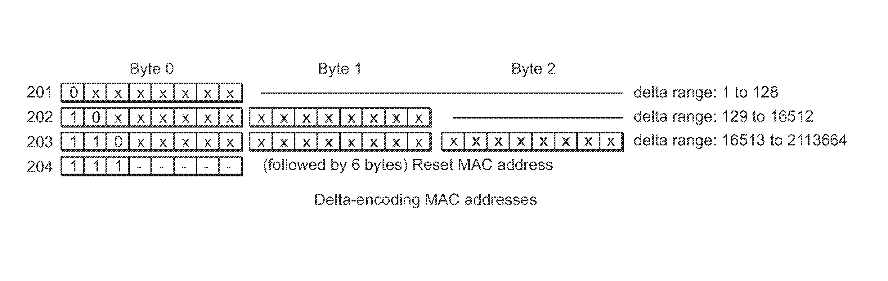
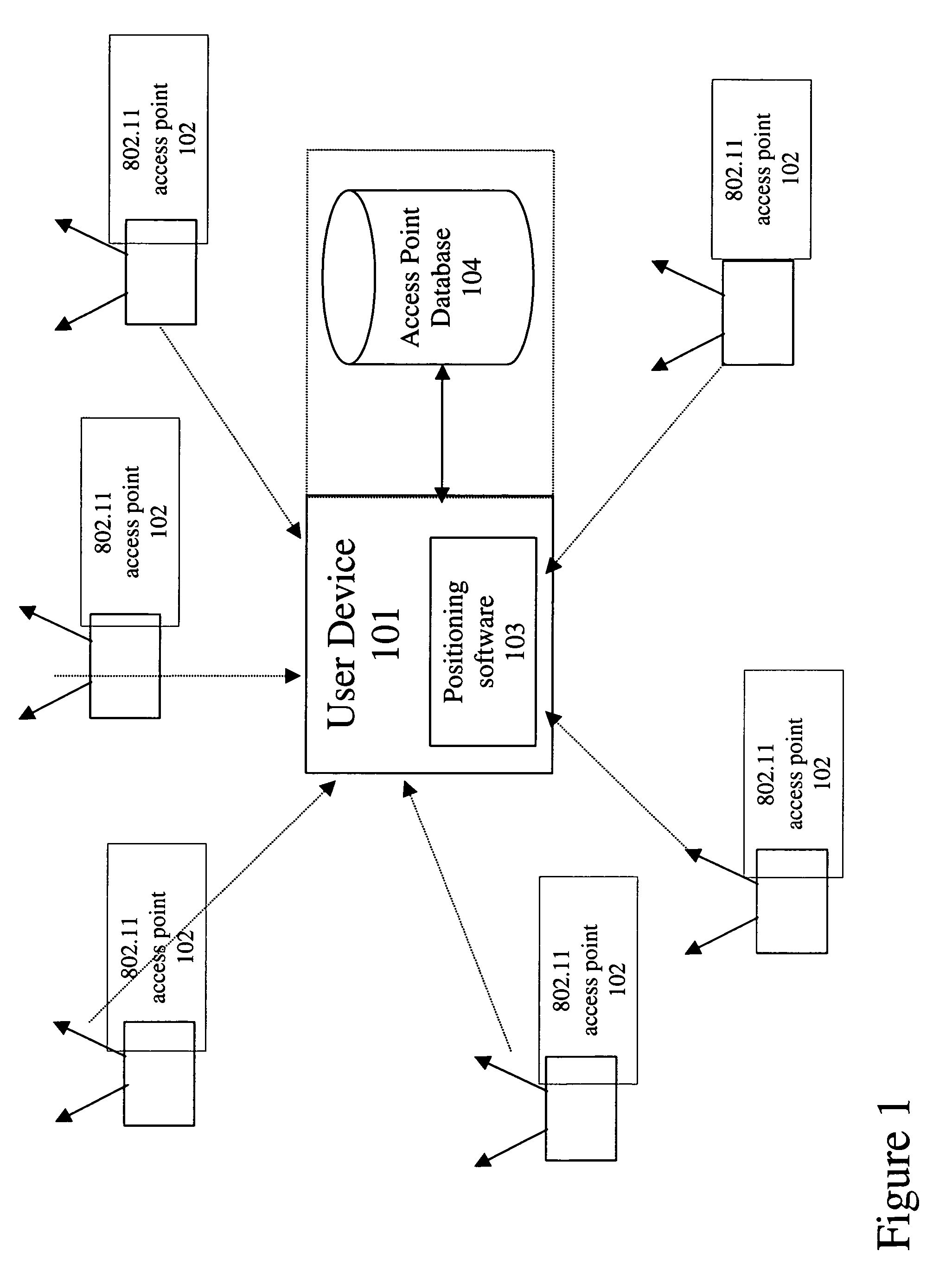
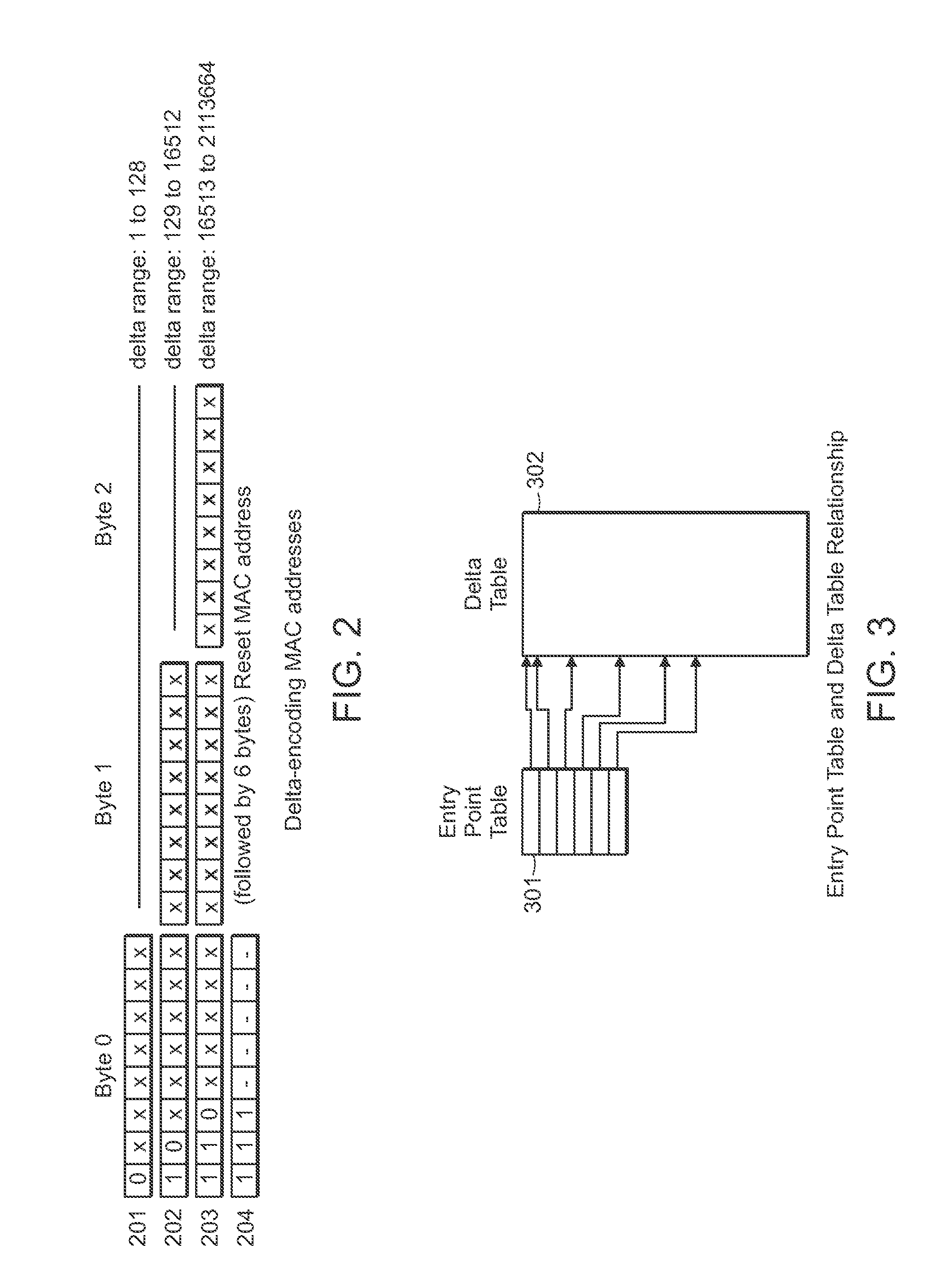
[0038]Embodiments of the present invention provide methods for encoding and compression of a location beacon database, such as a 802.11 Wi-Fi access point database, for use in a Wi-Fi Positioning System. The access point database may contain millions of access points with corresponding locations of the points. This presents a challenge for any device centric model where the database is wirelessly downloaded and kept locally on the mobile device. However, it is desirable to have an access point database on the mobile device. By leveraging the device centric model, users do not require a continuous network connection. Removing the network requirement allows the database to be usable in more application scenarios. Under certain embodiments, a data encoding and compression technique significantly reduces the data storage requirements for the access point database, making it easier to distribute the database or segments of the database to Wi-Fi enabled devices.

[0039]An uncompressed MAC a...


PUM


Abstract

A method of delta-encoding and compressing a table containing 6-byte MAC addresses is provided. The MAC addresses are sorted, a first MAC address is stored, and only the binary differences between succeeding MAC addresses are stored. A method of reading a delta-encoded and compressed MAC address table is provided. A first unencoded MAC address is read. The remaining MAC addresses are generated by successively adding stored binary differences to the result of the previous addition. A method of encoding and compressing a location table is provided. A reference latitude and longitude is selected and stored. The offsets from the reference latitude and longitude are stored for the remaining locations. A method of reading an encoded location table is provided. A stored reference latitude and longitude is read. Stored offsets are read and applied to the reference latitude and longitude to generate a set of latitude and longitude locations.

Description

CROSS-REFERENCE TO RELATED APPLICATIONS[0001]This application claims the benefit under 35 U.S.C. §119(e) of U.S. Provisional Patent Application No. 60 / 658,481, filed on Mar. 4, 2005, entitled Encoding and Compressing the Access Point Database, which is herein incorporated by reference in its entirety.[0002]This application is a continuation-in-part of and claims the benefit under 35 U.S.C. § 120 of co-pending U.S. patent application Ser. No. 11 / 261,848, filed on Oct. 28, 2005, entitled Location Beacon Database, which is herein incorporated by reference in its entirety.[0003]This application is related to the following U.S. patent applications, filed on Feb. 22, 2006:[0004]U.S. patent application Ser. No. 11 / 359154, entitled Continuous Data Optimization of Moved Access Points in Positioning Systems;[0005]U.S. patent application Ser. No. 11 / 359271, entitled Continuous Data Optimization by Filtering and Positioning Systems; and[0006]U.S. patent application Ser. No. 11 / 359144, entitled ...

Claims


Application Information

Patent Timeline
Patent Type & Authority Patents(United States)
IPC IPC(8): H04W24/00
CPCH04L29/12009H04L29/12839H04L61/6022H04W8/26H04L69/04H04W4/02H04W84/10H04W88/08H04L61/00H04L2101/622H04W4/029
Inventor MORGAN, EDWARD JAMESPAYNE, ANDREW C.
Owner SKYHOOK WIRELESS
Why Eureka
Try Eureka