
Route guidance system, mobile terminal, server, program and recording medium

a technology of route guidance and mobile terminal, which is applied in the direction of distance measurement, navigation instruments, instruments, etc., can solve the problems of user hitting other pedestrians or other obstacles, he may miss an appropriate turn, and the user may hit other pedestrians or encounter other obstacles

Active Publication Date: 2009-10-13
NAVITIME JAPAN CO LTD
View PDF17 Cites 26 Cited by
  • Summary
  • Abstract
  • Description
  • Claims
  • Application Information

AI Technical Summary

Benefits of technology

[0013]The present invention has therefore been conceptualized to address the foregoing problems. Thus, the objects of the present invention are, namely: (1) to enable a mobile terminal to recognize guide points; (2) to enable the mobile terminal to notify the user of the distance to a guide point, a direction in which to turn, and the like; and (3) to regulate the amount of data conveyed between the mobile terminal and a server when map data for navigation and the like are transmitted and / or received.
[0091]In addition, the mobile terminal (1) of the second embodiment is capable of recognizing the guide points (X5, X8) by means of the route data transmitted / received which is relatively small in quantity compared with the volume of transmitted / received route data and map data combined to form the route guidance map image. As a result, the quantity of the data to be transmitted / received can be reduced.
[0151]In addition, in the program of the mobile terminal (1) of the fourth embodiment, the mobile terminal (1) can recognize the guide points (X5, X8) by means of the transmission / reception of route data which is relatively small in quantity, in contrast to the case of prior art where the production of a route guidance map image by combining the route data and the map data received involves voluminous data. Accordingly, in the mobile terminal (1) of the fourth embodiment, the quantity of the data to be transmitted / received can be reduced.
[0201]Moreover, the present invention can notify the user of the distance to the guide point and the direction in which to make the turn at the guide point.
[0202]Further, the present invention can control the amount of data transmitted / received between the mobile terminal and the server when the map data for navigation and the like are transmitted / received.

Problems solved by technology

For example, if the route is set to turn at an intersection, the user has to determine in which direction to turn, and may take a wrong direction.
Moreover, when the user walks along a route while constantly looking at the screen of the mobile terminal, the user may hit other pedestrians or encounter other obstacles.
Thus, because the user cannot always check the screen of the mobile terminal, he will likely miss an appropriate turn.
Accordingly, since the mobile terminal itself does not have the route data, the mobile terminal cannot determine the required notifying location (guide point), and is therefore incapable of providing such information.
In particular, when route data is built into multiple unit maps as described in Patent Document 1, if a location for making a turn exists on a unit map which has not been received, it is not possible to know such location for making a turn and the direction thereof until the unit map including such information is received.
It is thus not possible to notify the user of the distance to such location for making a turn, or the direction of the turn to be made.
However, although a map need not be divided into unit maps, and entire map data incorporating a certain route may be transmitted to a mobile terminal which is capable of carrying out route searching, the mobile terminal must be equipped with a storage (memory) device with a large capacity for storing essential data such as map data and time tables of transportation facilities, which would entail additional cost in the production of the mobile terminal.
Further, when a mobile terminal processes route searching, load on the information processing device increases.

Method used


Image

  • Route guidance system, mobile terminal, server, program and recording medium
  • Route guidance system, mobile terminal, server, program and recording medium
  • Route guidance system, mobile terminal, server, program and recording medium

Examples


first embodiment

Function of First Embodiment

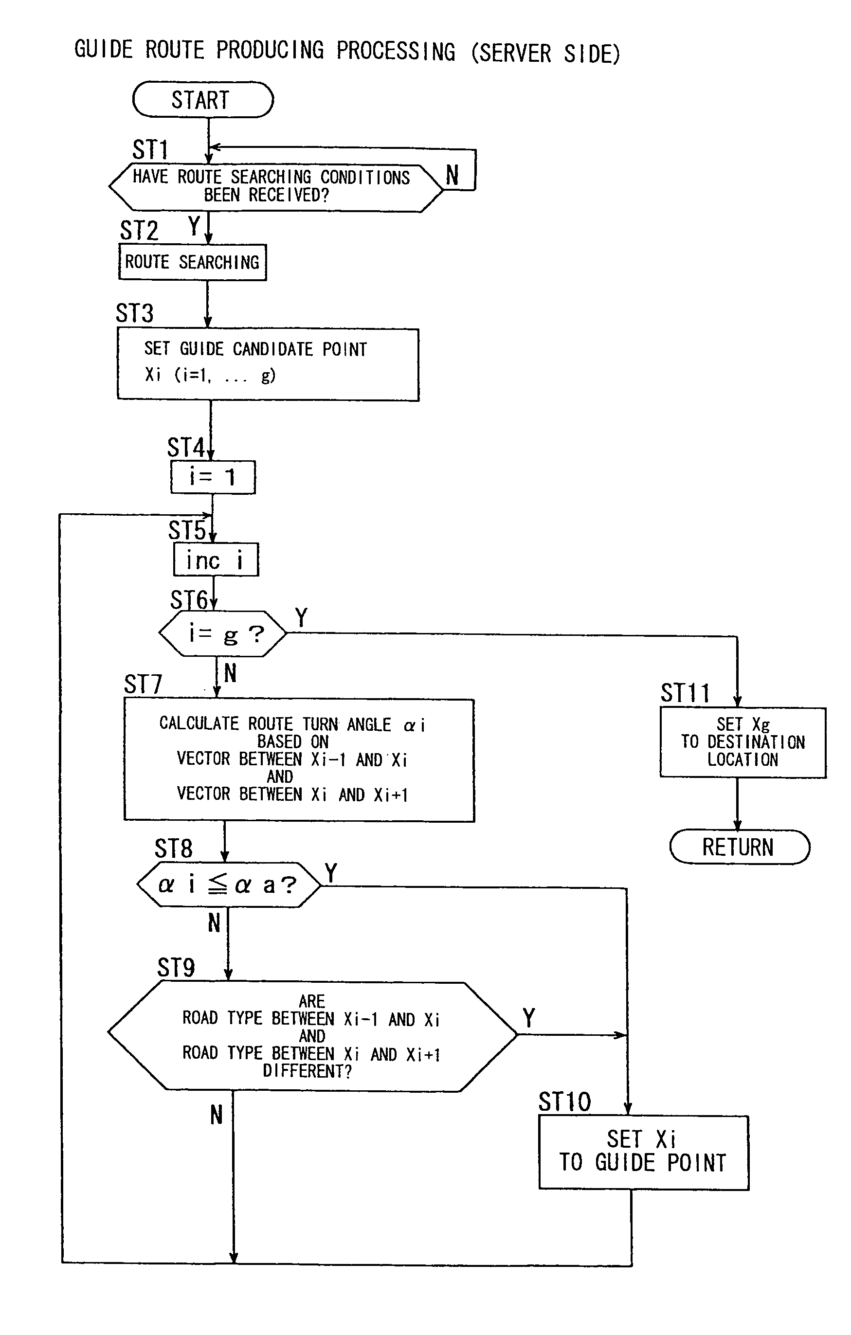
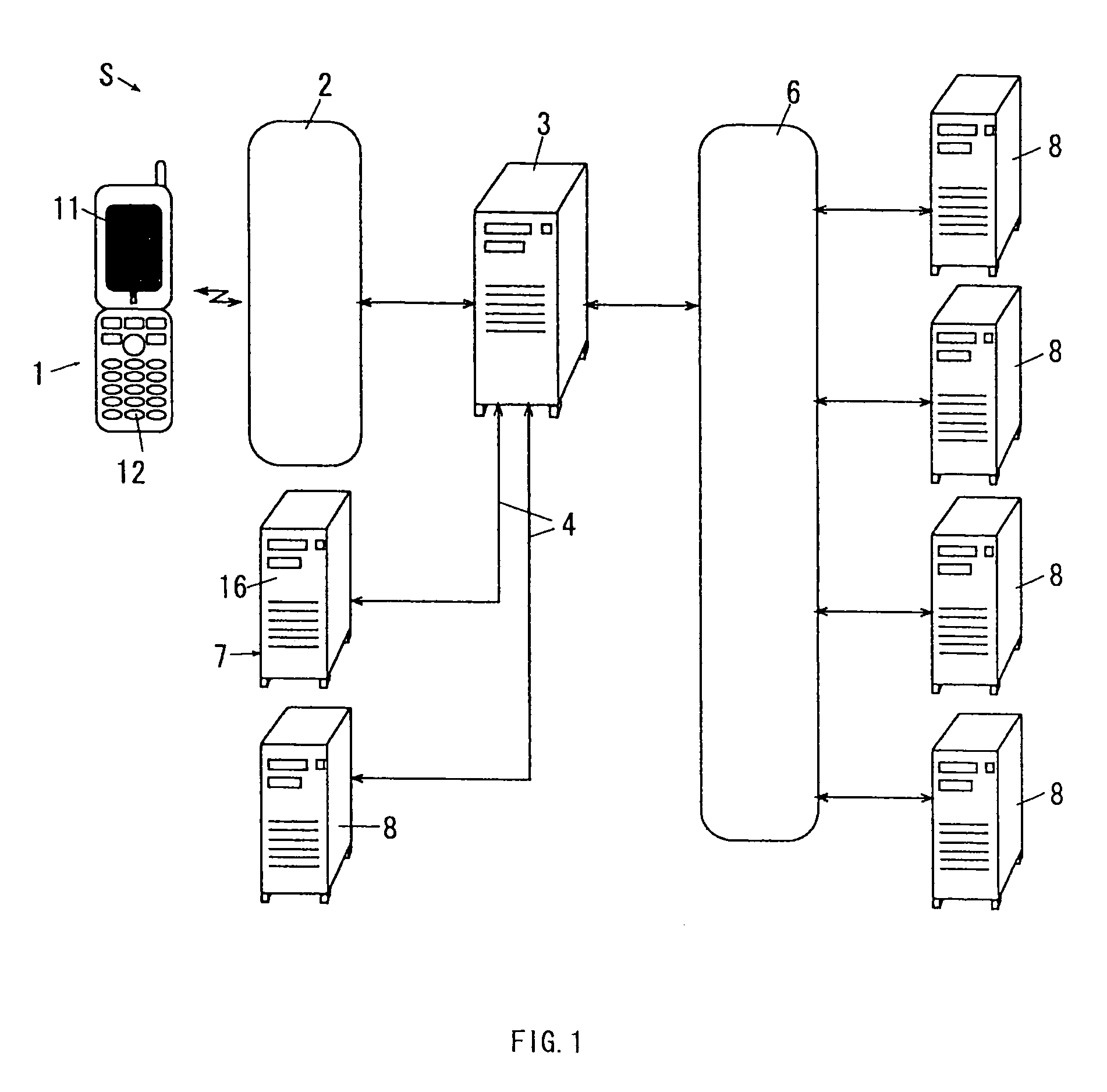
[0413]Under the route guidance system S of the first embodiment provided with the above configuration, a route RX is determined from the starting location X1 to the destination location X10 according to the route searching conditions transmitted from the mobile phone 1, and includes the starting location and the destination location during the route data transmission processing of the server 7 (refer to step ST2). Guide points X5 and X8 are then selected based on predetermined conditions (route turn angle ,,i and the road type data) from among the guide point candidates X1 to X10 comprising the points of connection between the lines and curves of the route RX formed by connecting the multiple lines and curves successively in a guide point setting process (ST3 to ST11). The route data including the guide points X5 and X8 is then produced in the server 7, and transmitted to the mobile phone 1.

[0414]Then, the map data (lacking unit map data) corresponding to...


PUM


Abstract

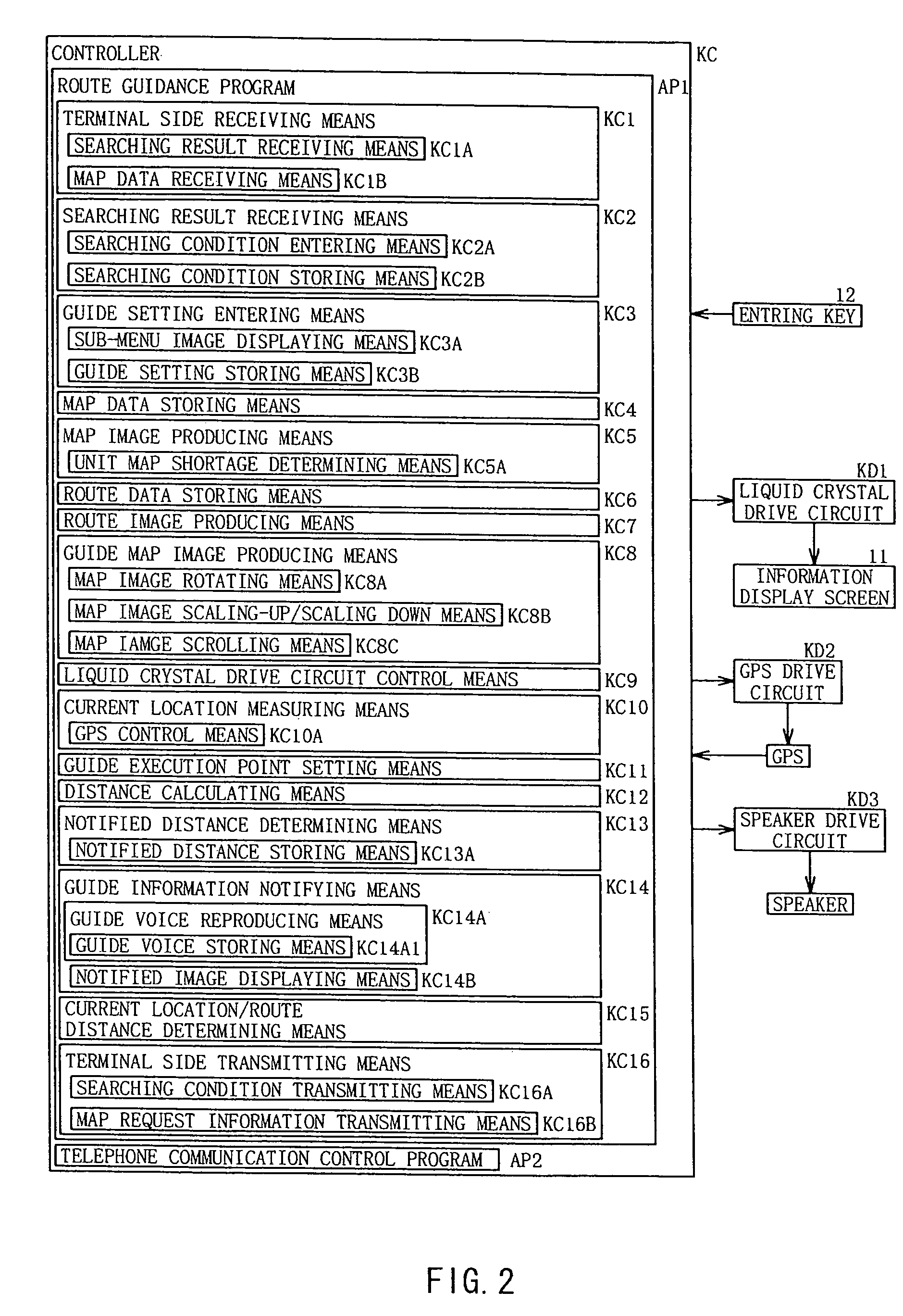
Guide points can be grasped by use of a mobile terminal. The mobile terminal comprises search condition transmitting means (KC16A) for transmitting data of route searching conditions to a server; searching result receiving means (KC1A) for receiving, from the server, route data produced by the server in accordance with the route searching conditions; map request information transmitting means (KC16B) for transmitting, to the server, map data transmission request information for requesting a transmission of map data; map data receiving means (KC1B) for receiving the map data transmitted from the server; route image producing means (KC7) for producing a route image based on a range in which to display on the information display screen (11) and based on the route data; and guide map image producing means (KC8) for producing a route guidance map image by combining, based on the map data, a map image and the route image.

Description

BACKGROUND OF THE INVENTION[0001]1. Field of the Invention[0002]The present invention relates to a mobile terminal provided with an information display screen which can display a route image showing a route from a starting location to a destination location specified by a user, a server which can transmit / receive data to / from the mobile terminal, and can produce a route according to the user's specification, a route guidance system which is provided with the mobile terminal and the server, programs which are used by the mobile terminal and the server, and a recording medium which records the programs.[0003]The present invention more particularly relates to a mobile terminal such as a mobile phone and a PDA (Personal Digital Assistant) which can provide the user with a guidance route based on the user's current location and route data, a server which can transmit / receive data to / from the mobile terminal, a route guidance system which is provided with the mobile terminal and the serve...

Claims


Application Information

Patent Timeline
Patent Type & Authority Patents(United States)
IPC IPC(8): G01C21/00G08G1/0968G09B29/00G01C21/36G08G1/005G09B29/10
CPCG01C21/3629G01C21/3667G01C21/3632
Inventor SUZUKI, YUSUKEKIKUCHI, SHINONISHI, KEISUKE
Owner NAVITIME JAPAN CO LTD
Learn More