
Digital image edge detection and road network tracking method and system

a digital image and edge detection technology, applied in image enhancement, distance measurement, instruments, etc., can solve the problems of inability to handle multi-spectral images, prior art methods of doing this not handling multi-spectral images, and high complexity of segmentation-based operations, so as to reduce road path estimation errors and maximize the joint probability of parameters

Active Publication Date: 2009-12-22
RAYTHEON CO
View PDF6 Cites 44 Cited by
  • Summary
  • Abstract
  • Description
  • Claims
  • Application Information

AI Technical Summary

Benefits of technology

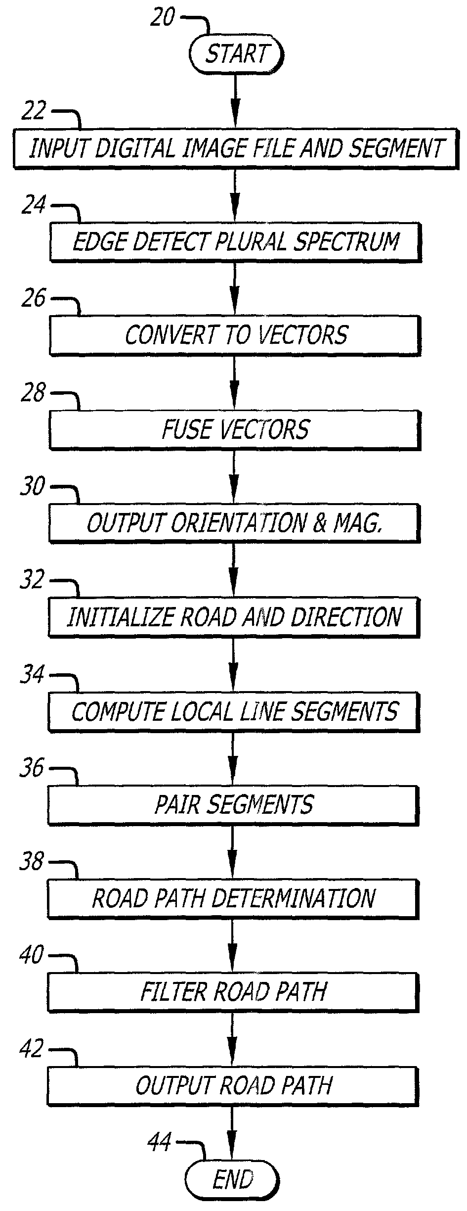
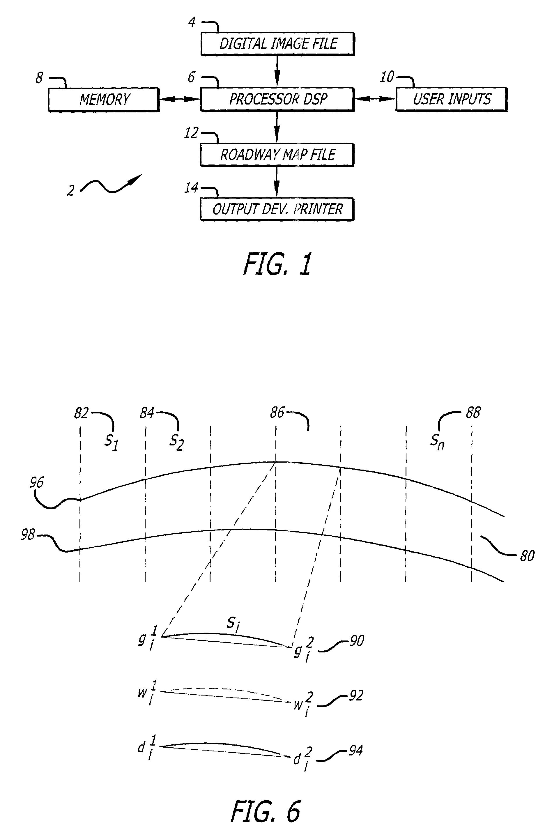
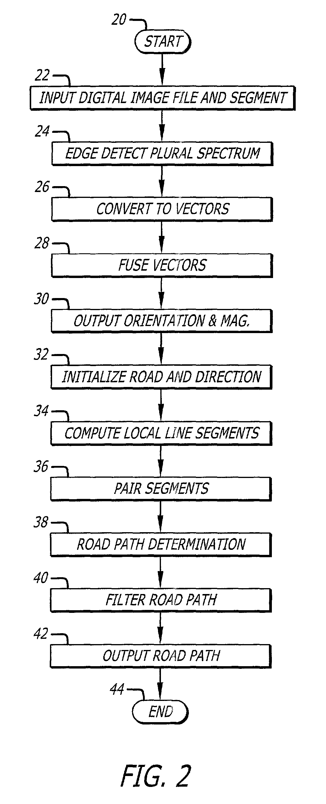
The present invention provides a system and method for extracting road paths from images using edge orientation estimates. The system receives a plurality of edge orientation estimates and transforms a portion of the estimates to improve accuracy. The transformed portion is then aggregated to define road segments. The image is segmented into windows, and the system identifies road segments with parameters such as width, orientation, intensity, or color. A stochastic process is performed on the parameters to identify the road segment with the highest correlation. The system also connects the road segments to create a road path. The invention can be used with color or multi-spectral images and employs directional filters, compass filters, or finite impulse response filters. The transformation process converts scalar edge orientation and magnitude values to vectors, and the aggregation process fuses the transformed portions of the edge estimates using linear operations. The system can also reduce errors by using a non-linear filter.

Problems solved by technology

Orientation estimates obtained by using compass type directional filters are inherently inaccurate, due to the quantization of the orientation values into ranges specified by the pixel map size and number of directional filter responses employed.
The prior art methods of doing this do not handle the multi-spectral images, or require segmentation-based highly complex operations in order to calculate line / edge strengths.
Despite the number of different approaches that have been proposed for edge and line detection, the accurate estimation of the edge orientation has only been marginally investigated.
Most methods such as derivative approaches using linear filtering, mathematical morphology, Markov fields, and surface models, concentrate only on the accurate localization of the edge and its immunity to noise, but not the precise estimation of the edge orientation.
Part of the problem with the prior art is that it was designed for a single energy band image.
With higher resolution data, there are new challenges, such as shadows across the roadway, trees on a road edge, cars, so it is more complex.
Also, the prior art Markov chain did not adapt well to changes in road surface color intensity (asphalt to concrete, etc.).
Although some prior art techniques that have been developed to extract road networks from aerial imagery may be modified to deal with high resolution satellite imagery, the road networks present in high resolution satellite images are much more complex.
This has created an environment where the prior art algorithms are unable to extract all the useful information available in the higher resolution imagery.
As mentioned above, high-resolution imagery road networks present more details on the roads such as lane markings, vehicles, shadows cast by buildings and trees, overpasses and changes in surface material, which make the extraction of road networks a much more complicated problem.
As a result, most existing algorithms are not suitable to process high-resolution imagery.
In addition, most existing algorithms are deterministic and model-free techniques, which is another reason why they can't handle the variations of road networks presented in high resolution-imagery.
707-721, 1996, Barzohar and Cooper proposed a geometric-stochastic model of roads for finding main road networks, but this model is not optimal for two reasons.
These variations make the extraction of road networks a much more complicated problem.

Method used


Image

  • Digital image edge detection and road network tracking method and system
  • Digital image edge detection and road network tracking method and system
  • Digital image edge detection and road network tracking method and system

Examples


Embodiment Construction

[0027]Illustrative embodiments and exemplary applications will now be described with reference to the accompanying drawings to disclose the advantageous teachings of the present invention.

[0028]While the present invention is described herein with reference to illustrative embodiments for particular applications, it should be understood that the invention is not limited thereto. Those having ordinary skill in the art and access to the teachings provided herein will recognize additional modifications, applications, and embodiments within the scope thereof and additional fields in which the present invention would be of significant utility.

[0029]The present invention teaches a system and method that improves the accuracy of orientation estimates of various directional edge and line (hereinafter referred to generically as “edge” or “edges”) detectors used in image analysis applications, and, applies the edge detection information to a road path tracking process. The present invention al...


PUM


Abstract

A system and method for finding edge orientation and magnitude, and extracting a road path from an image. An image is segmented into at least a first window and a second window. A first road segment having plural parameters within the first window is specified. Plural road segments are identified, each having plural parameters, in the second window. The orientation of plural line segments in the second window are determined, and paired, based on their orientation. The line segment orientations are determined by receiving a plurality of edge orientation estimates, transforming a portion of them, and aggregating the transformed portion into an edge orientation estimate. A stochastic process is performed on the plural parameters of the plural road segments to identify a second road segment having the maximum correlation with the plural parameters of the first road segment.

Description

BACKGROUND OF THE INVENTION[0001]1. Field of the Invention[0002]The present invention relates to digital image analysis and mapping. More specifically, the present invention relates to edge detection and road network tracking in aerial digital images.[0003]2. Description of the Related Art[0004]Aerial images are produced by cameras located in aircraft or other flying machines and from orbiting satellites. Such cameras are typically pointed downward and are used to capture images of the Earth's surface. While photosensitive film and chemical processing have been employed to capture images in the past, modern aerial imaging systems typically employ digital imaging sensors that output digital image files. The digital image files produced by digital imaging sensors can be transmitted by radio communications or through transportation of digital data storage media. The file structure typically includes a plurality of pixels that are located in two dimensions and that comprise data reflect...

Claims


Application Information

Patent Timeline
Patent Type & Authority Patents(United States)
IPC IPC(8): G06K9/00G05D1/00H04N7/00G06T5/00G06T5/50G06T17/05G06V20/13
CPCG06K9/0063G06K9/4609G06T5/50G06T17/05G06T7/0083G06T2207/30256G06T2207/10016G06T7/12G06V20/13G06V10/443
Inventor KEATON, PATRICIA A.JIANG, QINPORIKLI, FATIH
Owner RAYTHEON CO
Learn More