Method and system for RFID-assisted imaging

a technology of assisted imaging and imaging method, applied in the field of method and system for assisted imaging, can solve the problems of ineffective linking of asset information and visual information, and achieve the effects of reducing or eliminating errors, and limited or no obscuring of images

Active Publication Date: 2014-03-11
TRIMBLE NAVIGATION LTD
View PDF18 Cites 8 Cited by
  • Summary
  • Abstract
  • Description
  • Claims
  • Application Information

AI Technical Summary

Benefits of technology

[0009]Numerous benefits are achieved by way of the present invention over conventional techniques. For example, embodiments of the present invention provide methods and systems for automatic identification of assets included in an image, for example, equipment in a plant. Utilizing the data rich environment made possible using RFID tags, point clouds generated using imaging systems can be augmented to include data related to the various objects present in an environment. Additionally, embodiments of the present invention provide systems that reduce or eliminate errors during data transfer since a reduction in the amount of operator inputs utilized results in a reduction or elimination of mistakes. In other embodiments, a display system is provided in which no or a limited amount of text is superimposed over an image, resulting in limited or no obscuring of the image. Moreover, in some embodiments, relevant information is stored in an image or EXIF file, reducing the need for separate documentation and reducing the likelihood of the loss of important information.
[0010]Embodiments of the present invention provide for a significant increase in the amount of information that can be stored through the use of RFID tags, thereby providing many details about the image subject, for example, many more details than could be appended to the image by writing on the image. Additionally, an embodiment of the present invention may be applied with great utility for First Responders in terms of aiding them with information about a particular location or building. As an example, a library of aerial or street view images, localized to a predetermined distance range may be constructed, for instance, by city block, may be configured with RFID tags indicating ownership of the structures, type of building permits for building use, and the like. Information normally stored in city records may be transferred to a building tag describing special building contents, including, for example, hazardous material notices. Furthermore, data stored on RFID tags may be encrypted to prevent detection / decoding by unauthorized personnel. It should be noted that the data creation function used to create a suitable RFID tag is independent of the image capture methods or systems. Thus, RFID data can be added to any image at any time, contemporaneously or subsequently, during the creation of either the RFID tag or during an image capture process.
[0011]Moreover, some embodiments allow the faster post-processing of acquired images, allow for the extraction of meaningful data from point clouds, allow for the extraction of relevant object data in the field, allow for closed-loop data acquisition, allow for efficient parsing of large image databases, allow for targeted image acquisition over the lifetime of an object, and the like. These and other embodiments of the invention along with many of its advantages and features are described in more detail in conjunction with the text below and attached figures.

Problems solved by technology

There is currently a lack of efficient ways of linking asset information with visual information.

Method used


Image

  • Method and system for RFID-assisted imaging
  • Method and system for RFID-assisted imaging
  • Method and system for RFID-assisted imaging

Examples


Embodiment Construction

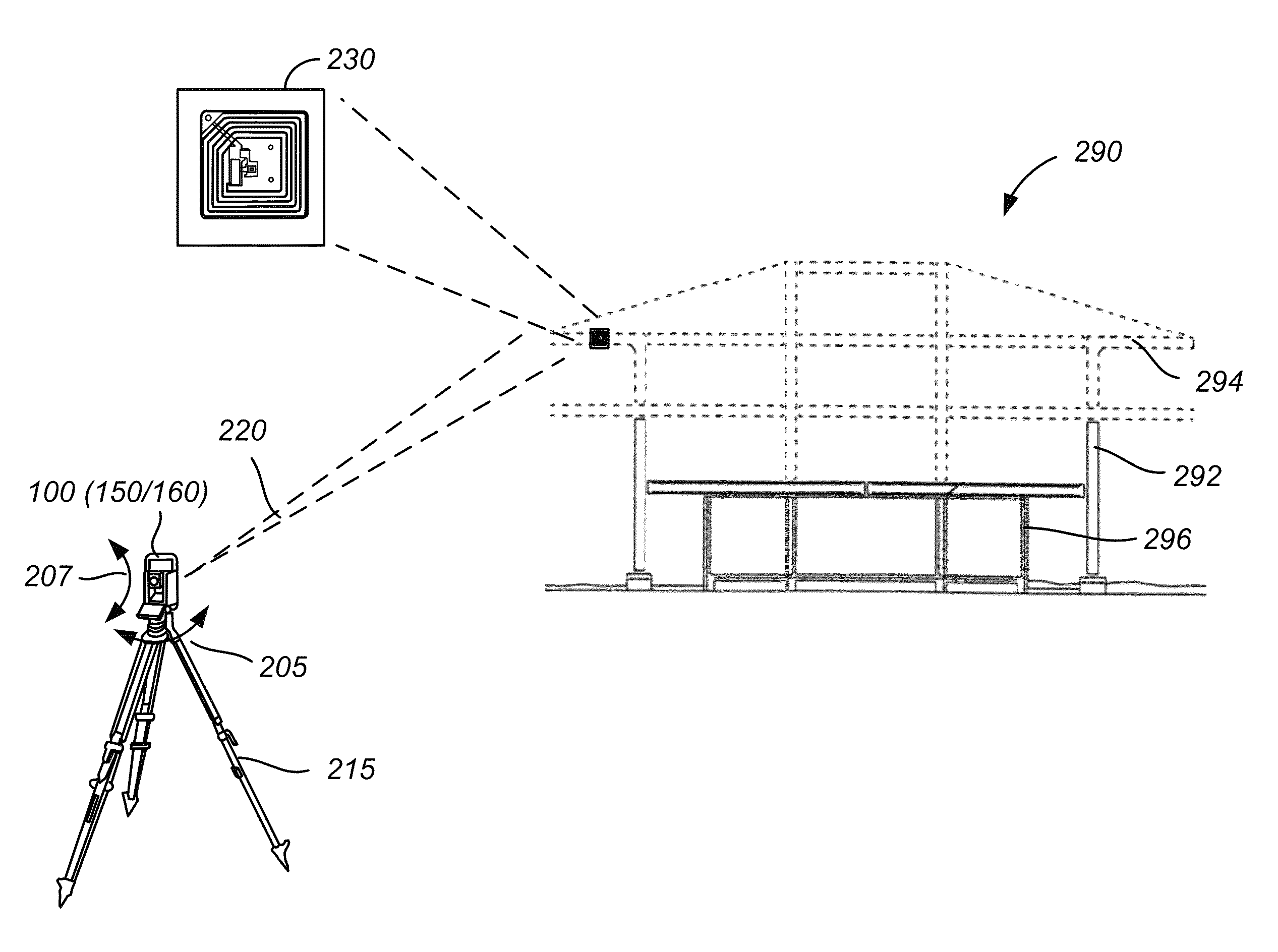
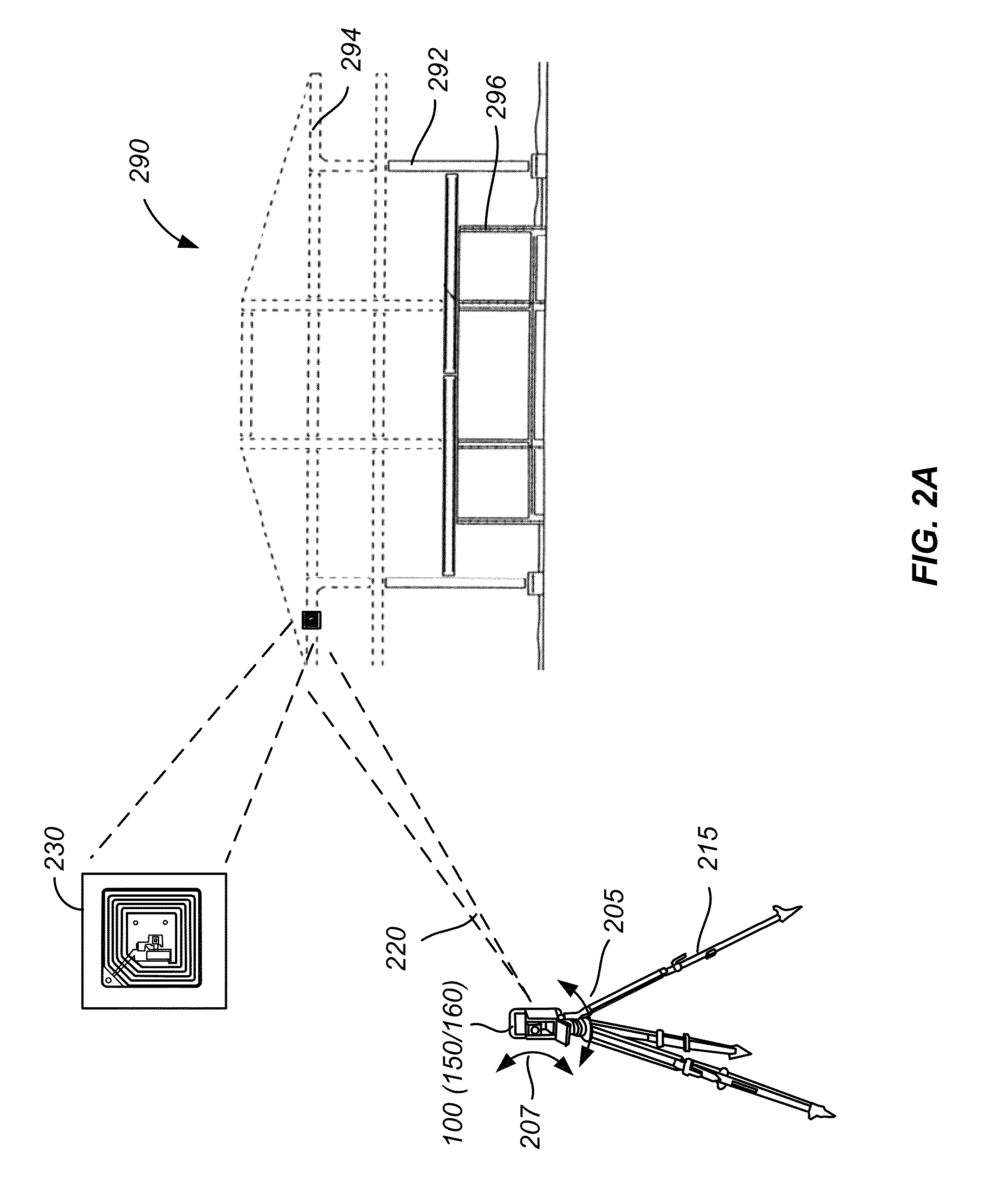
[0019]Embodiments of the present invention relate to methods and systems for RFID-assisted imaging. More particularly, embodiments of the present invention relate to acquiring imaging data of an object using an imaging tool and detecting an RFID tag associated with the object using an RFID reader. RFID data extracted from the RFID tag is associated with the imaging data and stored as metadata along with the imaging data. Merely by way of example, the invention has been applied to forming an intelligent 3D model of a facility using imaging and RFID data.

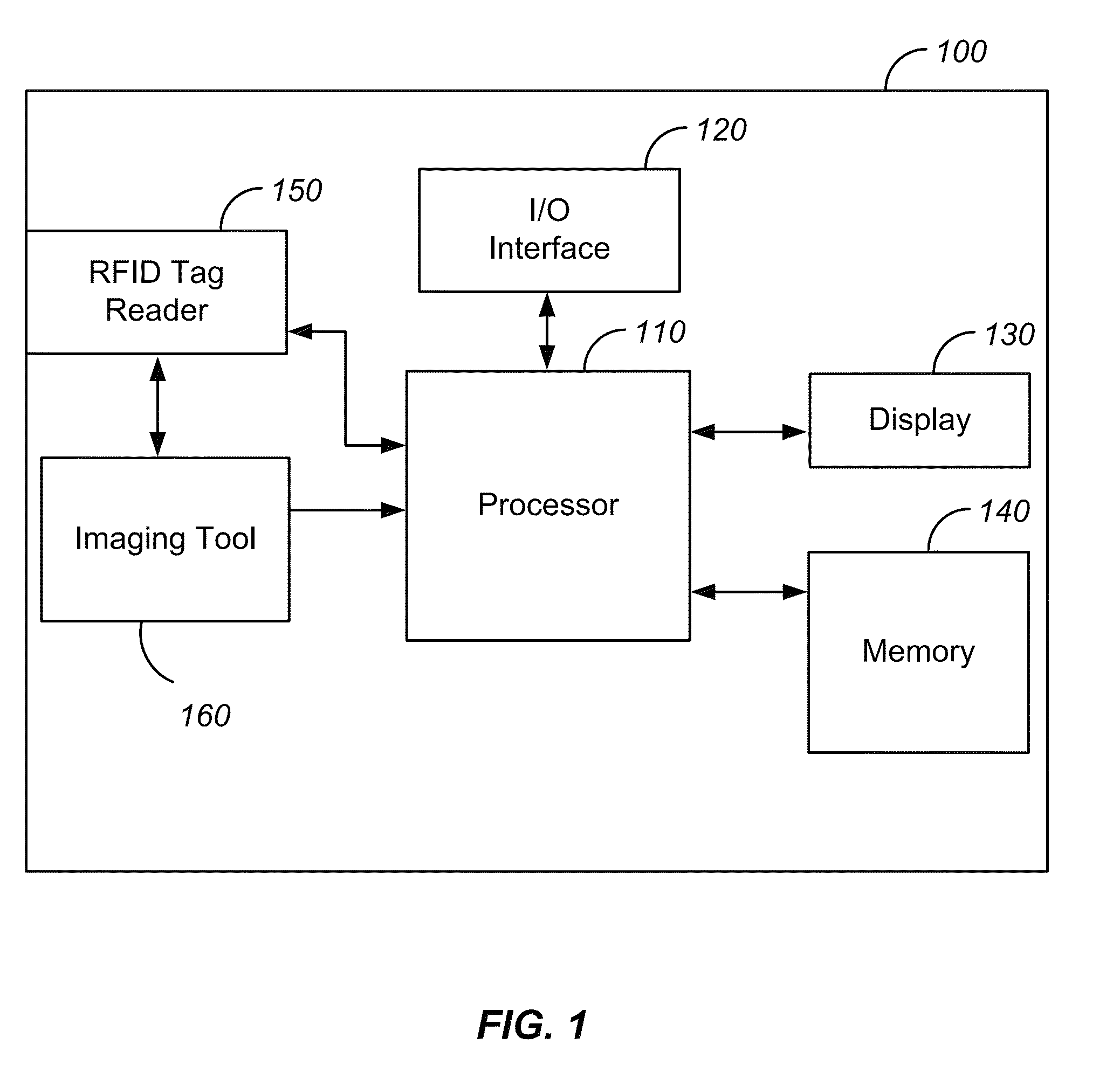
[0020]FIG. 1 is a simplified block diagram of RFID-assisted imaging system 100 that includes imaging tool 160 and RFID tag reader 150 according to one or more embodiments of the invention. The imaging tool 160 can be a camera, a stereoscopic camera, a laser scanner, a photogrammetric system, a 3-D scanner, an optical total station, a consumer-grade camera, a mobile spatial camera, such as is used for mobile data capture in outdoor and...


PUM


Abstract

A method includes acquiring imaging data of a scene using an imaging tool. The method also includes extracting radio frequency identification (RFID) data stored in an RFID tag associated with the scene. The method further includes associating the RFID data with the imaging data.

Description

BACKGROUND OF THE INVENTION[0001]Three-dimensional and two-dimensional imaging tools, such as laser scanners and cameras, measure in an automatic way a large number of points on the surface of an object, and often output a point cloud as a data file. Such imaging tools are useful for capturing visual information of an environment or a facility, and are widely used in construction industry, civil engineering, and asset management, among other applications. For some applications, such as asset management, it is often desirable to integrate asset information with visual information. For example, an operator viewing a scanned image of a plant may want to view the asset information related to a particular asset appearing in the scanned image. The asset information may include, for example, manufacturer's name, model number, specifications, computer-added design (CAD) model, maintenance history, and the like. Conversely, an operator viewing a list of assets may want to see where a particu...

Claims


Application Information

Patent Timeline
Patent Type & Authority Patents(United States)
IPC IPC(8): G06F17/00
CPCG06K7/1097G01C15/002G06K7/10099G06F17/30244H04N2201/3225G06Q10/20H04N1/32128G01C11/02H04N2201/3205H04N1/00342H04N2201/0084G06F16/50G06F16/5854G06K7/10297H04N13/178H04N13/204
Inventor AHERN, BRIANSCHONER, BERND
Owner TRIMBLE NAVIGATION LTD
Why Eureka
Try Eureka