Rapid intervisibility determination in resource-constrained computational environments

a computational environment and resource-constrained technology, applied in the field of airborne computing platforms, can solve the problems of time-consuming intervisibility computation with dted terrain files, required computational resources, and current intervisibility algorithms may not operate efficiently in resource-constrained airborne platforms

Active Publication Date: 2014-05-13
ROCKWELL COLLINS INC
View PDF1 Cites 10 Cited by
  • Summary
  • Abstract
  • Description
  • Claims
  • Application Information

AI Technical Summary

Benefits of technology

[0007]An additional embodiment of the present invention is directed to a computer program product, including: a non-transitory signal-bearing medium bearing one or more instructions for performing a method for providing rapid intervisibility determination, said method including: receiving an active flight plan; creating a terrain pre-processing area based on the active flight plan; determining geodetic coordinates of the terrain pre-processing area; querying and retrieving terrain elevation data (ex. —Digital Terrain Elevation Data (DTED) files) from an on-board database based on said geodetic coordinates of the terrain pre-processing area; processing the DTED files into a data structure; assigning the terrain pre-processing area and the data structure as an active planning area; dividing the active planning area into multiple, uniformly-sized zones in geodetic coordinates; processing the DTED files of the active planning area and storing said DTED files in a two-dimensional (2-D) grid coordinate system via an Ellipsoidal Transverse Mercator (ETM) projection; computing a Line-Of-Sight (LOS) vector between a first location and a second location in Earth-Centered, Earth-Fixed (ECEF) coordinates, the first location being a start location for the vector, the second location being an end location for the vector; converting an ECEF position of the first location to geodetic coordinates; comparing the geodetic coordinates of the first location to geodetic coordinates of boundaries of at least one of the multiple zones to determine which of the multiple zones the first location is located within, the zone in which the first location is determined as being located within being a first zone; converting an ECEF position of the second location to geodetic coordinates; comparing the geodetic coordinates of the second lo

Problems solved by technology

Intervisibility computation with DTED terrain files is a time-consuming process, especially when many intervisibility computations (ex.
Therefore, applications requiring extensive intervisibility computations are currently performed on ground facilities that have access to fast computational device

Method used


Image

  • Rapid intervisibility determination in resource-constrained computational environments
  • Rapid intervisibility determination in resource-constrained computational environments
  • Rapid intervisibility determination in resource-constrained computational environments

Examples


Embodiment Construction

[0023]Reference will now be made in detail to the presently preferred embodiments of the invention, examples of which are illustrated in the accompanying drawings.

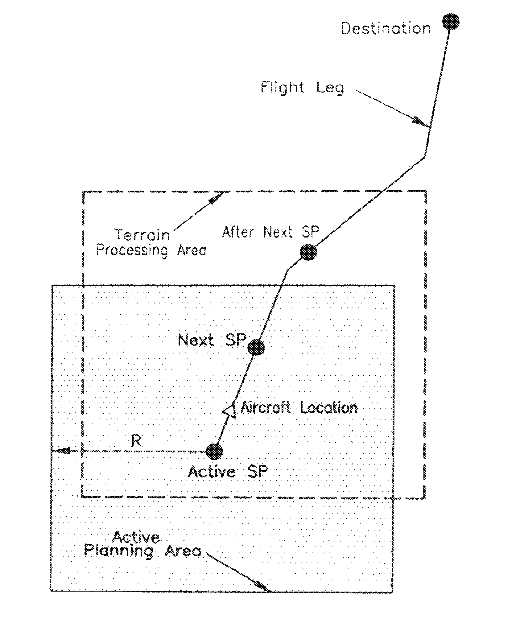
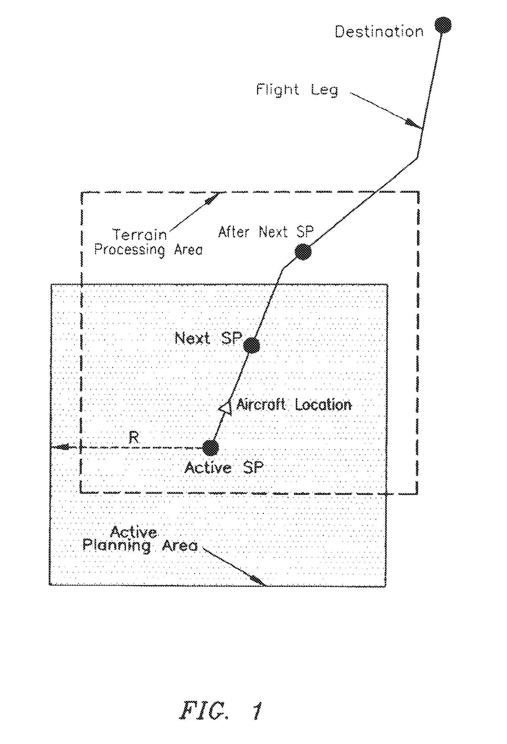
[0024]The intervisibility algorithm of the present invention is specifically designed to operate very efficiently in resource-constrained computational environments that have limited computational resources that need to be shared between many applications. Specific steps may be taken by the algorithm of the present invention to increase computational speed for intervisibility determination, while reducing the required onboard memory and eliminating the use of graphics processing cards for intervisibility computations. In the embodiments disclosed herein, a real-time flight path re-planning application is used as an example to illustrate development of the method steps performed by said algorithm of the present invention. However, the algorithm of the present invention may be applicable to various other applications, such a...


PUM


Abstract

The present invention is a method for providing rapid intervisibility determination in resource-constrained computational environments. The method may be applied to various real-time applications, such as real-time flight planning and ad-hoc network management. The method includes pre-processing terrain elevation data into an ELDETREE data structure, which uses a 3-D grid coordinate system for each zone inside a multi-zone planning area, for expediting intervisibility determination. Along with promoting increased intervisibility computation efficiency, the method further promotes reduced memory usage for intervisibility computation.

Description

FIELD OF THE INVENTION[0001]The present invention relates to airborne computing platforms and particularly to a method for providing rapid intervisibility determination in resource-constrained computational environments.BACKGROUND OF THE INVENTION[0002]Rapid determination of intervisibility between two locations based on Digital Terrain Elevation Data (DTED) is needed for many applications, such as ad-hoc networking and real-time flight planning. These applications may need intervisibility determination for different reasons. For example, to have a robust communication between two nodes in an ad-hoc networking environment, a clear Line-Of-Sight (LOS) between these two nodes is needed. Since there may be many communication nodes (ex. —200 nodes) in an ad-hoc network, it is critical to determine intervisibility rapidly between these many nodes so messages can be transmitted reliably from the starting node to its remote destination node by jumping through many intermediate nodes. For t...

Claims


Application Information

Patent Timeline
IPC IPC(8): G01C21/34
CPCG08G5/0052G01C21/34H04W16/18G08G5/003G06F17/509
Inventor YOUNG, SHIH-YIHJEROME, KRISTEN M.
Owner ROCKWELL COLLINS INC
Why Eureka
Try Eureka