Method for extracting curb of road using laser range finder and method for localizing of mobile robot using curb information of road

a technology of laser range finder and laser range finder, which is applied in the direction of reradiation, distance measurement, instruments, etc., can solve the problems of complex system configuration, many costly equipment, and inability to standardize the topography of the surrounding area, so as to effectively extract the curb and accurately localize the mobile robot

Active Publication Date: 2016-09-27
KOREA UNIV RES & BUSINESS FOUND
View PDF8 Cites 4 Cited by
  • Summary
  • Abstract
  • Description
  • Claims
  • Application Information

AI Technical Summary

Benefits of technology

[0015]The object of the invention is to solve the above problems and in particular, to provide a method for extracting a curb of a road using a laser range finder (LRF) capable of effectively extracting the curb using a single laser range finder in semi-structured road environments having uncertainty.
[0016]The other object of the invention is to solve the problems and in particular, to provide a method for localizing of a mobile robot using curb information of road capable of accurately localizing of the mobile robot by means of the extracted curb information, a differential global positioning system (DGPS) and an inertial measurement unit (IMU).
[0030]According to the invention, it is possible to effectively extract the curb using a single laser range finder in semi-structured road environments.
[0031]Also, it is possible to accurately localize the mobile robot using the extracted curb information, the differential global positioning system (DGPS) and the inertial measurement unit (IMU).

Problems solved by technology

Environmental recognition and a localization are important issues for an outdoor mobile robot which performs specialized duties, such as patrolling or servicing in a road.
One is that surrounding topography is not standardized.
First, many pieces of costly equipment are required.
Second, complex system configurations are required.
However, GPS measurements are degraded in urban environments surrounded by tall buildings because of multipath errors and blocked satellite in view.
This results in imprecise measurements.
It is hard to operate at night and it is strongly influenced by weather changes because it is not strong in low illumination.
However, this technique reduces a lateral error of the vehicle through map matching of the extracted curb point, but does not correct the orientation of the mobile robot.

Method used


Image

  • Method for extracting curb of road using laser range finder and method for localizing of mobile robot using curb information of road
  • Method for extracting curb of road using laser range finder and method for localizing of mobile robot using curb information of road
  • Method for extracting curb of road using laser range finder and method for localizing of mobile robot using curb information of road

Examples


Embodiment Construction

[0037]Hereinafter, preferred embodiments according to the present invention will be explained in detail referring to attached drawings.

[0038]Road environments and a mobile robot according to the present invention will be explained, before explanation about a method for extracting a curb using a lager range finder according to the present invention.

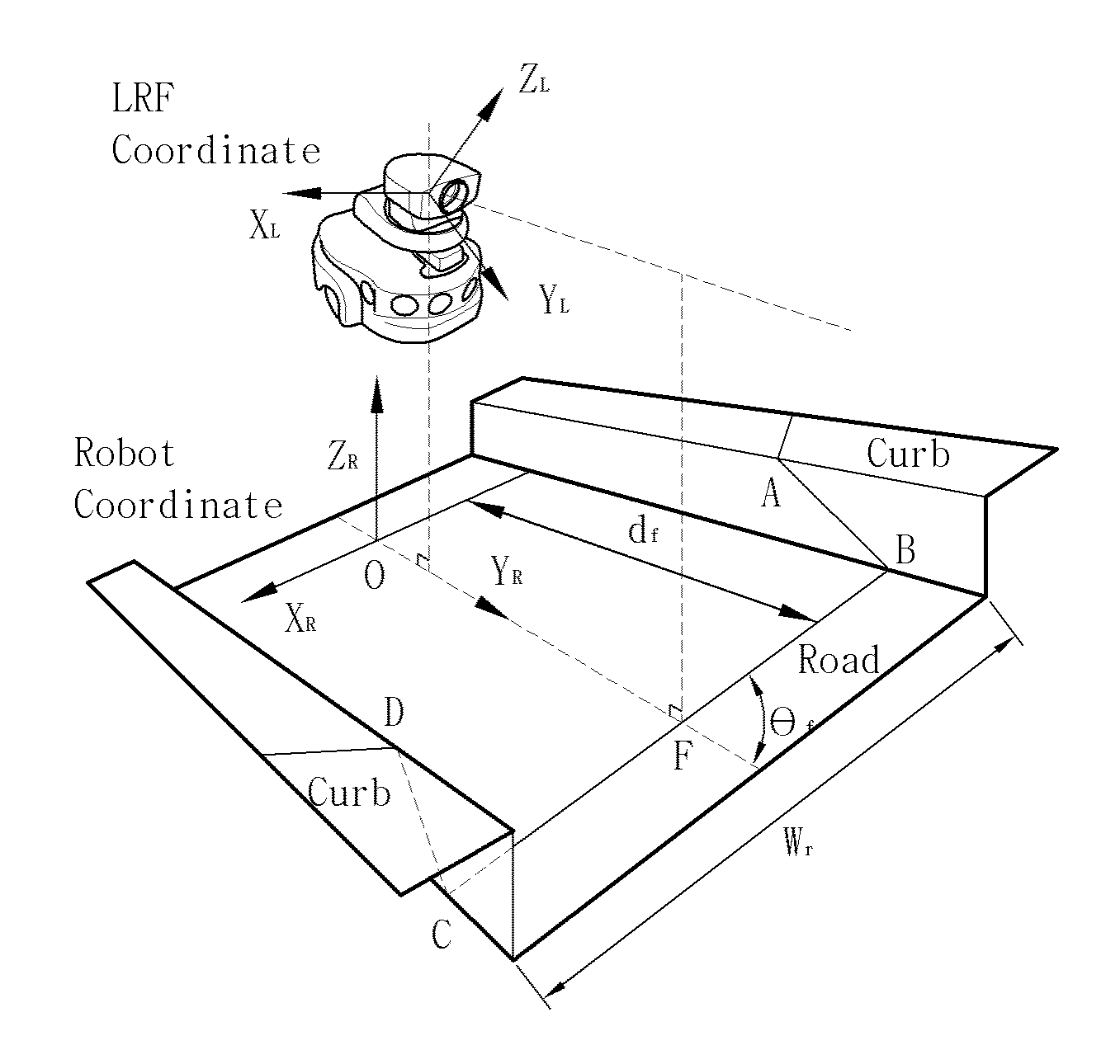
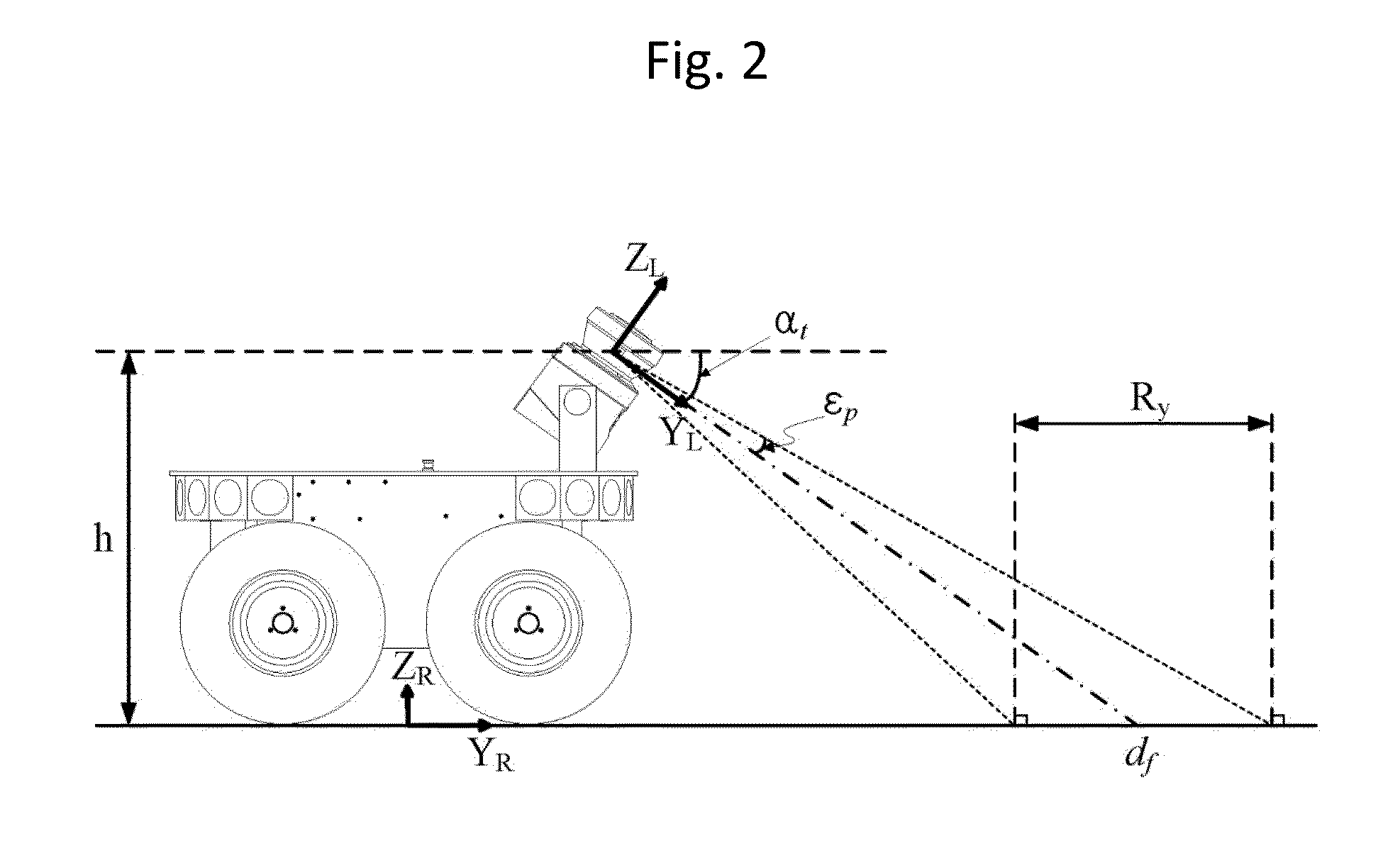
[0039]FIGS. 1 and 2 represent a structure of coordinate frames of a mobile robot and a laser range finder in semi-structured road environments. A single laser range finder having a tilting angle at is used to extract a road feature, such as a road surface, a curb and an obstacle. In flat road conditions, a look ahead distance of the laser range finder is df. The look ahead distance is determined by the tilting angle of the laser range finder. However, a pitch angle of the mobile robot is affected by an uneven road surface. Therefore, the look ahead distance of the laser range finder varies in a look ahead direction of the mobile robot.

[004...


PUM


Abstract

The invention relates to a method for extracting a curb of a road using a laser range finder and a method for localizing of a mobile robot using curb information of a road. The method for extracting the curb of the road using the laser range finder includes extracting a road surface and line segments from scan data of the laser range finder, extracting a plurality of curb candidate line segments among the line segments on the basis of an angle between the road surface and the line segment, extracting a plurality of curb candidates having a plurality of curb properties, wherein each of the plurality of curb candidates is generated by combining the couple of the curb candidate line segments, and applying the plurality of the curb candidates to a Kernel Fisher Discriminant Analysis to extract a final curb.

Description

CROSS-REFERENCE TO RELATED APPLICATION[0001]This application claims the benefit under 35 U.S.C. §119(a) of Korean Patent Application No. 10-2014-0086346, filed on Jul. 9, 2014, in the Korean Intellectual Property Office, the entire disclosure of which is incorporated herein by reference.FIELD OF THE INVENTION[0002]The invention relates to a method for extracting a curb of a road using a laser range finder and a method for localizing of a mobile robot using curb information of a road and in particular to a method for extracting a curb of a road using a laser range finder and a method for localizing of a mobile robot using curb information of a road for extracting a curb in a semi-structured road environment having little change of the road shape and measuring a position of the mobile robot using the extracted curb, a differential global positioning system (DGPS), and an inertial measurement unit (IMU).BACKGROUND DESCRIPTION OF THE RELATED ART[0003]Environmental recognition and a loca...

Claims


Application Information

Patent Timeline
Patent Type & Authority Patents(United States)
IPC IPC(8): G05D1/02G01C3/08G01C21/18G01C21/16G01C21/14G01S17/42G01S7/48G01S17/93G01S17/931
CPCG05D1/0231G01C3/08G01S7/4802G01S17/42G01S17/936Y10S901/01G05D1/024G05D1/0274G05D2201/0209G01C7/04G01S17/931G06V20/588G06F18/2132B60W40/06
Inventor CHUNG, WOOJINLEE, HYUNSUK
Owner KOREA UNIV RES & BUSINESS FOUND
Why Eureka
Try Eureka