Three-dimensional simulation digital information navigation channel system and its implementing method

A three-dimensional simulation and digital information technology, applied in the field of channel information, can solve the problem of insufficient spatial cognition, restricting the progress of three-dimensional representation technology of spatial information, 3DGIS engineering application practice and other problems

Inactive Publication Date: 2008-04-02
长江航道局 +1
View PDF0 Cites 33 Cited by
  • Summary
  • Abstract
  • Description
  • Claims
  • Application Information

AI Technical Summary

Problems solved by technology

Existing 3D GIS research focuses on 3D visualization technology, and the research on the more basic 3D GIS spatial cognition problem is not enough, which also restricts the progress of spatial information 3D representation technology and 3D GIS engineering application practice

Method used


Image

  • Three-dimensional simulation digital information navigation channel system and its implementing method
  • Three-dimensional simulation digital information navigation channel system and its implementing method
  • Three-dimensional simulation digital information navigation channel system and its implementing method

Examples


Embodiment Construction

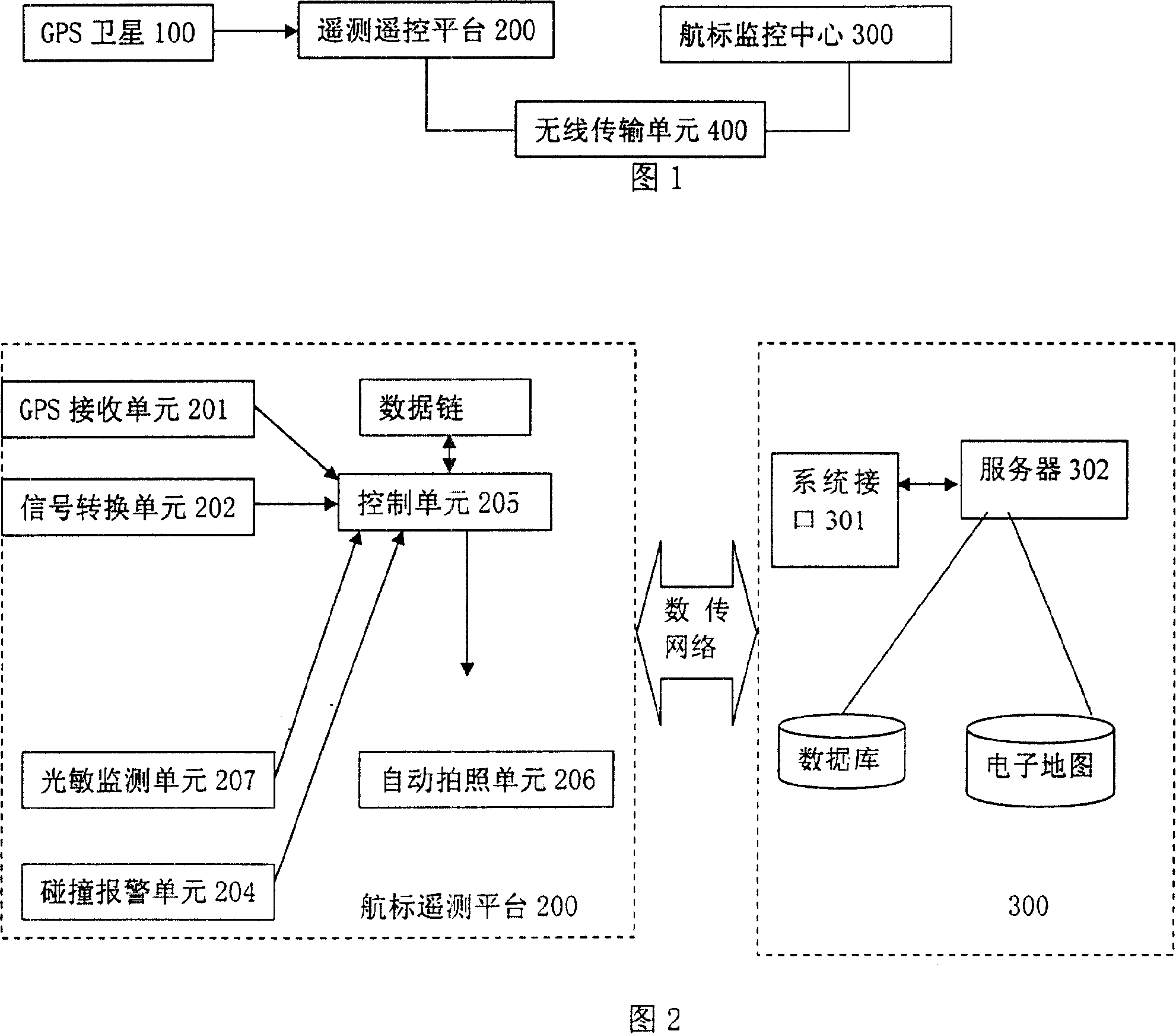
[0019] As shown in Figure 1, the GPS satellite 100 transmits a signal to the telemetry remote control platform on the object on the waterway, where the telemetry remote control platform on the object on the waterway is the telemetry remote control platform 200 and the navigation mark monitoring center 300 of the navigation light, the telemetry of the navigation light The remote control platform 300 communicates with the navigation mark monitoring center 300 through the wireless transmission system 400 . The wireless transmission system 400 is a GPRS or CDMA system. The system interface 301 of the navigation mark monitoring center 300 is used to communicate with the wireless communication system; the server 302 is used for database and management, navigation of the three-dimensional simulation electronic map of the waterway and query and analysis of objects on the waterway. The server 302 is shown in FIG. 6 .

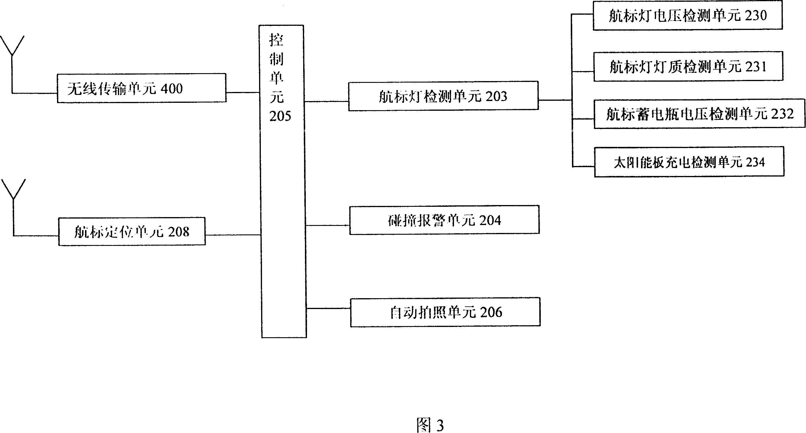
[0020] As shown in Figures 2 and 3, the telemetry remote control p...


PUM


Abstract

The present invention discloses a 3D simulation digital information channel system and the realization method thereof, wherein, a system comprises a GPS satellite used for the positioning detection for objects on a channel, a telemetry remote control platform for the objects on the channel, which is used to detect the states of the objects on the channel and execute wireless communication, a navigation mark monitoring center used for the 3D display monitoring of the objects of the channel and on the channel and / or around the channel, a wireless communication system used to transmit data among the navigation mark monitoring center and a telemetry remote control platform for the objects on the channel and / or a mobile terminal. The navigation mark monitoring center comprises a system interface used for the communication with the wireless communication system, and a server used for a database as well as management, the display browsing of channel 3D simulation electronic graph and the query analysis of the objects on the channel. The system can veritably reflect the status of the channel and the objects on the channel with three dimensions in a computer, which is a 3D model having an important spatial pattern and visual function in 3DGIS.

Description

technical field [0001] The invention belongs to waterway information technology, and in particular relates to a three-dimensional simulation digital information waterway system and a realization method. Background technique [0002] With the continuous development of computer three-dimensional (3D) display technology, the requirement for visualization of map symbols is becoming increasingly urgent. The contradiction between the abstraction and image of map symbols returns to three-dimensional visualization in the process of opposite and spiral development, which leads to the three-dimensional visualization of spatial information becoming one of the important features of GIS development. The 3D visualization technology makes the traditional 2D and static map representation develop towards the 3D and dynamic scene representation. With the support of the spatial database, virtual reality (VR) technology can be used to build a virtual environment. After entering this environment...

Claims


Application Information

Patent Timeline
Patent Type & Authority Applications(China)
IPC IPC(8): G08C17/02G06F17/30G06T17/50G06T15/00G06T17/05
Inventor 杨瑞庆朱庆李昕吴立
Owner 长江航道局
Why Eureka
Try Eureka