Rapid blocking and grating algorithm of laser radar point clouds data

A technology of lidar and point cloud data, applied in the field of information processing technology, can solve the problems of high space and time complexity of algorithms, irregular geometric relationship of data points, etc., to reduce the process of neighborhood search, reduce requirements, and save calculation. The effect of resources

Inactive Publication Date: 2008-12-17
覃驭楚 +1
View PDF0 Cites 23 Cited by
  • Summary
  • Abstract
  • Description
  • Claims
  • Application Information

AI Technical Summary

Problems solved by technology

However, the massive point cloud data acquired by lidar is an irregular discrete point data set, and the geometric relationship between data points is irregular. In the process of using these discrete point data to generate rasterized digital products, it is necessary to carry out grid point neighbors. Domain search and sorting, while the amount of data generated by lidar data in the process of obtaining high-resolution ground information reaches GB or even TB levels, the sorting and neighborhood search of conventional block and rasterization algorithms make the space and time of the algorithm The complexity is very high, and related researchers have explored the use of a large number of computer networks to form a distributed computing environment to solve this problem (http: / / www.geongrid.org / science / lidar.html), but for conventional data processing and data In terms of product production, data partitioning and rasterization have become a bottleneck problem

Method used


Image

  • Rapid blocking and grating algorithm of laser radar point clouds data

Examples


Embodiment Construction

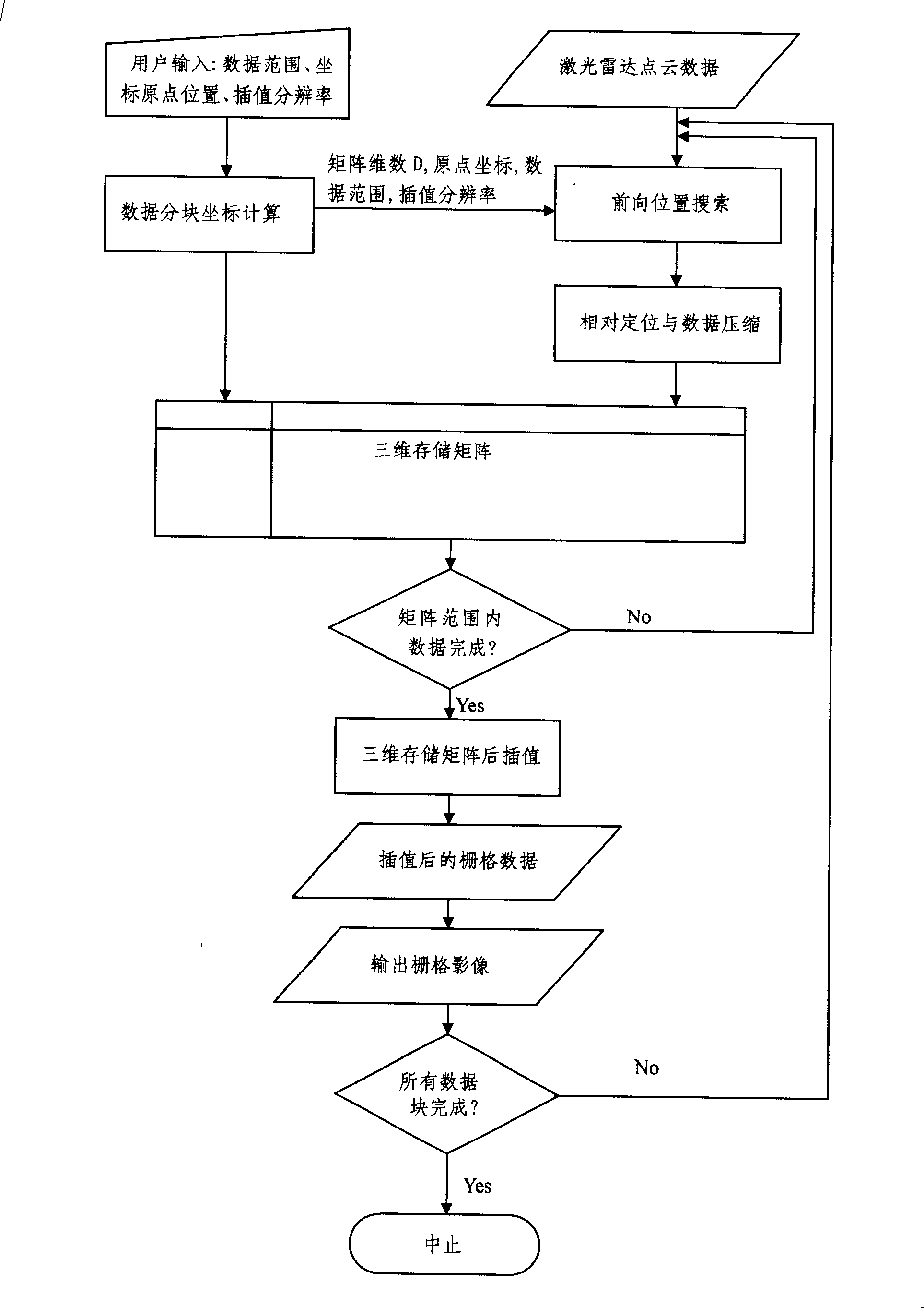
[0006] Such as figure 1 As shown, the present invention proposes a block fast and rasterization algorithm for laser radar point cloud data, which includes: a three-dimensional storage mode for laser radar point cloud data, and adaptively selects a suitable Data sub-block size, using forward position search and relative positioning strategy to realize the compression of lidar point cloud data, thereby reducing the neighborhood search and I / O process in the process of discrete point cloud data block and rasterization, and realizing laser Fast block and rasterization of radar point cloud data. The complete technical process is as follows:

[0007] ●Establish a three-dimensional storage matrix of laser radar point cloud data: each laser radar point data contains additional information such as three-dimensional space position coordinates (X, Y, Z) and reflection intensity (density) and echo times under a certain spatial reference system , where the three-dimensional space coordin...


PUM


Abstract

A fast blocking and rasterizing algorithm of laser radar point cloud data is a technique in the earth observation field. The invention discloses a fast blocking and rasterizing method of the laser radar point cloud data, which comprises the storage organization mode and the relative positioning method of the laser radar point cloud data, the target position forward search and the automatic blocking method of the laser radar point cloud data, the interpolation and the post-treatment based on a three-dimensional storage matrix. The fast blocking and rasterizing method can reduce the requirements on hardware of a computer platform during the production process of grid data of the mass laser radar point cloud data, reduce the consumption of the computing resources during the rasterizing process of the mass laser radar point cloud data, and realize the fast blocking and the rasterizing of the laser radar point cloud data.

Description

technical field [0001] The present invention is a technology in the field of earth observation. The present invention reduces the requirements for computing platform hardware during the rasterization process of massive laser radar point cloud data, reduces the consumption of computing resources, and can realize laser radar point cloud data Fast block and rasterization, the present invention is an information processing technology with application value. Background technique [0002] LiDAR (Light Detection And Ranging, LiDAR for short) is a combination of laser, Global Positioning System (GPS) and Inertial Navigation Systems (Inertial Navigation Systems, INS) technologies to quickly acquire three-dimensional high spatial resolution of ground and ground targets. LiDAR technology, together with imaging spectroscopy and synthetic aperture radar (SAR), is listed as the core information acquisition and processing technology of the Earth Observation System (EOS) program. In the pa...

Claims


Application Information

Patent Timeline
Patent Type & Authority Applications(China)
IPC IPC(8): G01S7/48G01S17/02
Inventor 覃驭楚牛铮
Owner 覃驭楚
Why Eureka
Try Eureka