On-board SAR image automatic target positioning method

A target positioning and image technology, applied in the direction of radio wave reflection/re-radiation, using re-radiation, measuring devices, etc., can solve problems that affect the convergence direction of iterative algorithms, low positioning accuracy, and deviation of positioning results, so as to avoid the target Effects of confusion, high positioning accuracy, and fast speed

Inactive Publication Date: 2009-01-07
BEIHANG UNIV
View PDF0 Cites 21 Cited by
  • Summary
  • Abstract
  • Description
  • Claims
  • Application Information

AI Technical Summary

Problems solved by technology

[0004] The traditional SAR image target positioning method is generally to carry out reference point positioning, that is, find some reference points (man-made or natural) whose positions are already known within the SAR imaging range, and then determine the relative position of other target points in the image. The position of the reference point; this type of method relies on high-precision ground control points, and needs to determine the position of the control points on the image through manual interpretation, so it is difficult to achieve real-time processing
At present, there are not many specialized articles on airborne SAR target positioning. In the common target positioning algorithms, most of them ignore the influence of the earth model on the positioning accuracy, and directly use the geometric relationship of the airborne SAR system imaging principle to calculate the target point. The relative deviation relationship with the position of the off-board point, and then obtain the geographic coordinates of the target according to the geographic location of the off-board point and the course of the carrier aircraft; although this type of method can achieve fast positioning, its positioning accuracy is not high
However, some spaceborne SAR automatic target positioning methods consider the influence of the earth model on the positioning accuracy, but ignore the influence of the iterative initial value point on the target positioning; the setting of the iterative initial value point affects the convergence direction of the iterative algorithm. In the case where the initial point setting is inconsistent with the SAR working mode, the target will be confused, which will cause a large deviation in the final positioning result

Method used


Image

  • On-board SAR image automatic target positioning method
  • On-board SAR image automatic target positioning method
  • On-board SAR image automatic target positioning method

Examples


Embodiment Construction

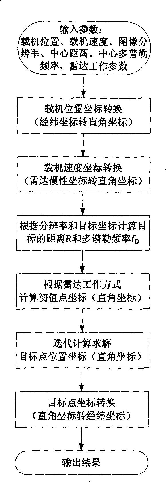
[0021] First briefly introduce several different coordinate systems used in the present invention:

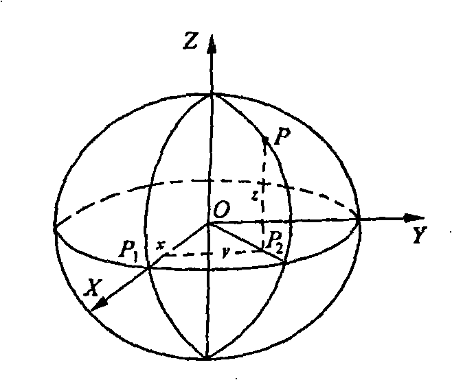
[0022] (1) Space Cartesian coordinate system: take the center of the earth O as the origin of the coordinates, the X-axis is the intersection line between the initial meridian plane and the equator, pointing to the intersection of the half branch of the Greenwich meridian and the equator; the Z-axis is along the rotation axis of the earth Pointing to the positive North Pole; the Y axis is also in the equatorial plane, making this coordinate system constitute a right-handed Cartesian coordinate system O-XYZ. In this coordinate system, the position of point P is represented by (x, y, z), such as figure 2 shown.

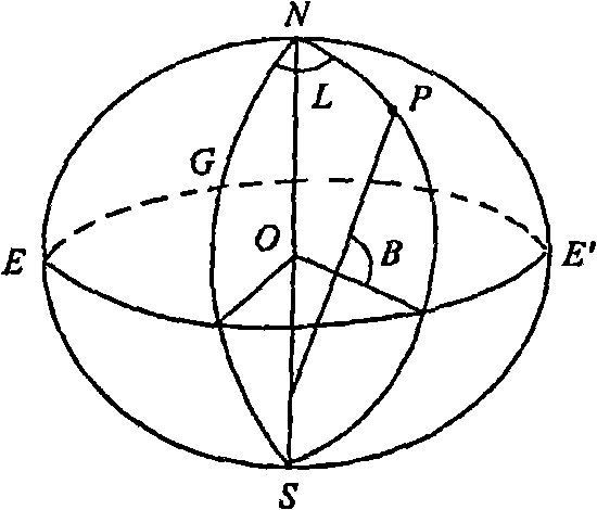
[0023] (2) WGS84 geographic coordinate system: use a reference ellipsoid to model the earth, the center of the ellipsoid coincides with the center of mass of the earth, the minor axis of the ellipsoid coincides with the rotation axis of the earth, and the starting meri...


PUM


Abstract

The invention relates to an airborne SAR image automatic target positioning method, which convert the coordinates of a target in the SAR image into an actual geographic coordinates of the target on the earth by utilizing the flight information (location, speed, etc.) of an aerial carrier and the SAR image information (resolution, center distance, central Doppler frequency, etc.). Based on a range-Doppler equation, the invention combines an earth model equation to carry out an target location, which not only can realize an absolute localization without a control point, but also considers the influence of the earth model on positioning accuracy; on the other hand, Taylor series expansion is used for carrying out the linearization of nonlinear equations; an iterative method is adopted to solve the equation, thus improving the positioning speed; meanwhile, the initial value point of an iterative computation is appropriately selected according to the operation mode of radar, thereby controlling a converging direction in the iteration and avoiding a target confusion. As a positioning method without the control point, the automatic target positioning method of the invention has the advantages of high accuracy and high speed, thereby being capable of carrying out a real-time processing and suitable to various airborne SAR systems.

Description

technical field [0001] The invention relates to an automatic target positioning method of an airborne SAR image, which converts the coordinates of the target in the SAR image into the actual geographic coordinates of the target on the earth by using the flight information of the aircraft and the SAR image information, and is suitable for use in the airborne SAR system Accurate positioning of the target. Background technique [0002] Synthetic Aperture Radar (SAR) itself is an active sensor that uses microwave perception. With a certain penetrating detection capability, it can detect a certain depth of subsurface or other camouflaged or covered targets, which makes SAR have great application potential in target detection. [0003] Usually, the result of target detection is the position of the target in the SAR image. In practical applications, whether in military aspects, such as conventional overseas reconnaissance and positioning, aircraft navigation, fire control, target...

Claims


Application Information

Patent Timeline
Patent Type & Authority Applications(China)
IPC IPC(8): G01S13/90
Inventor 张耀天胡睿孙进平
Owner BEIHANG UNIV
Why Eureka
Try Eureka