Absolute positioning method based on fusion of visual inertial odometer and intermittent RTK (Real-Time Kinematic)

An absolute positioning and odometer technology, used in satellite radio beacon positioning systems, surveying and navigation, and navigation calculation tools, etc., can solve problems such as easy occlusion or relative positioning, large computational load, divergence, etc., to ensure safety. and stability, real-time robust absolute positioning, stable absolute positioning effect

Pending Publication Date: 2022-05-27
NORTHWESTERN POLYTECHNICAL UNIV
View PDF0 Cites 0 Cited by
  • Summary
  • Abstract
  • Description
  • Claims
  • Application Information

AI Technical Summary

Problems solved by technology

As a highly flexible flying vehicle, the quadrotor drone is especially suitable for the requirements of infrastructure autonomous inspection tasks. However, traditional quadrotor drones either rely on GPS positioning or visual-inertial odometer positioning. There are disadvantages of being susceptible to occlusion or relative positioning, which cannot meet the needs of infrastructure autonomous detection tasks for high-precision absolute positioning
However, since the situation of no GPS for a long time is not considered, the fusion in the case of a long GPS interruption time will cause discontinuous positioning results due to the long-term drift of the visual-inertial odometer, which will affect the safety of the aircraft. sex and job stability
[0004] The article "A general optimization-based framework for local odometry estimation with multiple sensors" proposes a nonlinear optimization framework, using nonlinear factor graph optimization to realize the tightly coupled fusion method of GPS and visual inertia, but because the discontinuity of GPS is not considered , and the amount of calculation is large, it is impossible to provide real-time absolute positioning for UAVs in infrastructure autonomous detection scenarios
[0005] Although the existing GPS fusion visual-inertial odometry method can achieve better accuracy in ordinary outdoor scenes, most of them do not consider the situation of intermittent GPS, and do not consider the drastic changes in pose during the fusion process. The impact of system stability can easily lead to instability or even divergence of the aircraft control system during the fusion process

Method used


Image

  • Absolute positioning method based on fusion of visual inertial odometer and intermittent RTK (Real-Time Kinematic)
  • Absolute positioning method based on fusion of visual inertial odometer and intermittent RTK (Real-Time Kinematic)
  • Absolute positioning method based on fusion of visual inertial odometer and intermittent RTK (Real-Time Kinematic)

Examples


specific Embodiment

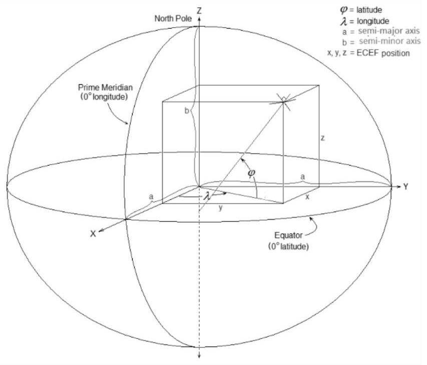
[0120] 1. RTK-VIO initialization. The positioning information obtained by RTK and the positioning information estimated by VIO are located in different reference coordinate systems. RTK uses the earth's geographic coordinate system as the reference system, which is represented by longitude, latitude and ellipsoid height respectively, while the VIO coordinate system is usually a local Cartesian The coordinate system takes the starting point as the coordinate origin, the Z axis of the coordinate system is perpendicular to the horizontal plane, and the position is represented by a three-dimensional vector and the attitude is represented by a quaternion. In order to integrate the two, it is first necessary to transform them into a unified reference system, and to achieve absolute positioning, the transformed coordinate system must be fixed at a certain point on the earth and remain unchanged in different operations. According to habit, select a point with a fixed latitude, longitu...


PUM


Abstract

The invention discloses a visual inertial odometer and discontinuous RTK fused absolute positioning method, which comprises the following steps of: firstly, initializing an RTK-VIO system, and finishing conversion between a geosphere geographic coordinate system where an RTK is located and a VIO coordinate system and an ENU coordinate system; then acquiring an RTK value and a VIO value of the current position, and converting the RTK value and the VIO value into an ENU coordinate system; constructing an observation residual optimization problem by using the pose estimated by the VIO and the pose estimated by the RTK; 3, a sliding window is constructed, the residual errors obtained in the step 3 are added into the sliding window according to the time sequence of occurrence events of the high-quality RTK signals, rolling optimization is carried out, and a latest calibration event is obtained; and finally, the calibration event is smoothed, and safe and stable flight of the unmanned aerial vehicle is ensured. According to the method, the defects of error accumulation of the visual inertial odometer and incapability of accurately positioning the RTK due to intermittent shielding are overcome, and real-time robust absolute positioning relative to the tangent space of a geographic coordinate system is realized.

Description

technical field [0001] The invention belongs to the technical field of positioning, and in particular relates to a fusion positioning method. Background technique [0002] Infrastructure inspection can help relevant departments to regularly assess the health status of infrastructure, maintain damaged facilities in a timely manner, and prevent and prevent disasters. Traditional infrastructure detection mainly relies on manual carrying of equipment or manual remote operation, which has many disadvantages such as high personal risk, low operation efficiency, and high cost. Benefiting from the development of robotics and artificial intelligence in recent years, autonomous detection infrastructure has gradually attracted the attention of researchers. As a highly flexible flying vehicle, quadrotor UAV is especially suitable for the requirements of autonomous detection tasks of infrastructure. However, in traditional quadrotor UAVs either rely on GPS positioning, or rely on visual...

Claims


Application Information

Patent Timeline
Patent Type & Authority Applications(China)
IPC IPC(8): G01C21/16G01C21/20G01S19/43G01S19/47G06F17/16G06F17/18
CPCG01C21/1652G01C21/188G01C21/20G01S19/47G01S19/43G06F17/16G06F17/18
Inventor 黄攀峰王志祥张夷斋张帆闫雨晨杨奇磊
Owner NORTHWESTERN POLYTECHNICAL UNIV
Why Eureka
Try Eureka