Method and system based on GIS electronic map interactive operation

A technology for electronic map and operation information, applied in the application field of GIS system, can solve the problems such as the inability to meet the needs of military strategic analysis and force deployment and deduction of real-time information exchange and interactive operation, the inability of users to share and interactive operation of real-time information, and the inability to achieve

Inactive Publication Date: 2009-02-25
GUANGDONG VTRON TECH CO LTD
View PDF0 Cites 6 Cited by
  • Summary
  • Abstract
  • Description
  • Claims
  • Application Information

AI Technical Summary

Problems solved by technology

[0005] At present, users use browsers to access electronic map data on the server, only to obtain and display the data on the server, or submit data to the server. The user operations of each client are independent of each other, and there is no sequence relationship. Users cannot share real-time information and interactive operation
In particular, it cannot meet the needs of real-time information exchange and interactive operations for military strategic analysis and force deployment deduction in the armed police, public security, military and other industries
[0006] If multiple users operate on the same electronic map at the same time, mark icons on the map, and conduct simulated collaborative exercises on the map, all clients are required to see the operations of other users on the map in real time, or modify other users The marked data cannot be implemented under the browser version of the WebGIS architecture; if it is necessary to synchronize the map display scales of each client in real time, zoom in and out, and move the map at the same time, it cannot be realized under the WebGIS architecture, so based on the WebGIS architecture The following applications are not suitable for real-time interactive operation applications of multiple clients

Method used


Image

  • Method and system based on GIS electronic map interactive operation
  • Method and system based on GIS electronic map interactive operation
  • Method and system based on GIS electronic map interactive operation

Examples


Embodiment 1

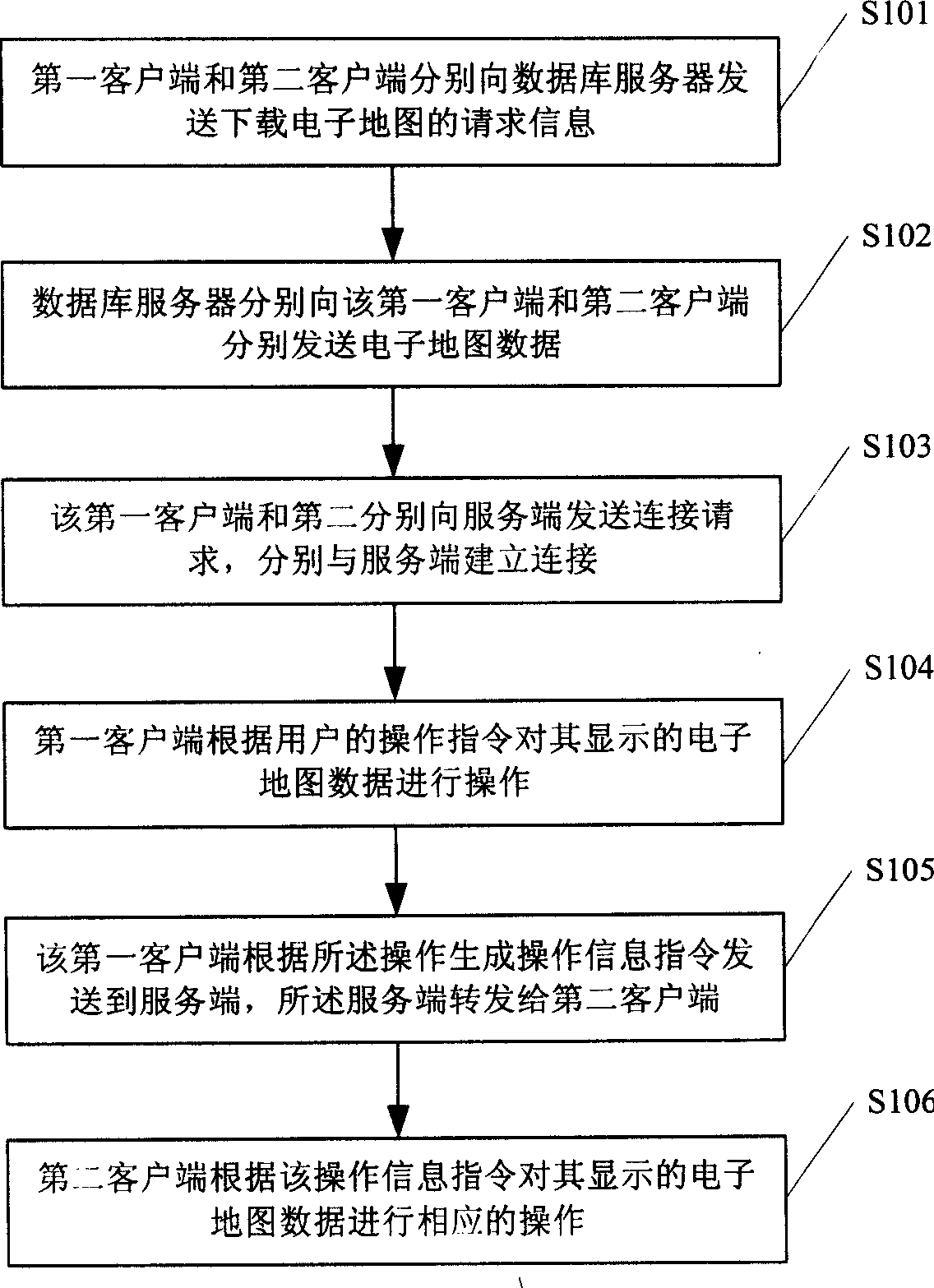
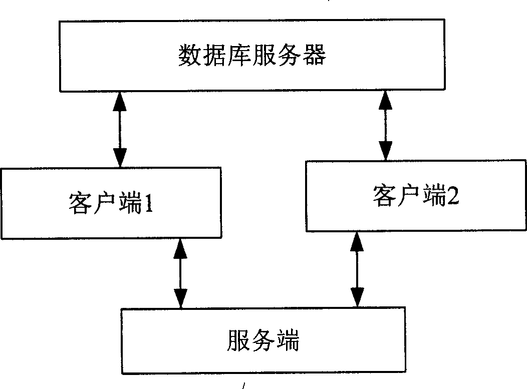
[0036] The user selects an icon on the icon selection toolbar of a certain client, and clicks the left mouse button on a certain target point on the electronic map displayed by the client. The icon is displayed in the corresponding position on the map, and the client will immediately Start a communication process, compose the icon marking instruction, icon identification and marking position into a communication data packet, and send this data packet to the server, and the server receives the client instruction packet. It can directly send the data without any processing. The package is sent to all other clients. After the other clients receive the data package, they will analyze the data, take out the instruction, icon identification and label location coordinates respectively, execute the icon labeling instruction, and mark the same in the corresponding position on the respective displayed electronic map. Icon.

Embodiment 2

[0038] The user selects an icon on the electronic map displayed on the client with the left mouse button on a certain client, and clicks the magnification icon on the icon operation toolbar, the icon on the electronic map is magnified proportionally, and the client starts a communication immediately In the processing process, the icon enlargement instruction and the icon logo are combined into a communication data packet, and the data packet is sent to the server. The server receives the client instruction packet and can directly send the data packet to all other customers without any processing. After receiving the data packet, the other clients perform data analysis, respectively take out the icon enlargement instruction and icon identification, execute the icon enlargement instruction, and scale the corresponding icon on the electronic map displayed.

[0039] Implementation Three

[0040] On a certain client, the user clicks the zoom button on the toolbar with the mouse, and th...

Embodiment 4

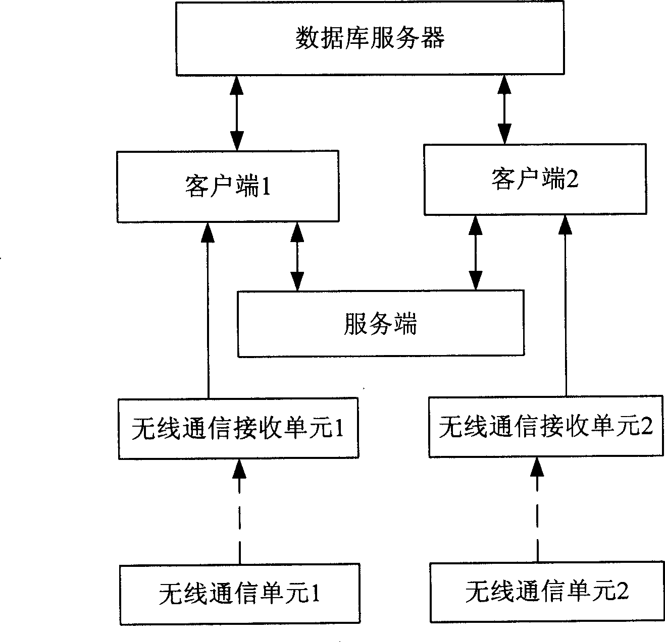
[0042] The user uses the remote control to control the electronic map displayed on the client at a certain client, and presses the left button on the transmitter of the remote control once, the transmitter of the remote sends the command to the receiver of the remote, and the receiver of the remote receives the control command. And send the instruction to the client connected to it, and the client will execute the operation of moving the map to the left for a certain distance. At this time, the client will start a communication processing process, and the map left instruction and the moving distance information will form a communication data packet. , And send this data packet to the server. The server receives the client instruction packet without any processing, and directly sends the data packet to all other clients. After the other clients receive the data packet, they perform data analysis and take out the map respectively. Move left command, execute the operation of moving t...


PUM


Abstract

The invention discloses a method for interactive operation based on GIS electronic maps and a system thereof. The method comprises the following steps: a first client and a second client send request information for downloading electronic maps to a database server respectively, and receive electronic map data sent by the database server for display; the first client and the second client send access request to a service end, and are accessed to the service end respectively; the first client operates the displayed electronic map data according to the operating instructions of users, and sends the electronic map data to the service end according to the operation information instructions generated through the operation; the second client operates the displayed electronic map data correspondingly according to the operation information forwarded by the service end. By adopting the method for interactive operation based on GIS electronic maps, the electronic map data information and the operations of all of the clients are synchronized in real time, thus ensuring cooperation between a plurality of clients well and achieving interaction of information.

Description

Technical field [0001] The invention relates to the application field of GIS systems, in particular to a method and system for interactive operation based on GIS electronic maps. Background technique [0002] GIS (Geography Information System) is a high and new technology that integrates computer graphics and databases to store and process spatial information. It organically combines geographic location and related attributes, and combines spatial information and Its attribute information is accurate and true, with pictures and texts output to users, meeting the requirements of urban construction, enterprise management, and residents' life for spatial information. With its unique spatial analysis function and visual expression function, various auxiliary decision-making can be made. [0003] Among the existing technologies, WebGIS technology is the most widely used technology for operating electronic maps. WebGIS is a fusion of GIS technology and Internet technology. Using a gene...

Claims


Application Information

Patent Timeline
Patent Type & Authority Applications(China)
IPC IPC(8): G06F17/30H04L29/06
Inventor 程百强林良辉聂晋施宁
Owner GUANGDONG VTRON TECH CO LTD
Why Eureka
Try Eureka