Electronic information system for earth monitor and method thereof

A land and electronic technology, applied in satellite radio beacon positioning system, radio wave measurement system, measuring device, etc., can solve problems such as inability to make absolute positioning, long field work cycle, heavy statistics and sorting workload, etc., to ensure Real-time update, overcome the long operation cycle, and realize the effect of electronization

A land and electronic technology, applied in satellite radio beacon positioning system, radio wave measurement system, measuring device, etc., can solve problems such as inability to make absolute positioning, long field work cycle, heavy statistics and sorting workload, etc., to ensure Real-time update, overcome the long operation cycle, and realize the effect of electronization

CN101452072AInactive Publication Date: 2009-06-10SOUTHEAST UNIV

Image

  • Electronic information system for earth monitor and method thereof
  • Electronic information system for earth monitor and method thereof
  • Electronic information system for earth monitor and method thereof

Examples


Embodiment Construction

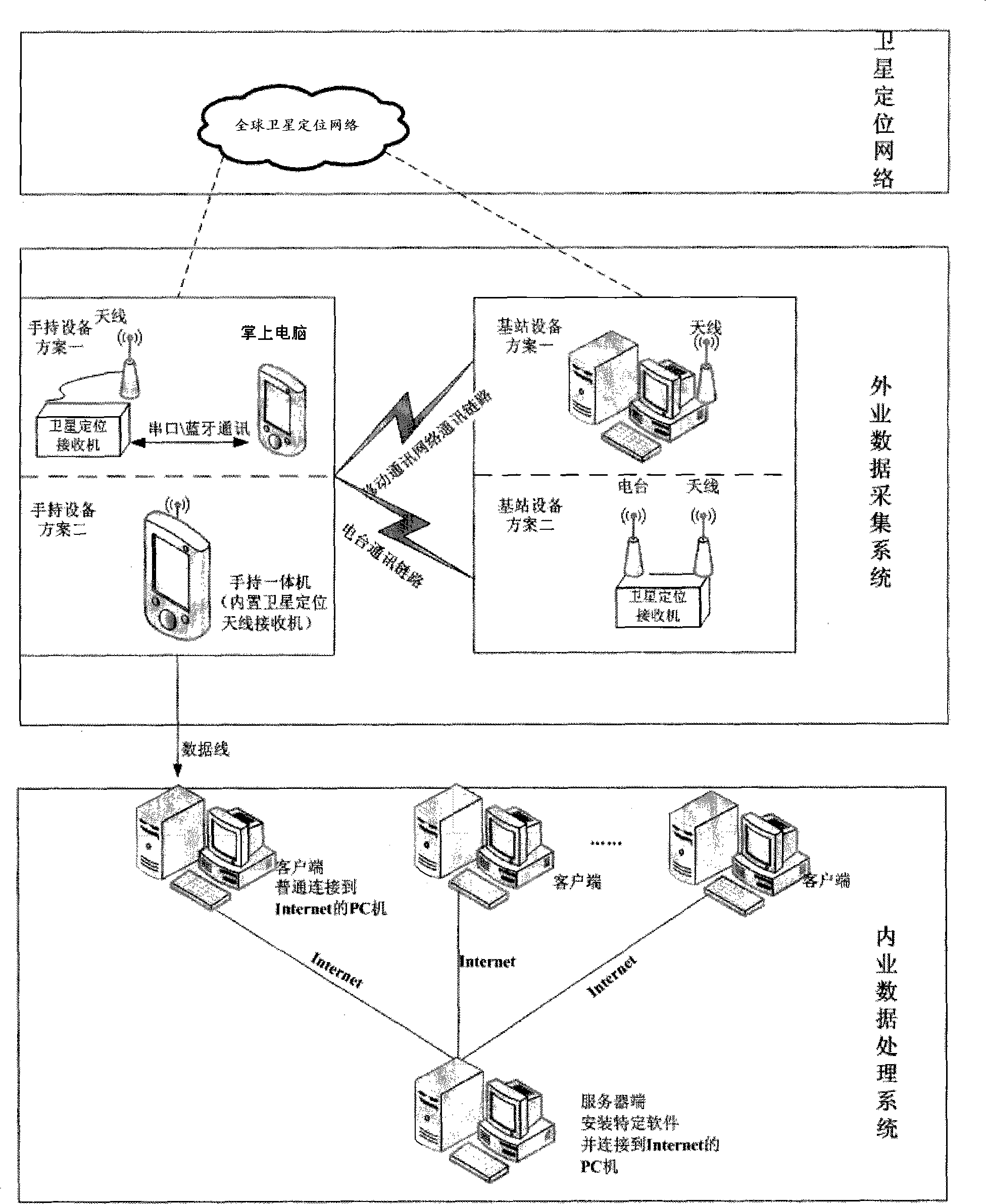
[0048] The specific embodiments of the present invention will be further described below in conjunction with the accompanying drawings.

[0049] Such as figure 1 , the composition of the system of the present invention comprises:

[0050] (1) Global satellite positioning network: GNSS network;

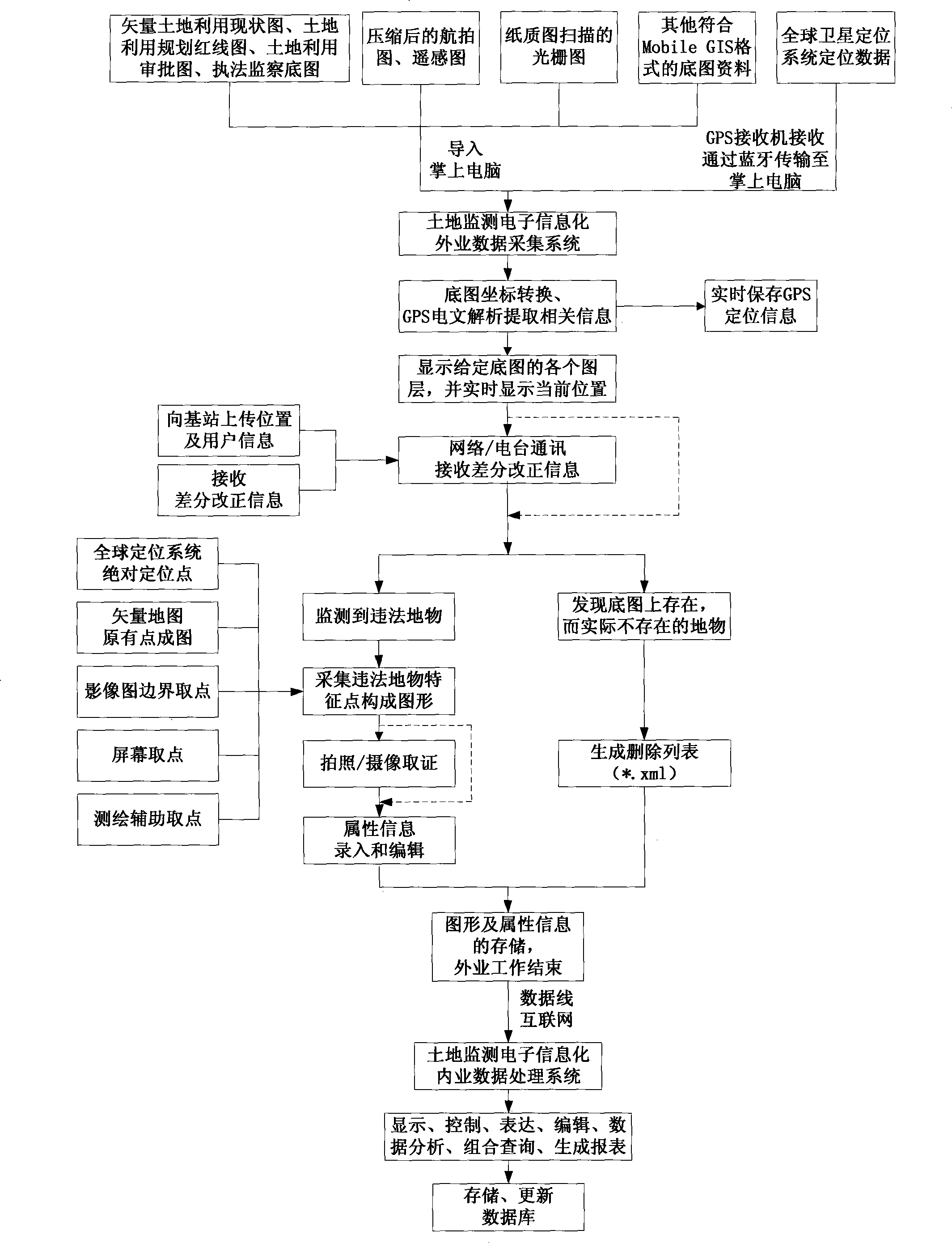
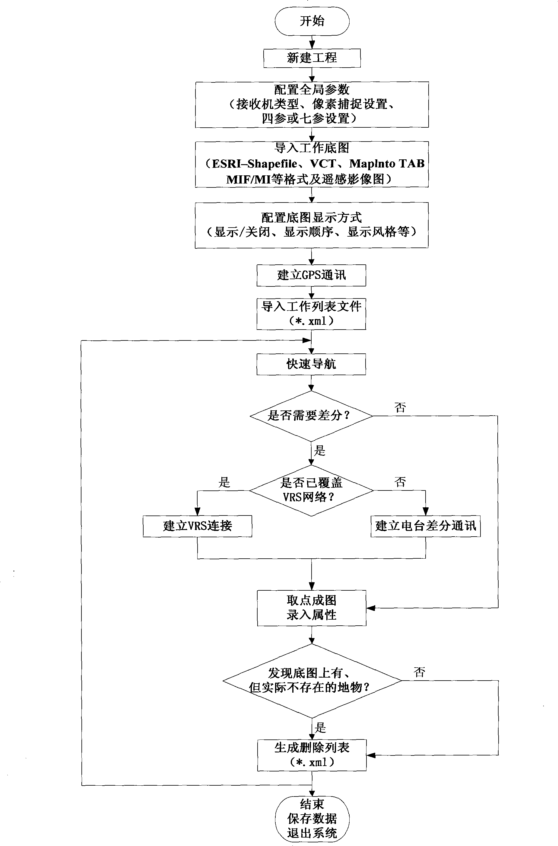
[0051] (2) Field data acquisition system: any one of the following three situations

[0052] ①In the occasions that require high-precision RTD and RTK positioning and have VRS network coverage: a set of GPS receiver and antenna is provided, and the GPS receiver type includes single-frequency receiver with pseudo-range and carrier phase output, L1 and L2 bands Dual-frequency receivers and other forms of satellite positioning receivers that receive satellite signals, perform mobile communications, and store data; equipped with handheld devices with operating systems of Windows Mobile 5.0 and above, cameras, and field data collection software for land monitoring One computer, used as t...


PUM


Abstract

The present invention provides an electronic information system and a method thereof, and constructs two sets of subsystems of field data collecting and indoor data processing. The field data collecting system is based on a Mobile GIS platform and is combined with GPS positioning, GPRS network, bluetooth communication, etc. The field data collecting system realizes high-precision positioning of earth monitoring, uses different methods for executing difference positioning, digital information collecting, eraser list constructing, photograph taking / camera shooting evidence obtaining and terrain hyperlinking for realizing electronic information of field land surveying at the state with / without VRS network. The indoor data processing system is based on SuperMap GIS developing platform and Browser / Server structure, and is combined with XML data interchange, spatial geographical coordinate projection switching, overlapping analyzing, etc. The indoor data processing system realizes multiple functions of indoor multi-source map data expression and operation, combined inquiry, report generation, land monitoring database updating, property formwork customizing, etc., and realizes electronic information of indoor land monitoring operation.

Description

technical field [0001] The present invention relates to the technical field of electronic informatization, in particular to an electronic informatization system and method for land monitoring, and more specifically to the rapid and high-precision acquisition of multi-source spatial data in land monitoring by using field portable equipment. On-site mapping, copying, adding and editing of attribute information, forensics and linking of photos and videos, office analysis of data, combined query and processing, report generation, database update, customization of attribute templates, etc. Background technique [0002] At present, the method of field investigation in the land monitoring industry is: to find suspected illegal and illegal land use through reporting information, remote sensing image data analysis, etc., and the monitoring personnel will take the relevant paper-based land use status map, image map, and land approval documents. On-site measurement and data recording a...

Claims


Application Information

Patent Timeline
10 Jun 2009
Publication
CN101452072A
IPC
G01S5/14; G01C11/04; G06F17/30; G06F19/00; G01S19/46
Inventors
王庆; 于冠男