Topographic survey method

A topographic measurement and ground surface technology, applied in the direction of measuring devices, radio wave measurement systems, radio wave reflection/reradiation, etc., can solve the problem of low calculation efficiency and achieve the effect of great application value

Active Publication Date: 2009-07-15
INST OF ELECTRONICS CHINESE ACAD OF SCI
View PDF3 Cites 19 Cited by
  • Summary
  • Abstract
  • Description
  • Claims
  • Application Information

AI Technical Summary

Problems solved by technology

This algorithm needs to introduce strong a...

Method used


Image

  • Topographic survey method
  • Topographic survey method
  • Topographic survey method

Examples


Embodiment Construction

[0051] Various details involved in the technical solution of the present invention will be described in detail below in conjunction with the accompanying drawings. It should be pointed out that the described embodiments are only intended to facilitate the understanding of the present invention, rather than limiting it in any way.

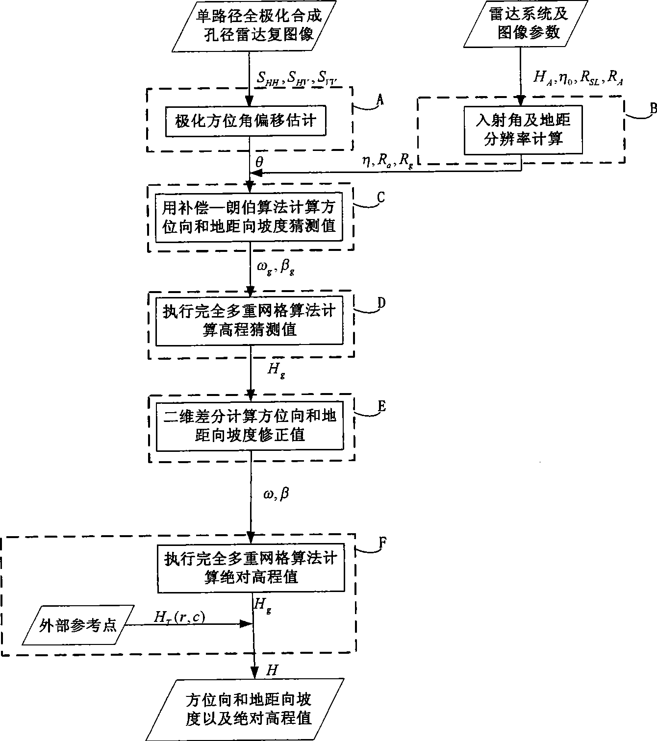
[0052] The flow chart of the topographic measurement method using single-path full-polarization synthetic aperture radar complex image data proposed by the present invention is shown in FIG. 3 . Before the specific elaboration of the steps of the topographic survey, the important symbols used in the invention will be uniformly explained:

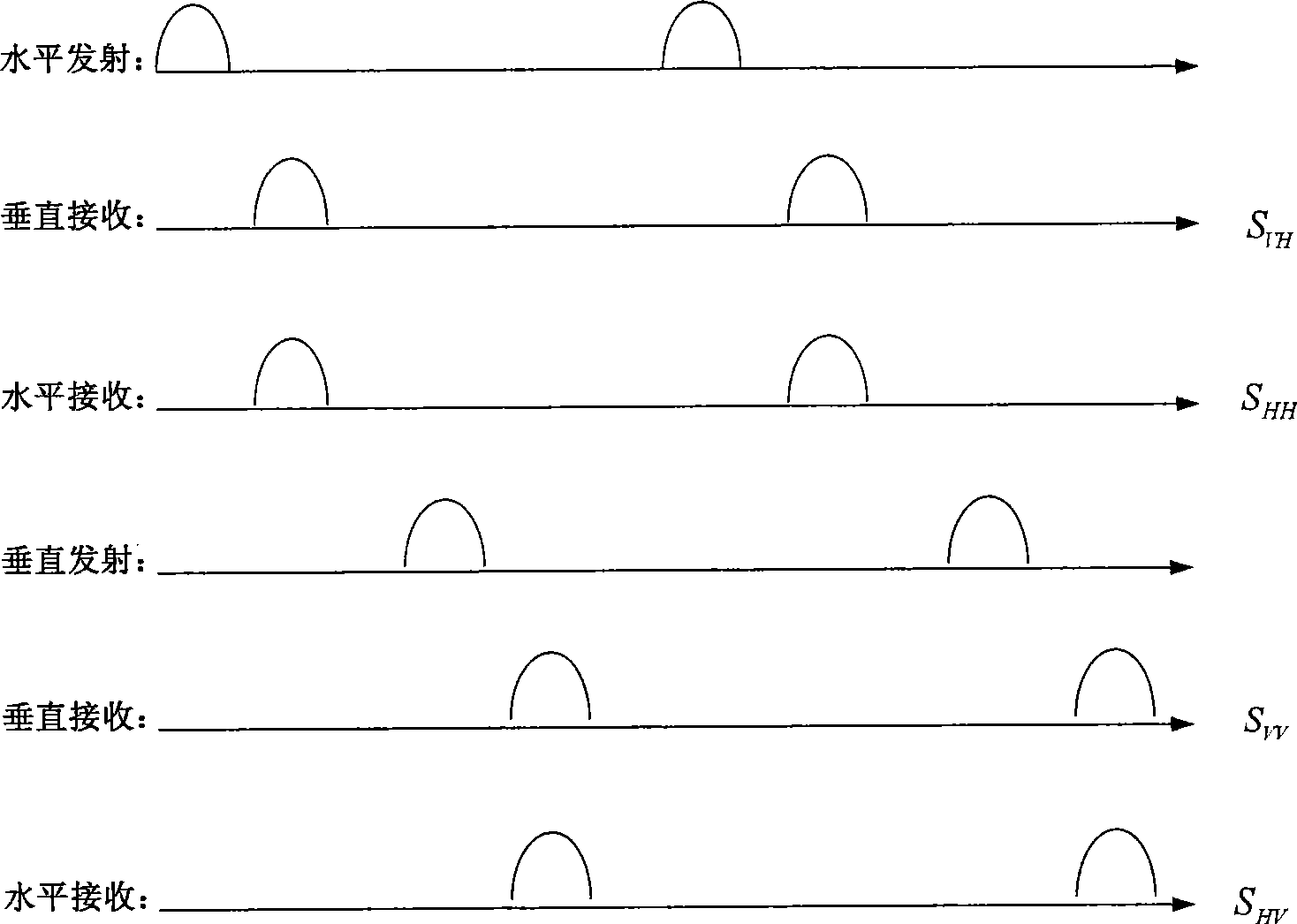
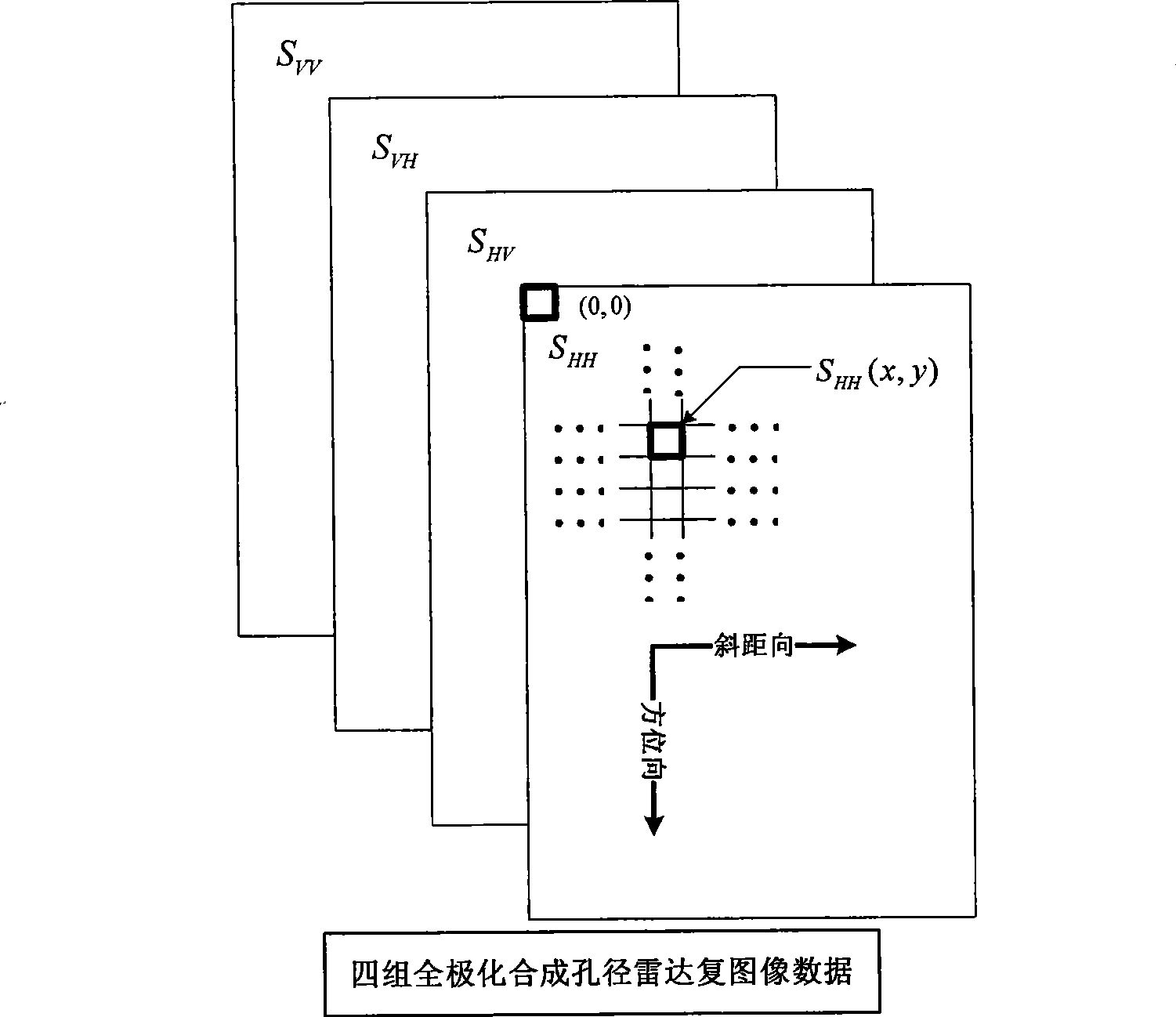
[0053] The fully polarized complex image data consists of 4 complex matrices, each of the same size: M 1 OK, M 2 List. The four matrices are named S HH , S HV , S VH and S VV . S HH (x, y) represents S HH The element in row x and column y in the matrix (counting from 0). In the present invention, the fu...


PUM


Abstract

The invention relates to a topographic surveying method, the method comprises: full polarizing synthetic aperture radar compound image by a single path and calculating to obtain a polarization position angle offset value of each earth's surface unit in the irradiation area adopting circular polarization algorithm; calculating an incidence angle and the resolution of each earth's surface unit by system parameters; calculating the grade guess value of each earth's surface unit by compensation Lambert algorithm; calculating the absolute elevation value of each earth's surface unit by the complete multiple gridding algorithm. A moderate accuracy grade and digital height model can be rapidly obtained by the single path full polarization synthetic aperture radar slant distance compound image data. The method of the invention is characterized in that, the limitation for acquiring radar data is less, the dependence on the exterior data is less, the automatization degree is high and the computational efficiency of the integral process flow is high, thereby the terrain is visible and the application field has larger application value.

Description

technical field [0001] The invention relates to the technical field of information acquisition and processing, in particular to a topographic measurement method using single-path full-polarization synthetic aperture radar complex image data. Background technique [0002] It is a new technology to use the full polarization information of synthetic aperture radar for topographic survey, such as figure 1 shown. Fully polarized radar can form four channels of fully polarized complex image data by transmitting and receiving electromagnetic wave signals in orthogonal directions: S HH , S HV , S VH and S VV ,Such as figure 2 shown. In the backscattering coordinate system, when the target satisfies the assumption of reciprocity, S HV = S VH , so generally only three channels of data are used. S HV Represents the use of the vertical polarization mode of the antenna (V, the direction of the electric field is perpendicular to the incident direction of the electromagnetic wav...

Claims


Application Information

Patent Timeline
IPC IPC(8): G01S13/90G01S7/02
Inventor 李洋洪文曹芳王彦平吴一戎
Owner INST OF ELECTRONICS CHINESE ACAD OF SCI
Why Eureka
Try Eureka