
Method for measuring navigation satellite attitude

A measurement method and technology of navigation satellites, applied in the field of attitude measurement of navigation satellites, can solve the problems of poor operability and high computational complexity

Inactive Publication Date: 2009-12-30
THE 28TH RES INST OF CHINA ELECTRONICS TECH GROUP CORP
View PDF0 Cites 20 Cited by
  • Summary
  • Abstract
  • Description
  • Claims
  • Application Information

AI Technical Summary

Problems solved by technology

[0004] Traditional attitude measurement algorithms using navigation satellites such as the LAMBDA algorithm (Least-squares Ambiguity Decorrelation Adjustment) use a direct solution method when initially solving the ambiguity of the entire circumference, so there are problems such as high computational complexity and poor operability.

Method used


Image

  • Method for measuring navigation satellite attitude
  • Method for measuring navigation satellite attitude
  • Method for measuring navigation satellite attitude

Examples


Embodiment Construction

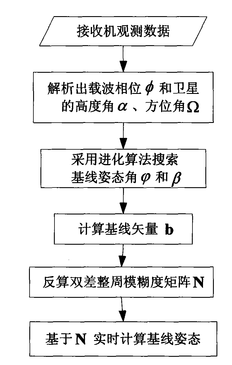
[0036] Such as figure 1 As shown, the present invention discloses a navigation satellite attitude measurement method, comprising the following steps:

[0037] Step 1, the receiver observes the carrier phase of the satellite signal, the geodetic latitude, longitude and navigation message of the observation point;

[0038] Step 2, analyze the carrier phase φ, and analyze the altitude angle α and azimuth angle Ω of the satellite according to the geodetic latitude and longitude of the observation point and the navigation message;

[0039] Step 3, use the ant colony algorithm to search for the baseline attitude angle and β, specifically according to the formula:

[0040] cos [ 2 π ( N ij + δ ij ) ]

[0041]

[0042] Calculate baseline attitude angle and β; where b is the baseline le...


PUM


Abstract

The invention discloses a method for measuring navigation satellite attitude, which comprises the following steps: observing a carrier phase of a satellite signal, geodetic latitude and longitude of an observation point and a navigation message by a receiver; analyzing a carrier phase phi and an elevation angle alpha and an azimuth angle omega of a satellite according to the geodetic latitude and longitude of the observation point and the navigation message; searching a baseline attitude angle phi and a baseline attitude angle beta by using an ant colony algorithm; calculating a baseline vector b; and back-calculating a double-difference integer ambiguity matrix N. The method for measuring the navigation satellite attitude has the following advantages: 1, small amount of calculation: the adoption of the ant colony algorithm for solving an initial attitude angle directly overcomes calculation barriers in resolving an integer ambiguity initially by a conventional method and has fast searching; 2, flexible algorithm: specific parameters of the ant colony algorithm can be selected according to different applications to obtain the maximum performance; and 3, good realizability: the ant colony algorithm is a commonly used algorithm for solving the problem of nonlinear combined optimization and has a plurality of references and good realizability.

Description

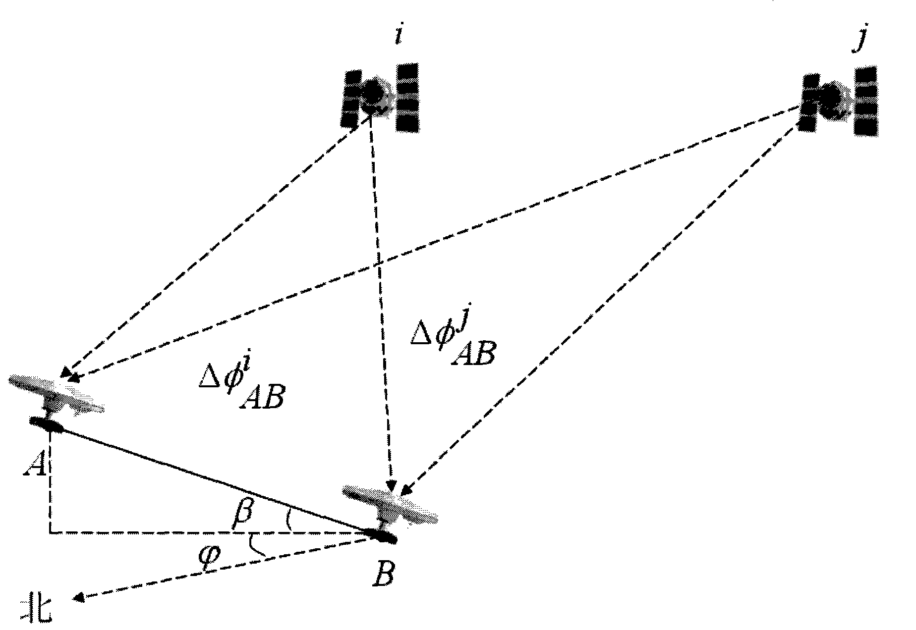
technical field [0001] The invention relates to a navigation satellite attitude measurement method, in particular to a navigation satellite attitude measurement method applicable to various carriers (such as spacecraft, aircraft, ships, etc.) that require attitude measurement. Background technique [0002] Carrier attitude measurement refers to the use of navigation satellite technology to measure the attitude (course angle, pitch angle, and roll angle) of a carrier (spacecraft, aircraft, ship, etc.), which is a key technology in aviation, aerospace, navigation, and land navigation. It has become an important research branch of navigation information processing. [0003] The basic idea of ​​carrier attitude measurement is to properly configure two or more non-collinear satellite antennas on the carrier platform, and use the carrier phase difference measurement technology, that is, use the carrier phase difference received by multiple antennas, the geodetic latitude and longi...

Claims


Application Information

Patent Timeline
IPC IPC(8): G01S3/14
Inventor 常传文
Owner THE 28TH RES INST OF CHINA ELECTRONICS TECH GROUP CORP
Learn More