Method for confirming building floor area ratio based on digital image technology

A digital image and determination method technology, which is applied to the information investigation of urban building volume ratio, and the field of building volume ratio determination based on digital image technology, can solve the problem of the difficulty in accurately determining the building area and the inability to accurately measure the volume ratio of complex buildings and other problems, to achieve the effect of small field workload and high calculation accuracy

Inactive Publication Date: 2009-12-30
SOUTHEAST UNIV
View PDF0 Cites 20 Cited by
  • Summary
  • Abstract
  • Description
  • Claims
  • Application Information

AI Technical Summary

Problems solved by technology

Through the analysis, it is found that the average error of the calculation of the floor area ratio by various remote sensing image interpretation methods is generally around 10%, especially for buildings with complex structures, it is difficult to accurately determine the number of floors of the building and the building area of ​​​​different floors, and it is impossible to accurately measure Floor area ratio of complex buildings (complex buildings mean that the same building has floors with different plane shapes)

Method used


Image

  • Method for confirming building floor area ratio based on digital image technology
  • Method for confirming building floor area ratio based on digital image technology
  • Method for confirming building floor area ratio based on digital image technology

Examples


Embodiment Construction

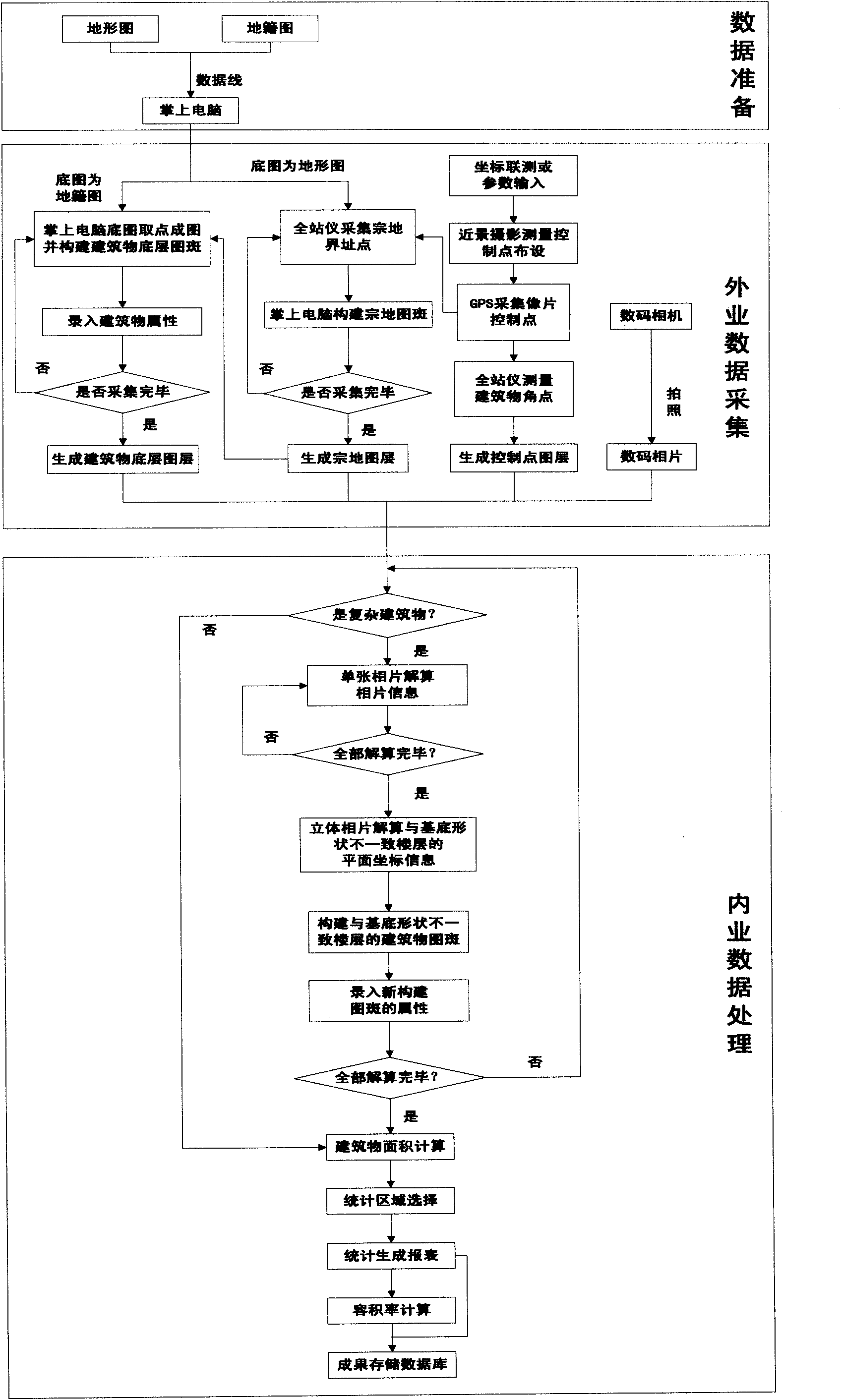
[0033] The specific embodiments of the present invention will be further described below in conjunction with the accompanying drawings.

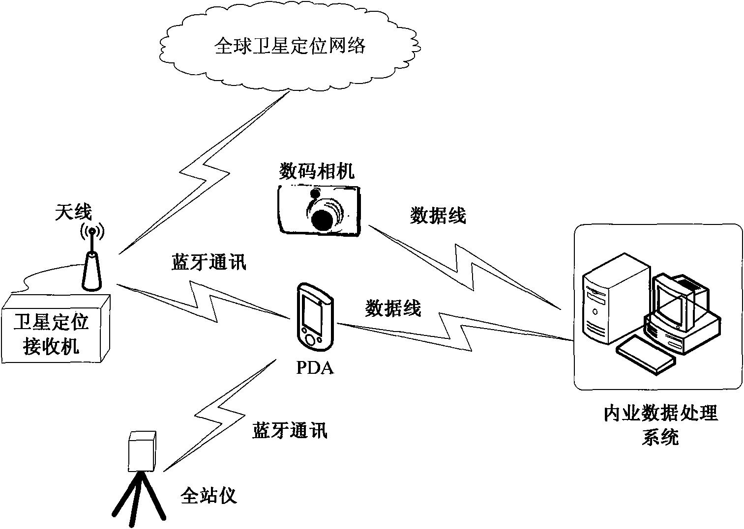
[0034] Such as figure 1 , the investigation method of building floor area ratio based on digital image technology has

[0035] (1) GNSS network for global satellite positioning;

[0036] (2) Field data collection system: a handheld computer with Windows Mobile 5.0 and above operating system and field data collection software installed, a digital camera, a set of GPS RTK equipment, a set of total station equipment, Bluetooth one module;

[0037] (3) Office data processing system

[0038] Internal data processing software and hardware: SQL SERVER, .Net Framework 2.0, Supermap Objects2008, and a computer with internal data processing system installed;

[0039] The above-mentioned office data processing system obtains map data by accessing the map database, and transmits it to the palmtop computer of the field data acquisition system; uses a...


PUM


Abstract

The invention relates to a method for confirming building floor area ratio based on a digital image technology, which takes a personal digital assistant (PDA) and a digital camera as main means and takes GPS and a total station as auxiliary means to realize full digitalization collection and record of field work information. In a field work measurement, the PDA receives the positioning result of the GPS or the total station in real time through bluetooth communication and generates a field work investigation layer by combining with an existing base map in the PDA; the digital camera is utilized to shoot a building so as to obtain abundant building information; and an indoor data processing system can calculate the three-dimensional coordinate of a building corner point of a single image or a three-dimensional image, calculate a total building area, count the total area of a region and calculate the floor area ratio.

Description

technical field [0001] The invention relates to information investigation of urban building volume ratio, in particular to a method for determining building volume ratio based on digital image technology, and belongs to the technical field of land management electronic information. Background technique [0002] With the rapid advancement of urbanization in my country, the urban building volume ratio is an important indicator to measure the degree of urban land use intensification and the level of urban modernization. Management provides important basic spatial information. The building volume ratio refers to the ratio of the total building area in a certain plot to the building area (that is, the area of ​​the parcel). Usually, large-scale topographic maps are used to directly measure and calculate, but the cycle is long and the cost is high. In urban construction, it is necessary to grasp the current urban building volume ratio and estimate it mainly through remote sensing ...

Claims


Application Information

Patent Timeline
Patent Type & Authority Applications(China)
IPC IPC(8): G01S5/02G01B21/04G01C11/00G01B21/28
Inventor 王庆王慧青沙月进张寅方鹏程于冠男
Owner SOUTHEAST UNIV
Why Eureka
Try Eureka