Satellite-image automatic, geometric and precise correction method

A satellite image and fine correction technology, applied in image enhancement, image analysis, image data processing and other directions, can solve problems such as limited application scope, and achieve the effect of reducing operating costs

Inactive Publication Date: 2010-03-17
NAT SATELLITE METEOROLOGICAL CENT
View PDF2 Cites 34 Cited by
  • Summary
  • Abstract
  • Description
  • Claims
  • Application Information

AI Technical Summary

Problems solved by technology

However, this invention is mainly applicable to satellite remote sensing images of mountains, and its application range is relatively limited
[0006] According to the research results published by Taejung Kim, Tae-Yoon Lee and Hae-Jin Choi in the paper "Landmark Extraction, Matching and Processing for Automated Image Navigation of Geostationary Weather Sate

Method used


Image

  • Satellite-image automatic, geometric and precise correction method
  • Satellite-image automatic, geometric and precise correction method
  • Satellite-image automatic, geometric and precise correction method

Examples


Embodiment Construction

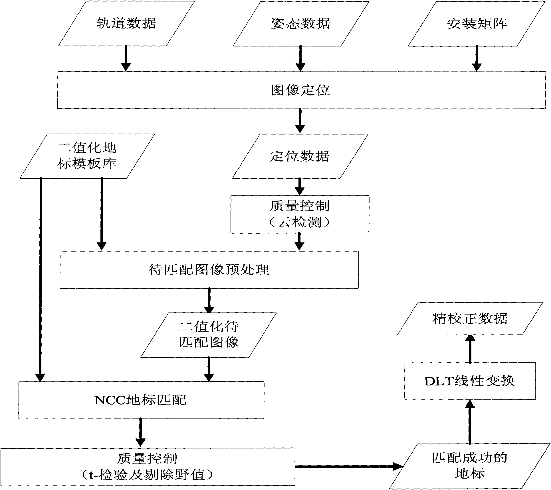
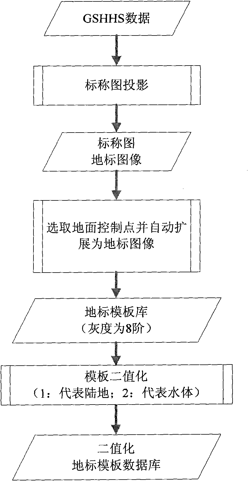
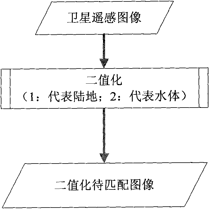
[0027] like figure 1 As shown, the basic process of geometric fine correction based on automatic landmark matching for satellite images is as follows: firstly, using the actual measured satellite orbit data, attitude data and the installation relationship matrix between the satellite body and the observation instrument measured before the satellite launch, Perform image positioning and nominal projection to obtain a nominal map of the satellite image. Then, the nominal map data is processed to obtain the satellite image to be matched, and the satellite image to be matched is binarized according to the Bayes rule in statistics. Afterwards, a matching operation is performed on the binarized landmark template database and the binarized satellite image to be matched to obtain the landmark offset. In this process, attention should be paid to avoid cloud pollution, and at the same time, quality control measures such as hypothesis testing methods in mathematical statistics should be...


PUM


Abstract

The invention discloses a satellite-image automatic, geometric and precise correction method. The method comprises the following steps: (1) a nominal picture of a satellite image is obtained; (2) thenominal picture is processed to obtain the satellite image, and the binarization processing is carried out on the satellite image; (3) the match operation is carried out on a landmark template database after the binarization processing and the satellite image to be matched after the binarization processing, so as to obtain the landmark offset; (4) the result in the step (3) is processed by adopting the quality control measure, so as to obtain a landmark pair that is successfully matched; and (5) the geometric and precise correction is carried out on the nominal picture by adopting the landmarkpair that is successfully matched, so as to obtain the revised locating result. With the adoption of the method, the geometric correction result with higher precision can also be obtained without thelarge amount of careful probing work for the terrain, thereby lowering the running cost of a satellite-image automatic landmark matching system greatly.

Description

technical field [0001] The present invention relates to an automatic geometric fine correction method for satellite images, in particular to an image collected by remote sensing satellites, which first performs automatic landmark matching to obtain landmark offsets, and then uses successfully matched landmark pairs to obtain geometric fine correction The resulting method belongs to the field of remote sensing technology. Background technique [0002] Remote sensing satellite images have become an important data source for people to obtain ground information. At present, for the images collected by remote sensing satellites in the world, the geometric fine correction method based on landmark matching is used to improve the positioning accuracy, so as to improve the application effect of remote sensing satellite quantitative products. [0003] In the early days of the development of remote sensing technology, researchers usually selected landmarks manually for interactive geo...

Claims


Application Information

Patent Timeline
IPC IPC(8): G01C11/04G06T7/00G06T5/00
Inventor 杨磊许健民张志清郭强陆风张晓虎
Owner NAT SATELLITE METEOROLOGICAL CENT
Why Eureka
Try Eureka