Method for acquiring atmospheric horizontal visibility field under maritime dense fog condition

A horizontal visibility and acquisition method technology, applied in the field of acquisition of the atmospheric horizontal visibility field under the condition of dense fog on the sea, can solve the problems of difficult deployment of offshore observation stations, scarce atmospheric visibility observation data, and difficult satellite remote sensing methods, etc.

Inactive Publication Date: 2010-03-17
OCEAN UNIV OF CHINA
View PDF0 Cites 13 Cited by
  • Summary
  • Abstract
  • Description
  • Claims
  • Application Information

AI Technical Summary

Problems solved by technology

[0006] In order to overcome the shortcomings of the satellite remote sensing method that it is difficult to distinguish low clouds and heavy fog, the difficulty of setting up sea observation stations and the scarcity of atmospheric visibility observation data, the present invention selects an internationally advanced regional atmospheric model system (Regional Atmospheric Modeling System (hereinafter referred to as RAMS) simulation results are the basic data. The RAMS atmospheric model is a three-dimensional mesoscale atmospheric model developed by Professor Cotton, a world-renowned cloud and fog physicist at Colorado State University in the United States. It is used in the numerical simulation research of cloud and fog physics. It has the world's advanced level and has been widely recognized and applied

Method used


Image

  • Method for acquiring atmospheric horizontal visibility field under maritime dense fog condition

Examples


Embodiment Construction

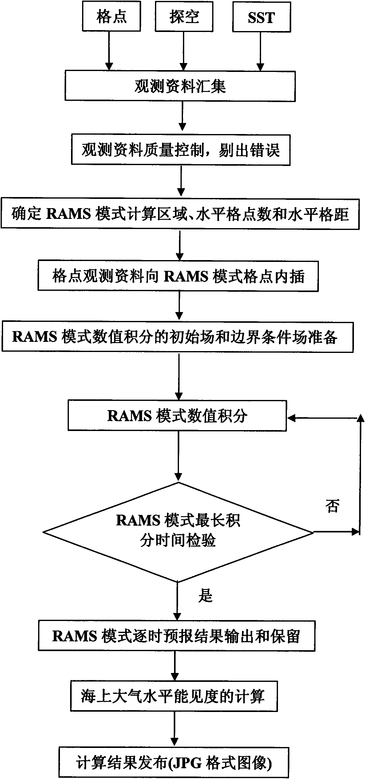
[0018] like figure 1 , as an overall flow chart of the present invention, in which grid point, sounding and SST are all abbreviations of corresponding data.

[0019] Detailed steps of the present invention are as follows:

[0020] (1) Data collection: Under the Linux system, use the shell script language to write and modify the wget command, and download the global objective analysis (Final Analysis, hereinafter referred to as FNL) lattice data (website address http: / / dss.ucar. edu / datasets / ds083.2 / data, the data is global, including SST data, the spatial resolution is 1°×1°, and the time interval is 6 hours), and the sounding data of relevant sounding stations (website Address: http: / / weather.uwoy.edu / upperair / sounding.html);

[0021] (7)(2) Quality control: To control the quality of various data collected, and to eliminate errors, especially through computer programs for the station number, latitude and longitude information, values ​​of each isobaric surface, and potentia...


PUM


Abstract

The invention relates to a method for acquiring an atmospheric horizontal visibility field under a maritime dense fog condition, which comprises the following steps: collecting survey station soundingdata and the like of grid point meteorology and a related sea region, and performing quality control for the survey station sounding data to remove errors; determining a calculation region, a horizontal grid point number and a horizontal grid interval of a regional atmospheric model system RAMS model, interpolating the grid point meteorology data to all horizontal grid points of the RAMS model, preparing an initial condition and boundary condition field, and performing numerical integration for the RAMS model; and outputting and reserving forecast result data files, performing quantitative calculation by using an atmospheric horizontal visibility calculation formula, finally drawing the calculation result into a chromatic atmospheric visibility distribution graph, and outputting images interms of a JPG format. The method can effectively overcome the defects that the maritime atmospheric visibility observation station data is rare, the satellite remote sensing method cannot judge whether the cloud is grounded and the like in the prior art, provides quick and quantitative maritime atmospheric horizontal visibility field for various maritime activities, and has broad application prospect.

Description

technical field [0001] The invention relates to an acquisition method of the atmospheric horizontal visibility field under the sea dense fog condition. Background technique [0002] Sea fog refers to a weather phenomenon in which a large number of water droplets or ice crystals suspended in the atmospheric boundary layer over the ocean (or coastal islands) make the horizontal visibility of the atmosphere less than one kilometer. The American Meteorological Society defines fog as "fog is actually grounded." "cloud", in other words, the essence of fog and cloud is the same, just to see if it is grounded. Because sea fog can seriously reduce the visibility of the atmosphere at sea, and hinder the production of industry, agriculture and fishery in sea and coastal areas, as well as sea, land and air transportation, the research and prediction of sea fog has always been favored by meteorologists and all walks of life. highly valued. [0003] As we all know, there are currently t...

Claims


Application Information

Patent Timeline
Patent Type & Authority Applications(China)
IPC IPC(8): G01N21/17
Inventor 傅刚郭敬天李鹏远高山红
Owner OCEAN UNIV OF CHINA
Why Eureka
Try Eureka