Electromagnetic wave automatic monitoring and analysis system based on GIS

An automatic monitoring and analysis system technology, applied in the field of environmental information processing, can solve the problems of inconvenient comparison and query of historical data, poor drawing accuracy, and long data collection time, so as to facilitate comparison and query work, and shorten data collection. effect of time

Inactive Publication Date: 2010-05-12
SHANDONG UNIV
View PDF0 Cites 10 Cited by
  • Summary
  • Abstract
  • Description
  • Claims
  • Application Information

AI Technical Summary

Problems solved by technology

However, the existing GIS electromagnetic wave monitoring system takes a long time to collect data, the accuracy of drawing is poor, and it is not convenient for the comparison and query of historical data.

Method used


Image

  • Electromagnetic wave automatic monitoring and analysis system based on GIS
  • Electromagnetic wave automatic monitoring and analysis system based on GIS
  • Electromagnetic wave automatic monitoring and analysis system based on GIS

Examples


Embodiment Construction

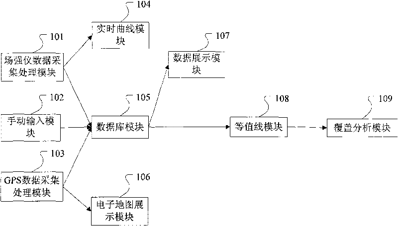
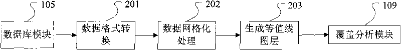
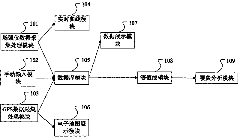
[0026] The GIS-based electromagnetic wave automatic monitoring and analysis system of the present invention is as figure 1 As shown, the module structure of the electromagnetic wave automatic monitoring and analysis system is shown, mainly including: field strength meter data collection and processing module 101, manual input module 102, GPS data collection and processing module 103, real-time curve module 104, database module 105, electronic map Display module 106, data display module 107, contour module 108 and coverage analysis module 109. Among them, the field strength meter data collection and processing module 101 is responsible for collecting data in real time from the field strength meter and outputting the field strength measurement value to the real-time curve module 104 and The database module 105; the manual input module 102 is used to manually enter the field strength data into the database module 105 by the surveyor when automatic measurement value verification or...


PUM


Abstract

The invention provides a GIS-based electromagnetic wave automatic monitoring and analysis system, which comprises an electromagnetic wave field intensity indicator data acquisition and processing module, a manual input module, a GPS data acquisition and processing module, a real-time curve module, a database module, an electronic map display module, a data display module, an isoline module and a cover analysis module. The system realizes the real-time receiving and coverage analysis of electromagnetic signals, can complete the real-time acquisition process of the field intensity data and space orientation data, draws the real-time curve of the field intensity along with the change of time, and monitors the display of the driving track of a vehicle and the drawing of an overlay of the field intensity. Field intensity monitoring equipment, geographic information and the database are integrated on the monitoring vehicle so as to complete the automatic real-time acquisition and analysis work of the information, thus greatly shortening the data acquisition time and drawing accuracy, and being beneficial to the comparison and inquiry on historical data.

Description

technical field [0001] The invention relates to a GIS-based electromagnetic wave automatic monitoring and analysis system that integrates the measurement of space electromagnetic wave intensity with a space positioning system and a geographic information system, which can realize the collection and analysis of electromagnetic environment data based on GIS, and belongs to the field of environmental information processing . Background technique [0002] In recent years, my country's radio industry has developed rapidly, and radio services have penetrated into many fields such as telecommunications, radio and television, transportation, and telemetry. The electromagnetic wave frequencies used also cover medium wave, short wave, ultrashort wave and microwave bands. In order to ensure normal communication services, it is necessary to implement radio management and conduct comprehensive and systematic monitoring of the field strength distribution of electromagnetic waves on a reg...

Claims


Application Information

Patent Timeline
IPC IPC(8): G01R29/08
Inventor 陈涤孙东徐辉
Owner SHANDONG UNIV
Why Eureka
Try Eureka