Non-downsampling contourlet transformation-based method for enhancing remote sensing image road

A non-subsampling contour and contourlet transformation technology, applied in the field of image processing, can solve the problems of large road distortion, loss of road detail information, inaccurate road positioning, etc., achieve accurate road detection and positioning, simple and fast implementation process, and suppress Effects of Noise and Background

Inactive Publication Date: 2010-06-16
XIDIAN UNIV
View PDF0 Cites 11 Cited by
  • Summary
  • Abstract
  • Description
  • Claims
  • Application Information

AI Technical Summary

Problems solved by technology

[0006] However, the current common enhancement methods for remote sensing images only use information in the air domain or frequency domain. The enhanced road distortion will be relatively large, which will affect the subsequent road detection work, resulting in inaccurate road positioning and inaccurate road target recognition.
For example, only using the method of morphological enhancement will widen the width of the original road, causing the location of the road centerline to shift; while only using the frequency domain, such as wavelet domain and contourlet domain, will lose some of the road. Detailed information, resulting in more road breaks and incomplete roads

Method used


Image

  • Non-downsampling contourlet transformation-based method for enhancing remote sensing image road
  • Non-downsampling contourlet transformation-based method for enhancing remote sensing image road
  • Non-downsampling contourlet transformation-based method for enhancing remote sensing image road

Examples


Embodiment Construction

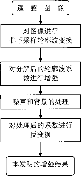
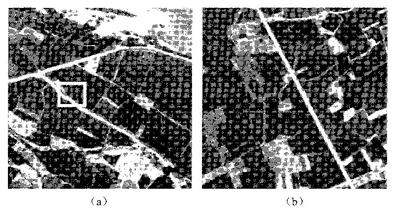
[0032] refer to figure 1 , the implementation of the present invention is as follows:

[0033] Step 1: Perform non-subsampled contourlet transformation on the input image X.

[0034] Perform non-subsampled contourlet transformation on the input image X, in which the number of directions transformed in each layer is divided into 4, 4, and 8 from low to high, and set any direction of the dth layer after contourlet transformation The coefficient is x d (m, n).

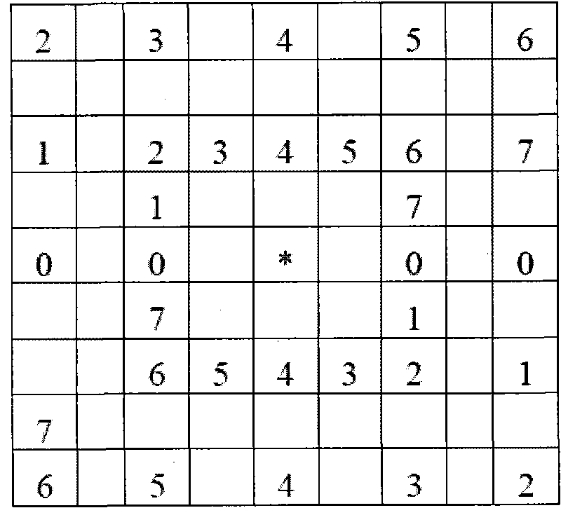
[0035] Step 2, according to the number of directions transformed by each layer, set the corresponding structural element se i (i=1, 2, . . . , the number of r).

[0036] For the 8 directions of the contourlet transform, set 8 [se 0 , se 1 , se 2 , se 3 , se 4 , se 5 , se 6 , se 7 ] structural element, for the 4 directions of contourlet transformation, the corresponding structural element [se 0 , se 2 , se 4 , se 6 ], each structural element se i Both are a matrix of size 9×9, which roughly divide the plan...


PUM


Abstract

The invention discloses a non-downsampling contourlet transformation-based method for enhancing a remote sensing image road, which mainly solves the problems that the road enhanced by the prior art has large distortion and inaccurate road target detection. The method comprises the realization processes of: firstly carrying out 3 layers of non-downsampling contourlet transformation on a remote sensing image, wherein the numbers of the transformed directions of each layer are 4, 4 and 8 arranged from high to low; setting corresponding structural elements according to the numbers of the transformed directions of each layer; then carrying out directional enhancement on transformed coefficients by using the structural elements in the close direction; calculating the direction of each pixel point in the image to acquire a direction matrix of the image; processing noises and backgrounds in the enhanced coefficients through the direction matrix; and carrying out contourlet inverse transformation on the processed enhanced coefficients to acquire an enhancement result of the image. The method can keep the original width of the road when the road is enhanced so as to ensure that the detection of subsequent roads is more accurate, and can be used for analyzing and processing the remote sensing image road.

Description

technical field [0001] The invention belongs to the technical field of image processing and relates to image enhancement, in particular to a remote sensing image road enhancement method, which is suitable for remote sensing image analysis and processing. Background technique [0002] The rapid development of space technology and information technology has provided us with a large amount of remote sensing data, and obtaining target information from remote sensing images has become an important means of spatial information update at this stage. Therefore, how to intelligently interpret massive remote sensing data has become an important issue in the process of informatization construction. As one of the research hotspots, road detection research has been widely concerned, and has very important theoretical and practical significance in the fields of national economic production and military target reconnaissance. Remote sensing image road detection is an important content of ...

Claims


Application Information

Patent Timeline
Patent Type & Authority Applications(China)
IPC IPC(8): G06T5/00
Inventor 钟桦焦李成冯颖涛王爽侯彪杨淑媛张小华王桂婷
Owner XIDIAN UNIV
Why Eureka
Try Eureka