Method for measuring image and inspecting quantity under light detection and ranging (LiDAR) three-dimensional environment

A three-dimensional, quality inspection technology, applied in the field of surveying and mapping, can solve the problems that affect the promotion and use of LiDAR systems, the process is complex, and affect the promotion of photogrammetry technology, so as to achieve the effect of improving practicability and use value and shortening the cycle

Inactive Publication Date: 2010-07-14
WUHAN UNIV
View PDF0 Cites 53 Cited by
  • Summary
  • Abstract
  • Description
  • Claims
  • Application Information

AI Technical Summary

Problems solved by technology

However, the construction of a three-dimensional model requires complex internal orientation, relative orientation, and absolute orientation. It must have professional photogrammetry knowledge. It is completed on professional photogrammetry equipment and professional photogrammetry software. The process is complicated and not conducive to non-photogrammetry majors. The use of personnel affects the promotion of photogrammetry technology
Therefore, using the LiDAR system to produce digital line graph (DLG) products according to the traditional method of photogrammetry to build a three-dimensional model in...

Method used


Image

  • Method for measuring image and inspecting quantity under light detection and ranging (LiDAR) three-dimensional environment
  • Method for measuring image and inspecting quantity under light detection and ranging (LiDAR) three-dimensional environment
  • Method for measuring image and inspecting quantity under light detection and ranging (LiDAR) three-dimensional environment

Examples


Embodiment Construction

[0053] Below in conjunction with accompanying drawing, the present invention will be further described with specific embodiment:

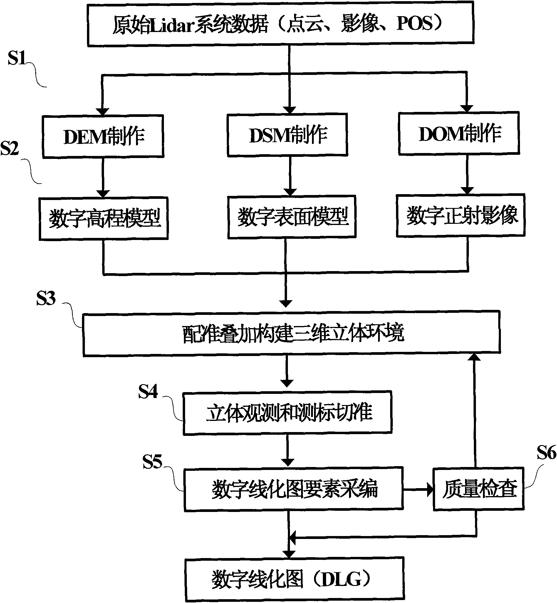
[0054] The method for mapping and quality inspection under the LiDAR three-dimensional environment provided by the present invention specifically adopts the following technical solutions, and its overall flow chart is as follows: figure 1 As shown, the technical solution specifically includes the following steps:

[0055] Step S1: Make digital ground model DSM, digital elevation model DEM, and digital orthophoto DOM respectively according to the multi-sensor data acquired by the LiDAR system;

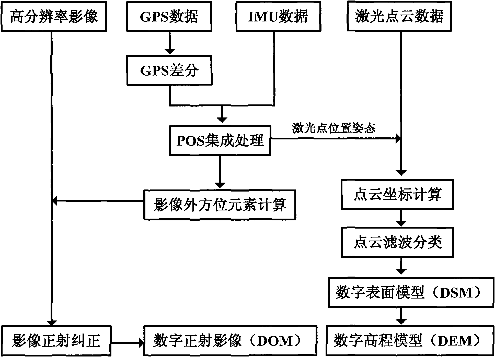
[0056] This step further includes the following sub-steps, and its specific implementation details are as figure 2 Shown:

[0057] ① Obtain the GPS data of the LiDAR system rover station, and jointly perform dynamic carrier phase difference calculation with the base station GPS data to obtain the dynamic positioning data of the carrier;

[0058] ② Input ...


PUM


Abstract

The invention relates to the technical field of mapping, in particular to a method for measuring image and inspecting quantity under the light detection and ranging (LiDAR) three-dimensional environment, comprising the following steps of: respectively manufacturing a digital surface model (DSM), a digital evaluation model (DEM) and a digital ortho image (DOM) according to multiple sensor data obtained by the LiDAR system, respectively layering and partitioning the DSM, the DEM and the DOM in advance, laminating the DSM, the DEM and the DOM to construct a three-dimensional environment, three-dimensionally measuring mark and intersecting, acquiring and cataloging digital line graphic (DLG) elements, and inspecting quality of the DLG. The invention breaks through the limitation that photogrammetric survey needs complex flow chart of data processing and professional photogrammetric survey equipment and software to construct stereopair by two photos, solves the problem that the LiDAR system directly generates the DLG products, shortens the period of DLG production by the LiDAR system, largely improves the practicability and the use value of the LiDAR system, and provides the base for the large-scale application of the LiDAR system in mapping, electricity, city planning, geology and design of road and railway.

Description

technical field [0001] The invention relates to the technical field of surveying and mapping, in particular to a method for surveying and quality inspection in a LiDAR three-dimensional environment. Background technique [0002] In the late 1980s, multi-sensor integrated 3D laser scanning technology (LiDAR, Light Detection AndRanging) produced a major breakthrough in the real-time acquisition of 3D geospatial information, providing a new technology for obtaining high-resolution geospatial information The method enables people to change from traditional manual single-point data acquisition to continuous automatic data acquisition, making it possible to automate and intelligentize data processing. The LiDAR system quickly generates a digital surface model (DSM, Digital Surface Model) and a digital elevation model (DEM, DigitalEvaluation Model) through high-precision POS data, point cloud data and image data, and automatically generates a digital orthophoto (DOM) on this basis....

Claims


Application Information

Patent Timeline
IPC IPC(8): G06T7/60G01C11/04
Inventor 胡庆武李清泉毛庆洲林春峰余飞
Owner WUHAN UNIV
Why Eureka
Try Eureka